
Extreme rainfall event – Rare Red Warning for Heavy Rain issued for Canterbury region of South Island, New Zealand
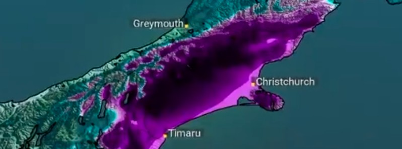
Image credit: NIWA
The New Zealand MetService has issued a rare Red Warning for Heavy Rain for the Canterbury region of South Island for the weekend. Meteorologists warn this could be the most significant rainfall for the region in 10 years. Heavy rain is also expected over other parts of central New Zealand, and severe gales over the South Island's west coast.
- This is only the second Red Warning issued by MetService for the Canterbury region.
- Some areas are expected to receive 2 to 3 months' worth of rain in just 2 to 3 days!
- The rain is expected to cause dangerous river conditions and significant flooding.
- Slips and floodwaters are likely to disrupt travel, making some roads impassable and possibly isolating communities.
- The atmospheric river headed for Canterbury this weekend can be linked back to the Solomon Islands and Fiji, some 4 000 km (2 500 miles) from New Zealand.
- If you live in the affected area, prepare now.
A complex low pressure system over the Tasman Sea is forecast to move slowly southeastwards across northern and central New Zealand over the weekend, May 29 – 30, 2021, before moving away to the east on Monday, May 31.
This system is expected to direct a strong and moist southeast flow across the South Island during this time, delivering an extended period of significant heavy rainfall to Canterbury, and severe gale southeasterlies along the South Island west coast.
In addition, an associated front is forecast to move eastwards across northern and central New Zealand on Saturday, delivering a relatively short burst of heavy rain to some areas.
This is expected to be a significant heavy rainfall event for Canterbury.
The atmospheric river of moisture headed for Canterbury this weekend can be linked back to the Solomon Islands and Fiji — some 4000 km from New Zealand!
moisture-rich air pic.twitter.com/ehTxK6F0Gs
NIWA Weather (@NiwaWeather) May 28, 2021
Our friends at @MetService have issued a red warning for parts of Canterbury this weekend.@niwa_nz in-house modelling indicates 100-250+ mm of rain by 6 pm Monday.
Some areas will receive 2-3 months worth of rain in 2-3 days. https://t.co/DbxR8N3JAZ pic.twitter.com/xjHSpPrOWd
— NIWA Weather (@NiwaWeather) May 28, 2021
A Red Warning for Heavy Rain is in force for the region south of Amberley, and an Orange Warning for Heavy Rain is now in force for the region from Amberley to Kaikoura.
Dangerous river conditions and flooding are expected.
Slips and floodwaters are likely to disrupt travel, making some roads impassable and possibly isolating communities.
The Strong Wind Watch for Fiordland and Westland south of Hokitika has also been upgraded to a Warning for severe southeasterly gales.
People are advised to keep up to date with the latest forecasts in case further areas are added, or any changes are made.
.png)
Credit: NZ Met Service
From 15:00 LT on Saturday, May 29 to 11:00 LT on Monday, May 31, Canterbury High County and foothills can expect 200 to 300 mm (7.9 – 11.8 inches) of rain, with 80 to 120 mm (3.1 – 4.7 inches) of rain farther east about the Plains and coast. Peak hourly rates of 10 to 20 mm (0.4 – 0.8 inches) are expected, especially from later Saturday and during Sunday.
Also note, the freezing level is forecast to be around 1 400 m (4 600 feet) on Saturday, then lifting to around 1 800 m (5 900 feet) on Sunday, before lowering to 1 400 m again on Monday.
Heavy Snow is expected above the freezing level throughout the event, but heavy snow may fall as low as 1 000 m (3 300 feet) in some places at times, especially on Saturday and on Monday.
This rain is expected to cause dangerous river conditions and significant flooding. Slips and floodwaters are likely to disrupt travel, making some roads impassable and possibly isolating communities, MetService meteorologists warned.
From 07:00 to 20:00 LT on Saturday, Canterbury about and north of Amberley, and Marlborough about and south of Kaikoura, can expect 120 to 200 mm (4.7 – 7.9 inches) of rain and peak rates of 10 to 20 mm (0.4 – 0.8 inches) per hour on Saturday evening and during Sunday.
Heavy rain may cause streams and rivers to rise rapidly in this area. Surface flooding and slips are also possible and driving conditions may be hazardous.
From 13:00 LT on Saturday to 09:00 LT on Monday, Westland south of Hokitika and Fiordland can expect southeasterly gales, forecast to be severe at times, with gusts reaching 120 km/h (75 mph).
Winds of this strength could damage trees, powerlines and unsecured structures. Driving may be hazardous, especially for high-sided vehicles and motorcycles.
Weekend Severe Weather
Complex low brings periods of heavy rain, persistent with significant accumulations in Canterbury. Possible severe SE gales for the West Coast.
Read all the details, and stay up to date at https://t.co/qHyE5zhh6X
^AR pic.twitter.com/KxOZRzRqm5
— MetService (@MetService) May 27, 2021
See the rain-bringing low in action.
Numbers are accumulated rain averages from model-see warnings for details.
Orange Rain Warning for NW Nelson 8am-8pm Sat.Red Rain Warning for Canterbury 3pm Sat-11am Mon.
Other areas under Watcheshttps://t.co/qHyE5zhh6X ^TA pic.twitter.com/lkPifRdSY3
— MetService (@MetService) May 28, 2021
I'm a dedicated researcher, journalist, and editor at The Watchers. With over 20 years of experience in the media industry, I specialize in hard science news, focusing on extreme weather, seismic and volcanic activity, space weather, and astronomy, including near-Earth objects and planetary defense strategies. You can reach me at teo /at/ watchers.news.
Commenting rules and guidelines
We value the thoughts and opinions of our readers and welcome healthy discussions on our website. In order to maintain a respectful and positive community, we ask that all commenters follow these rules.