
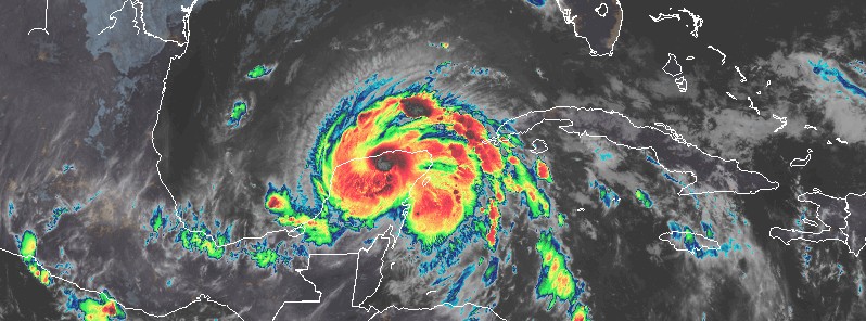
Hurricane “Zeta” makes landfall in Yucatan, heads toward U.S. Gulf Coast
Featured image: Tropical Storm "Zeta" at 09:30 UTC on October 27, 2020. Credit: NOAA/GOES-16, RAMMB/CIRA
Hurricane "Zeta" made landfall along the northeast coast of the Yucatan Peninsula, Mexico near Ciudad Chemuyil around 04:00 UTC on October 27, 2020. The storm had estimated maximum winds of 130 km/h (80 mph), making it a category one hurricane on the Saffir-Simpson Hurricane Wind Scale.
- NHC forecasters expect tropical storm conditions to continue in portions of the northern Yucatan Peninsula through this morning (LT). Heavy rainfall is expected across the Yucatan Peninsula, the Cayman Islands, and western Cuba today, which could lead to flash flooding in urban areas.
- Zeta is forecast to approach the northern Gulf Coast on Wednesday and make landfall late Wednesday or Wednesday night (LT/CDT) at or near hurricane strength.
At the time of landfall, Zeta's center was located about 25 km (15 miles) NNE of Tulum, Mexico, and was moving NW at 20 km/h (13 mph). The storm brought strong winds and heavy rain to the Yucatan Peninsula, along with a storm surge 0.6 – 1.2 m (2 – 4 feet) above normal tides.
By 09:00 UTC today, Zeta was located about 140 km (85 miles) ESE of Progreso, Mexico, and about 905 km (560 miles) S of the mouth of the Mississippi River.
Maximum sustained winds decreased to 110 km/h (70 mph) while minimum central pressure rose to 984 hPa (from 977 hPa at 04:00 UTC).
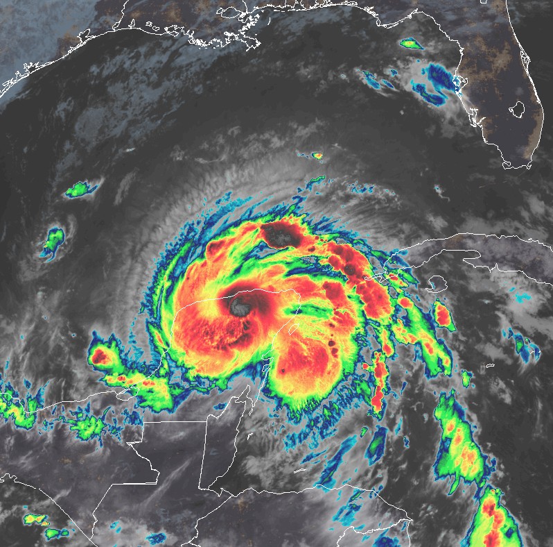
Tropical Storm "Zeta" at 09:30 UTC on October 27, 2020. Credit: NOAA/GOES-16, RAMMB/CIRA
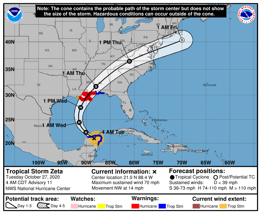
A Storm Surge Warning is in effect for Intracoastal City, Louisiana to Navarre, Florida; Lake Borgne, Lake Pontchartrain, Vermilion Bay, Pensacola Bay, and Mobile Bay.
A Hurricane Warning is in effect for Morgan City, Louisiana to the Mississippi/Alabama border; Lake Pontchartrain, Lake Maurepas, and Metropolitan New Orleans.
A Tropical Storm Warning is in effect for Punta Allen to Progreso, Mexico; Cozumel; Mississippi/Alabama border to Okaloosa/Walton County Line, Florida.
A Tropical Storm Watch is in effect for West of Morgan City to Intracoastal City, Louisiana.
Zeta is currently moving toward the northwest near 22 km/h (14 mph), and this general motion is forecast to continue today, NHC forecasters said.
The system is expected to turn toward the north tonight, followed by a faster northward to north-northeastward motion on Wednesday, October 28.
On the forecast track, the center of Zeta will move over the southern Gulf of Mexico later this morning, and over the central Gulf of Mexico tonight. The system is forecast to re-strengthen when it moves over the southern Gulf of Mexico and become a hurricane again later today.
Zeta is forecast to approach the northern Gulf Coast on Wednesday and make landfall within the hurricane warning area late Wednesday or Wednesday night (LT/CDT) at or near hurricane strength.
NHC forecasters expect tropical storm conditions to continue in portions of the northern Yucatan Peninsula through this morning (LT). Heavy rainfall is expected across the Yucatan Peninsula, the Cayman Islands, and western Cuba today, which could lead to flash flooding in urban areas.
Hurricane conditions and life-threatening storm surge are expected along portions of the northern Gulf Coast by late Wednesday.
Between tonight and Thursday, heavy rainfall is expected from portions of the central U.S. Gulf Coast into the southern Appalachians, and Mid-Atlantic States near and in advance of Zeta. This rainfall will lead to flash, urban, small stream, and minor river flooding.
A few tornadoes are possible Wednesday and Wednesday night over southeastern Mississippi, southern Alabama, and the western Panhandle of Florida.
Louisiana Gov. John Bel Edwards issued a state of emergency on October 26.
"While there is some uncertainty in Zeta’s track, it is likely that Louisiana will see some impacts from this storm, and the people of our state need to take it seriously. It’s easy to let your guard down late in the hurricane season, but that would be a huge mistake," Edwards said.
"The Governor and the Governor’s Office of Homeland Security and Emergency Preparedness (GOHSEP) has already started assisting our local partners with critical items like pumps, generators and food and water for first responders. We stand ready to expand that assistance as needed. Everyone should be monitoring the news for information and should heed any direction they get from their local leaders."
GOHSEP is encouraging everyone to prepare now for any potential threat.
Remember, avoid flooded roadways. Check out the Louisiana Department of Transportation and Development’s website www.511la.org for updated road closure information.
Finalize an emergency communications plan with your family and co-workers.
Keep your phones charged and near you while the threat continues in order to receive potential emergency messaging.
Check your emergency supplies. Remember to include any items needed to sustain each family member for at least 3 days.
Supply kits should include:
- A three to five- day supply of water (one gallon per person per day) and food that won't spoil
- A supply of face coverings, hand sanitizer and disinfectant wipes due to COVID-19 concerns
- One change of clothing and footwear per person, and one blanket or sleeping bag per person
- A first aid kit that includes your family's prescription medications
- Emergency tools including a battery-powered radio, flashlight and plenty of extra batteries
- An extra set of car keys and a credit card, cash or traveler's checks
- Sanitation supplies
- Special items for infant, elderly or disabled family members
- An extra pair of glasses
- Important family documents in a portable, waterproof container
- Mess kits, paper cups, plates and plastic utensils, paper towels
- Paper and pencil
- Books, games, puzzles or other activities for children
- Infant formula and diapers
- Pet food and water
I'm a dedicated researcher, journalist, and editor at The Watchers. With over 20 years of experience in the media industry, I specialize in hard science news, focusing on extreme weather, seismic and volcanic activity, space weather, and astronomy, including near-Earth objects and planetary defense strategies. You can reach me at teo /at/ watchers.news.
Commenting rules and guidelines
We value the thoughts and opinions of our readers and welcome healthy discussions on our website. In order to maintain a respectful and positive community, we ask that all commenters follow these rules.