
Several injured as very destructive, possibly multivortex tornado hits Arles, France

Image credit: La Provence
Several people were injured after a destructive tornado hit the city of Arles, Bouches-du-Rhône, southern France on October 15, 2019. Damage suggests this was a multiple vortex tornado.
Heavy rain with winds up to 113 km/h (70 mph) started affecting the region late October 14, bringing heavy rain to Ardeche, Lozere and the Alpes-Maritimes.
In just 24 hours, Barnas in Piedmont Cevennes received 136 mm (5.35 inches) of rain. This is its two weeks of average rainfall.
The twister touched down in Arles' neighborhood of Pont-de-Crau around 04:50 LT on October 15, damaging cars and homes, downing trees and leaving the area without electricity.

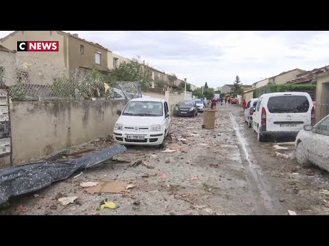
About 150 homes were damaged or destroyed, including caravans and mobile homes in a nearby campsite. Some 60 people had to be temporarily relocated, an official at the Departmental operational fire and rescue center said.
Five people were injured, and one of them hospitalized.


According to Paul Marquis of The Weather of 13, the tornado traveled a distance of up to 6 km (3.7 miles) and was between 150 and 200 m (490 – 650 feet) wide, max up to 350 m (1 150 feet) in some places.
It was on the ground for 7 to 9 minutes and had winds of about 180 – 200 km/h (112 – 125 mph), making it an EF-2 category.
"After field investigation, it appears that it could have been multiple vortex tornado," Marquis said. "That is, there were not 1 but potentially 2 distinct cones at certain times. Indeed, within the main corridor of damage, we have seen differences. Not all this is proven at 100 %, but it's likely."
[#Opérations] Des dégâts importants sur #Arles vus par #drone + de 150 maisons endommagées, les reconnaissances se poursuivent par les #Pompiers13 pic.twitter.com/fizQSVOsvk
— Pompiers 13 (@Pompiers_13) October 15, 2019
#Tornade en #Arles : les dégâts sur places dont certains sur ces photos du SDIS13, laissent penser qu’il s’agit d’une tornade d’intensité EF1 voire même EF2. Certaines toitures entièrement envolées et près de 150 maisons touchées selon un dernier bilan. pic.twitter.com/SzSqgx8Hsn
— Agate Météo (@AgateMeteo) October 15, 2019
#Tornade dévastatrice en #Arles où certaines maisons sont sévèrement endommagées. Au moins 40 habitations ont été touchées, avec parfois même la toiture envolée. Photo de Lucas Iglesias via LCI pic.twitter.com/J8SWjPHQQx
— Agate Météo (@AgateMeteo) October 15, 2019
>> TORNADE sur Pont-de-Crau (Arles) la nuit dernière vers 4H du matin.
Nombreux dégâts reportés.
Le risque était bien présent.
Photos : Chloé et Seb. pic.twitter.com/Dc7XF8I790
— La Météo du 13 (@La_Meteo_du_13) October 15, 2019

Teo Blašković founded The Watchers in 2011 and edited it until 2026, covering seismic and volcanic activity, extreme weather, space weather and near-Earth objects. Articles on this page are his archive.
Published in the last 24 hours
- How did one flash of lightning, lasting about seven seconds, stretch 829 km across five US states, beat the previous record by 61 km, and only be recognized as the longest ever measured nearly eight years later?
- A meteorite blew a crater beside a village near Lake Titicaca in 2007, and dozens of villagers who went to see it got headaches and nausea, though tests found nothing the rock had added to the water Epicenter
- The people who pay closest attention to the weather are the ones storms have already cost the most, a study of 946 students found, with one damaging storm making little difference to how much attention a student paid, but two or more making a clear one Epicenter
- The sea is falling in Juneau, Alaska, because land freed from melted glaciers is rising about 0.6 inches a year Epicenter
