
Dorian makes landfall in North Carolina, heads toward Canada
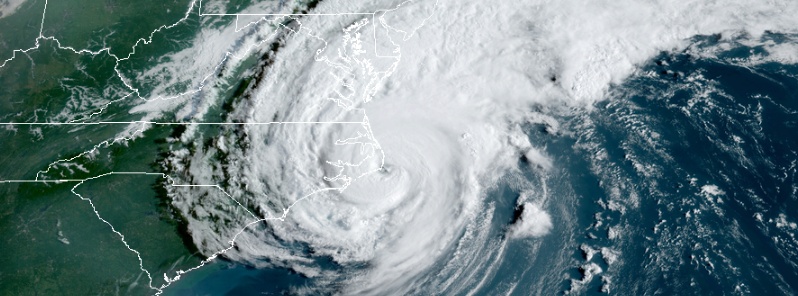
Featured image: Hurricane "Dorian" making landfall over North Carolina on September 6, 2019. Credit: NOAA/GOES-East
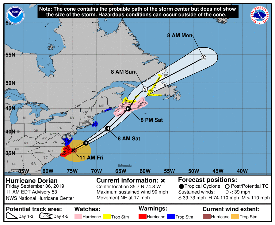
Hurricane "Dorian" made landfall over the Cape Hatteras, North Carolina at 12:35 UTC (08:35 EDT) on September 6, 2019. With 3 over the Bahamas, this is its fourth landfall but not final as it continues moving toward Nova Scotia, Canada where it is expected to make landfall as a Category 1 hurricane late September 7 or early September 8.
At least 4 people lost their lives in the USA and at least 30 in the Bahamas. However, the death toll in the Bahamas is expected to keep rising and some reports mention Dorian could already be one of the deadliest hurricanes on record.
Surface and radar data indicate that the center of Hurricane Dorian made landfall at 12:35 UTC over Cape Hatteras, North Carolina with maximum sustained winds were near 150 km/h (90 mph), making it a Category 1 hurricane on the Saffir-Simpson Hurricane Wind Scale.
Other stations at Hatteras High School and Buxton both recently reported a minimum central pressure of 957 hPa.
At 13:00 UTC, Dorian's center was located about 5 km (3.1 miles) NE of Cape Hatteras, North Carolina. The system was moving NE at 22 km/h (14 mph) with minimum central pressure of 956 hPa.
By 15:00 UTC (11:00 EDT), its center was already 85 km (50 miles) NE of Cape Hatteras and 740 km (460 miles) SW of Nantucket, Massachusetts. Its maximum sustained winds remained at 150 km/h (90 mph) and minimum central pressure at 957 hPa.
It was moving NE at 28 km/h (17 mph) and this general motion is expected through Saturday night, September 7.
The center should move to the southeast of extreme southeastern New England tonight and Saturday morning, and then across Nova Scotia late Saturday or Saturday night.
Slow weakening is expected through Saturday. After that, Dorian is forecast to become a post-tropical cyclone with hurricane-force winds by Saturday night as it approaches Nova Scotia.
Hurricane conditions should end along portions of the North Carolina coast during the next few hours. Tropical storm conditions should continue on the southeastern coast of Virginia for the next several hours, and are expected to spread across other portions of the Mid-Atlantic states later today.
Tropical storm conditions are also expected in the warning area over portions of extreme southeastern Massachusetts tonight or early Saturday, and in the warning area in Maine Saturday afternoon. Hurricane conditions are possible in Nova Scotia and Prince Edward Island Saturday, and tropical storm conditions are possible over other portions of the Canadian Maritime and Atlantic areas Saturday and Saturday night.
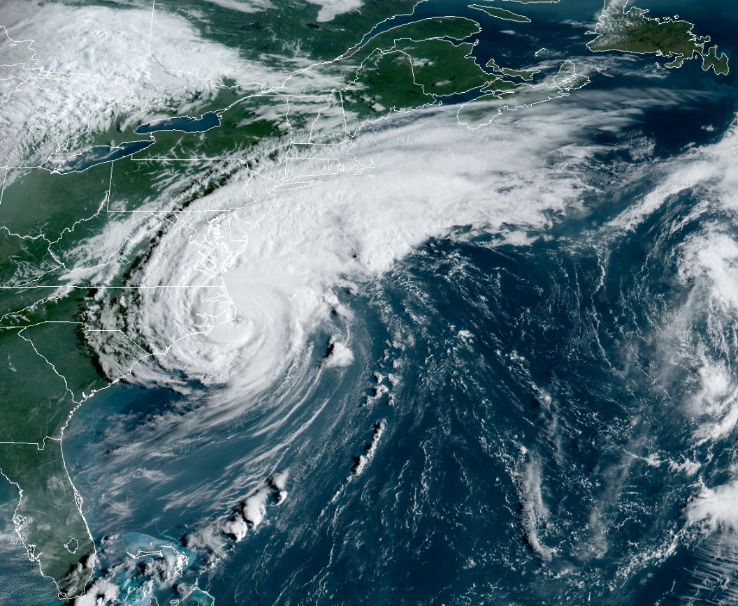
Hurricane "Dorian" at 12:30 UTC on September 6, 2019. Credit: NOAA/GOES-East
The combination of a dangerous storm surge and the tide will cause normally dry areas near the coast to be flooded by rising waters moving inland from the shoreline.
The water could reach the following heights above ground somewhere in the indicated areas if the peak surge occurs at the time of high tide:
Salter Path to Duck NC, including Pamlico and Albemarle Sounds and the Neuse and Pamlico Rivers: 1.2 to 2.1 m (4 to 7 feet)
Duck NC to Poquoson VA, including Hampton Roads: 0.6 – 2.1 m (2 to 4 feet)
Water levels could begin to rise well in advance of the arrival of strong winds. The surge will be accompanied by large and destructive waves. Surge-related flooding depends on how close the center of Dorian comes to the coast, and can vary greatly over short distances.
Storm Surge is likely in the Gulf of St. Lawrence, the Southwest Coast of Newfoundland, and Eastern Nova Scotia.
Dorian is expected to produce the following rainfall totals through Saturday:
Northeastern North Carolina into far southeast Virginia: Additional 25 – 100 mm (1 to 4 inches), isolated storm totals 250 mm (10 inches).
Extreme Southeastern New England: 50 – 100 mm (2 to 4 inches).
Nova Scotia and Prince Edward Island: 75 – 130 mm (3 to 5 inches).
Newfoundland: 20 – 50 mm (1 to 2 inches)
This rainfall may cause life-threatening flash floods
Large swells will affect much of the southeastern United States coast from northern Florida through North Carolina during the next couple of days. These swells are likely to cause life-threatening surf and rip current conditions.
A Storm Surge Warning is in effect for:
- Salter Path, NC to Poquoson, VA
- Pamlico and Albemarle Sounds
- Neuse and Pamlico Rivers
- Hampton Roads
A Hurricane Warning is in effect for:
- Bogue Inlet to the North Carolina/Virginia border
- Pamlico and Albemarle Sounds
A Hurricane Watch is in effect for:
- Nova Scotia
A Tropical Storm Warning is in effect for:
- North Carolina/Virginia border to Fenwick Island, DE
- Chesapeake Bay from Drum Point southward
- Tidal Potomac south of Cobb Island
- Woods Hole to Sagamore Beach, MA
- Nantucket and Martha's Vineyard, MA
- East of Bar Harbor to Eastport, ME
A Tropical Storm Watch is in effect for:
- Prince Edward Island
- Magdalen Islands
- Fundy National Park to Shediac
- Francois to Boat Harbour
Dorian caused widespread power outages, with hundreds of thousands without power. As of 16:00 UTC, 209 275 customers are without power in North Carolina, 119 908 in South Carolina, 45 798 in Virginia and 8 102 in West Virginia.
Widespread flooding was reported and tornadic damage throughout the Carolinas. NWS SPC is reporting 13 preliminary tornadoes in North Carolina.
Record rains were registered in many places, including Myrtle Beach in South Carolina where NWS recorded 263 mm (10.39 inches) in 24 hours ending 00:00 LT, September 5. Its previous daily record was 91.6 mm (3.61 inches) set in 2009. Wilmington in North Carolina registered 217.9 mm (8.58 inches) during the same period. The city receives 200 mm (7.88 inches) during the entire month of September.
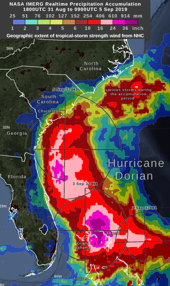
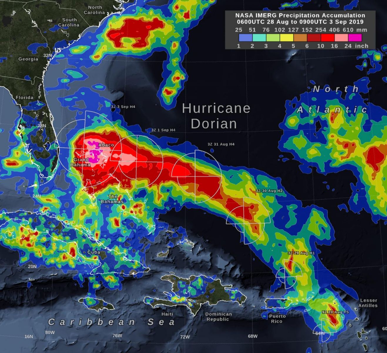
Credit: NASA/IMERG
At least 4 people lost their lives in the United States – 2 in Florida and 1 each in North Carolina and Puerto Rico.
At least 30 people died in the Bahamas but authorities there say the number will continue rising.
I'm a dedicated researcher, journalist, and editor at The Watchers. With over 20 years of experience in the media industry, I specialize in hard science news, focusing on extreme weather, seismic and volcanic activity, space weather, and astronomy, including near-Earth objects and planetary defense strategies. You can reach me at teo /at/ watchers.news.
Commenting rules and guidelines
We value the thoughts and opinions of our readers and welcome healthy discussions on our website. In order to maintain a respectful and positive community, we ask that all commenters follow these rules.