
Hurricane “Dorian” – damaging winds and life-threatening storm surges along the Southeast and Mid-Atlantic coasts of USA
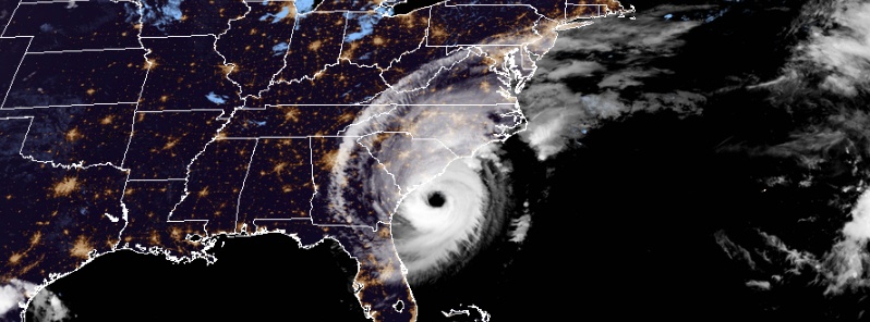
Featured image: Hurricane "Dorian" at 09:00 UTC on September 5, 2019. Credit: NOAA/GOES-East
Hurricane "Dorian" is expected to bring damaging winds and life-threatening storm surges along a large portion of the Southeast and Mid-Atlantic coasts of the United States during the next couple of days, NHC warns. It continues to lash the coast of the Carolinas, with hurricane conditions likely over portions of the area later today. The center of Dorian will continue to move close to the coast of South Carolina through the day, and then move near or over the coast of North Carolina tonight and Friday.
A Storm Surge Warning is in effect for:
- Savannah River to Poquoson, VA
- Pamlico and Albemarle Sounds
- Neuse and Pamlico Rivers
- Hampton Roads
A Hurricane Warning is in effect for:
- Savannah River to the North Carolina/Virginia border
- Pamlico and Albemarle Sounds
A Tropical Storm Warning is in effect for:
- North Carolina/Virginia border to Chincoteague, VA
- Chesapeake Bay from Smith Point southward
A Tropical Storm Watch is in effect for:
- North of Chincoteague, VA to Fenwick Island, DE
- Chesapeake Bay from Smith Point to Drum Point
- Tidal Potomac south of Cobb Island
- Woods Hole to Sagamore Beach, MA
- Nantucket and Martha's Vineyard, MA
"Even if there isn't a landfall, the impacts are still going to be great everywhere from the Georgia coast toward the Carolina coast, but I'm more worried about more significant impacts along the South Carolina coast and the North Carolina coast over the next 48 hours or so," AccuWeather Chief Broadcast Meteorologist Bernie Rayno said.
The death toll in the Bahamas climbed to at least 20 on Wednesday, September 4, 17 from the Abaco islands and three from Grand Bahama, according to the Associated Press. However, there are reports coming out suggesting a much larger number.
"We can expect more deaths to be recorded," Bahama Prime Minister Hubert Minnis said on Tuesday at a press briefing. "Our priority at this time is search, rescue and recovery. We are in the midst of one of the greatest national crises in our country’s history."
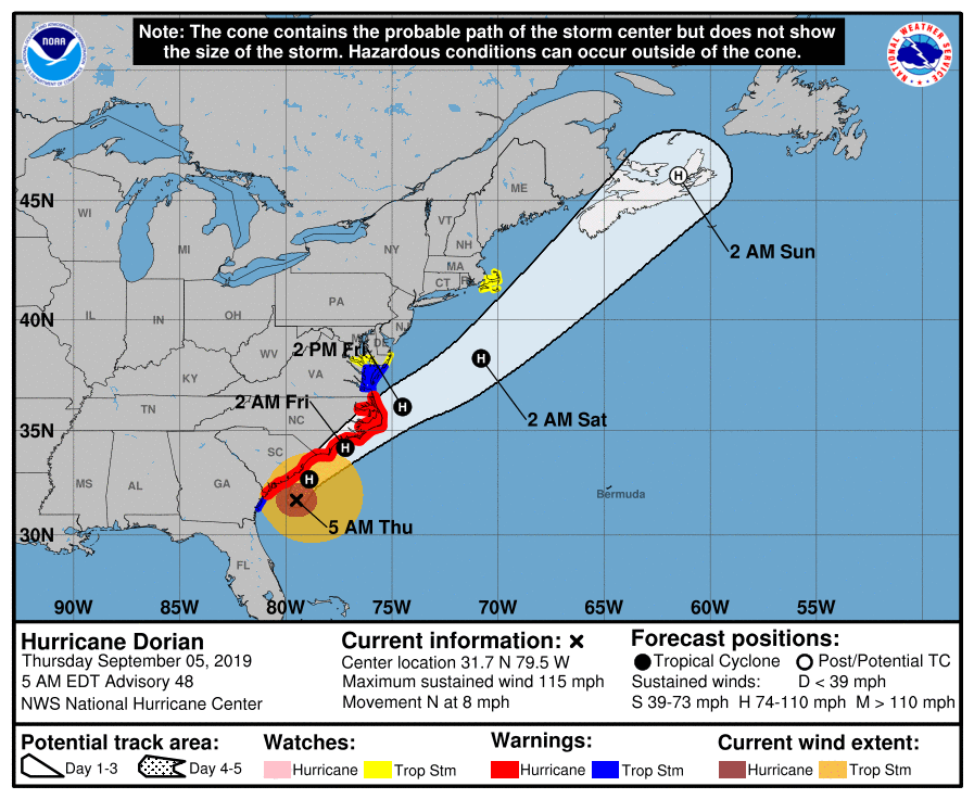
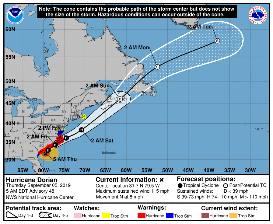
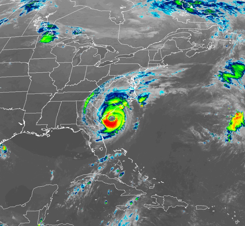
At 09:00 UTC on September 5, the center of Hurricane "Dorian" was located about 130 km (80 miles) SSE of Charleston, South Carolina and about 320 km (200 miles) SSW of Wilmington, North Carolina.
Its maximum sustained winds were 185 km/h (115 mph) and minimum central pressure 957 hPa. The system is moving N at 13 km/h (8 mph).
Dorian is a category 3 hurricane on the Saffir-Simpson Hurricane Wind Scale. Some fluctuations in intensity are expected this morning, followed by slow weakening through Saturday, September 7. However, Dorian is expected to remain a hurricane for the next few days.
A turn to the north- northeast is anticipated today, with a turn toward the northeast by tonight (EDT). A northeastward motion at a faster forward speed is forecast on Friday, September 6.
On the forecast track, the center of Dorian will continue to move close to the coast of South Carolina through the day, and then move near or over the coast of North Carolina tonight and Friday.
The center should move to the southeast of extreme southeastern New England Friday night and Saturday morning, and approach Nova Scotia later on Saturday.
Hurricane-force winds extend outward up to 95 km (60 miles) from the center, and tropical-storm-force winds extend outward up to 315 km (195 miles). The National Weather Service Forecast Office in Charleston, South Carolina, recently reported a wind gust to 109 km/h (68 mph) at the Charleston International Airport.
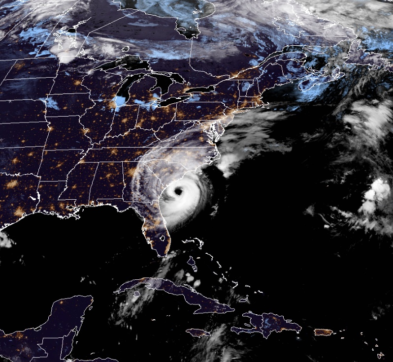
Hurricane "Dorian" at 09:10 UTC on September 5, 2019. Credit: NOAA/GOES-East
Tropical storm conditions are currently affecting portions of the Georgia and South Carolina coasts. Hurricane conditions are expected along portions of the South Carolina coast later this morning.
Tropical storm conditions will begin along the coast of North Carolina within the next couple of hours, with hurricane conditions beginning later today. Tropical storm conditions are expected in the Tropical Storm Warning area in the Mid-Atlantic states by Friday, with tropical storm conditions possible in the Tropical Storm Watch area Friday or Friday night.
Tropical storm conditions are possible over portions of southeastern Massachusetts by late Friday or early Saturday.
The combination of a dangerous storm surge and the tide will cause normally dry areas near the coast to be flooded by rising waters moving inland from the shoreline.
The water could reach the following heights above ground somewhere in the indicated areas if the peak surge occurs at the time of high tide:
Isle of Palms to Myrtle Beach, SC: 1.5 – 2.4 m (5 to 8 feet)
Savannah River to Isle of Palms, SC: 1.2 – 2.1 m (4 to 7 feet)
Myrtle Beach, SC to Cape Lookout, NC: 1.2 – 2.1 m (4 to 7 feet)
Cape Lookout, NC to Duck, NC, including Pamlico and Albemarle Sounds and the Neuse and Pamlico Rivers: 1.2 m – 1.8 m (4 to 6 feet)
Duck, NC to Poquoson, VA, including Hampton Roads: 0.6 – 1.2 m (2 to 4 feet)
Water levels could begin to rise well in advance of the arrival of strong winds. The surge will be accompanied by large and destructive waves. Surge-related flooding depends on how close the center of Dorian comes to the coast, and can vary greatly over short distances.
Dorian is expected to produce the following rainfall totals through Friday:
Coastal Carolinas: 150 – 300 mm (6 to 12 inches), isolated 380 mm (15 inches)
Coastal Georgia: 50 – 100 mm (2 to 4 inches), isolated 300 mm (6 inches)
Far southeast Virginia: 75 – 150 mm (3 to 6 inches)
Extreme southeastern New England: 50 – 100 mm (2 to 4 inches)
This rainfall may cause life-threatening flash floods.
Large swells will affect the northwestern Bahamas, and the entire southeastern United States coast from Florida through North Carolina during the next few days. These swells are likely to cause life-threatening surf and rip current conditions.
A few tornadoes are possible through this afternoon near the coastal South and North Carolina border area. This threat will expand northeastward across the rest of eastern North Carolina during the afternoon and continue into tonight.
Forecast models
I'm a dedicated researcher, journalist, and editor at The Watchers. With over 20 years of experience in the media industry, I specialize in hard science news, focusing on extreme weather, seismic and volcanic activity, space weather, and astronomy, including near-Earth objects and planetary defense strategies. You can reach me at teo /at/ watchers.news.
Commenting rules and guidelines
We value the thoughts and opinions of our readers and welcome healthy discussions on our website. In order to maintain a respectful and positive community, we ask that all commenters follow these rules.