
Strong eruption at Agung volcano, several flights canceled – Bali, Indonesia
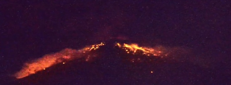
Image credit: Volcano YT
Indonesian Agung volcano erupted again on Friday, May 24, 2019, ejecting ash up to 4.5 km (15 000 feet) above sea level.
The eruption took place at 11:23 UTC (19:23 WITA) and lasted for 4 minutes and 30 seconds.
The Darwin VAAC said volcanic ash was observed on multispectral satellite imagery up to 4.5 km (15 000 feet) a.s.l. Distinguishable hot spot and incandescent lava flow were observed on webcam imagery 3 km (1.8 miles) from the crater.
A thin layer of ash covered nearby villages. Several flights to and from Bali international airport have been canceled.
The eruption of Mount Agung, Bali, occurred on May 24, 2019 at 7:23 p.m. but the ash column height was not observed. This eruption is recorded on a seismogram with a maximum amplitude of 30 mm & duration of ± 4 minutes 30 seconds.there was a roaring noise at the Observation Post. pic.twitter.com/q1P3yzFhbn
— Cho Hamsyonk (@Cho_Hamsyonk) May 24, 2019
bahkan ada yang kejatuhan pecahan tambang, dari lontaran ledakan pic.twitter.com/qEW5dg6slK
— Cho Hamsyonk (@Cho_Hamsyonk) May 24, 2019
the impact of the rain of ash from the volcano Agung, Karangasem, Bali.
Friday, May 24, 2019 pic.twitter.com/JzABa53xrc— Cho Hamsyonk (@Cho_Hamsyonk) May 24, 2019
"Thundering sounds from the eruption were heard adequately strong from the monitoring post," Indonesia's Center of Volcanology and Geological Disaster Mitigation (PVMBG) said.
Residents and tourists are strictly prohibited to enter danger zone 4 km (2.5 miles) around the crater.
Residents living around nearby rivers are advised to remain vigilant on the possible stream of hot lava or volcanic materials.
Geological summary
Symmetrical Agung stratovolcano, Bali's highest and most sacred mountain, towers over the eastern end of the island. The volcano, whose name means " Paramount," rises above the SE caldera rim of neighboring Batur volcano, and the northern and southern flanks of Agung extend to the coast.
The 3142-m-high (10 308 feet) summit contains a steep-walled, 500-m-wide (1 640 feet), 200-m-deep (656 feet) crater. The flank cone Pawon is located low on the SE side.
Only a few eruptions dating back to the early 19th century have been recorded in historical time. The 1963-64 eruption, one of the world's largest of the 20th century, produced voluminous ashfall along with devastating pyroclastic flows and lahars that caused extensive damage and many fatalities.
I'm a dedicated researcher, journalist, and editor at The Watchers. With over 20 years of experience in the media industry, I specialize in hard science news, focusing on extreme weather, seismic and volcanic activity, space weather, and astronomy, including near-Earth objects and planetary defense strategies. You can reach me at teo /at/ watchers.news.
please suggest me some Bali Tour Packages