
Mount Agung erupts, Bali international airport operating normally, Indonesia
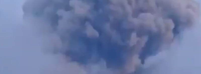
Featured image: Eruption of Mount Agung on March 28, 2019. Credit: Sutopo Purwo Nugroho
Mount Agung in Karangasem regency, Bali, Indonesia erupted at 10:25 UTC on Thursday, March 28, 2019 (18:25 LT). PVMBG maintains alert status at level 3.
The eruption lasted 2 minutes and 32 seconds and ashfall was reported on villages located on the slopes of the volcano.
The Darwin VAAC said volcanic ash reached 5.5 km (18 000 feet) above sea level, drifting NW. The Aviation Color Code remains Orange.
Gunung Agung di Bali erupsi pada 28/3/2019 pukul 18.25 WITA. Terdengar bunyi gemuruh. Hujan abu dan pasir di Banjar Cegi Desa Ban, Temakung Ban.
Status Siaga (level 3). Masyarakat dilarang beraktivitas di dalam radius 4 km dari puncak kawah. Bali tetap aman. Bandara Bali normal. pic.twitter.com/Zbbjt5Gqqn
— Sutopo Purwo Nugroho (@Sutopo_PN) March 28, 2019
The eruption caused panic among villagers and at least 20 families fled their homes and took refuge in the village office, the Jakarta Post reports. However, they have all returned home.
I Gusti Ngurah Rai International Airport officials said Friday airport activities and operations remain normal.
The Center for Volcanology and Geological Disaster Mitigation (PVMBG) maintained the alert status at level three, with the danger zone remaining within a 4-km (2.5 miles) radius from the crater, reminding the public, including tourists, to stay clear of the danger zone.
Geological summary
Symmetrical Agung stratovolcano, Bali's highest and most sacred mountain, towers over the eastern end of the island. The volcano, whose name means "Paramount," rises above the SE caldera rim of neighboring Batur volcano, and the northern and southern flanks of Agung extend to the coast.
The 3142-m-high (10 308 feet) summit contains a steep-walled, 500-m-wide (1 640 feet), 200-m-deep (656 feet) crater. The flank cone Pawon is located low on the SE side.
Only a few eruptions dating back to the early 19th century have been recorded in historical time. The 1963-64 eruption, one of the world's largest of the 20th century, produced voluminous ashfall along with devastating pyroclastic flows and lahars that caused extensive damage and many fatalities. (GVP)
I'm a dedicated researcher, journalist, and editor at The Watchers. With over 20 years of experience in the media industry, I specialize in hard science news, focusing on extreme weather, seismic and volcanic activity, space weather, and astronomy, including near-Earth objects and planetary defense strategies. You can reach me at teo /at/ watchers.news.
Commenting rules and guidelines
We value the thoughts and opinions of our readers and welcome healthy discussions on our website. In order to maintain a respectful and positive community, we ask that all commenters follow these rules.