
Record-breaking rains hit Victoria, Australia
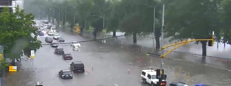
Image credit: VicSES
The moisture from Tropical Cyclone "Owen" is feeding the low-pressure system over Victoria this week, bringing record-breaking rains and floods to the region.
The worst affected were northeast and northwest regions of Victoria, around Birchip, and east of Wangaratta into the Alpine regions, with 201 mm (7.91 inches) registered at Eldorado in 48 hours, 181 mm (7.12 inches) at Banfield Park, 168 mm (6.61 inches) at Birchip.
"Most of the rain at Birchip fell in a 6 hour period Thursday evening, and resulted in quite a bit of flash flooding," said BOM's Senior Meteorologist Peter Newham.
"Few locations recorded daily rainfall records," Newham said. One of those locations is Birchip which recorded 130 mm (5.11 inches) in a 24-hr period, setting its new daily rainfall record for any month. Data records in the region go back to 1889 (129 years), so that's a quite significant event, Newham said.
"Charlton recorded 93 mm (3.66 inches) in a day and that's also an annual daily record. Eldorado had 110 mm (4.33 inches) in a 24-hour period which is a December record for them."
On average, both Birchip and Charlton record just 31 mm (1.22 inches) of December rain. Average rainfall during the month of December at Eldorado is 42 mm (1.65 inches).
In just 30 minutes, the storm dumped almost 34 mm (1.33 inches) in the CBD, of which 27 mm (1.06 inches) fell within 10 minutes.
Remarkable rainfall in the city in the last hour as 37.2mm fell (around 21mm in just 10 minutes!) The storm responsible is now moving away from the city and through the western suburbs.
Check your rainfall totals at: https://t.co/Ur62JM5Fn0 pic.twitter.com/HjwHL24CvT— Bureau of Meteorology, Victoria (@BOM_Vic) December 14, 2018
According to The Age, major roads affected by extreme flash flooding in Melbourne included Dudley Street, Montague Street, Punt Road, Swan Street, Albert Road and Queens Road.
Victoria SES received 533 calls for help by 22:00 LT, December 14, 245 of which were between 17:30 and 18:30.
There were 256 calls for building damage, 22 callouts for people trapped and 36 requests for help for trees down, an SES spokeswoman said.
Seventeen people have been rescued by helicopter and 100 people were stranded in their cars on a flooded Hume Highway in northeast Victoria.
More than 6 000 homes in Melbourne’s south-western suburbs, including in Werribee, Hoppers Crossing and Truganina were left without power as the storm swept through the city. Almost 3 000 homes in Bayside suburbs also experienced outages, but power has since been restored in both areas.
Here's the broadscale view of how the rain fell in the last 24 hours. A deep low moved northwest across western #Victoria wrapping showers, thunderstorms & rain around itself, focussing around Birchip & in the northeast. Check the current warnings at: https://t.co/L0Et41BZyY pic.twitter.com/8Utg6rsIZp
— Bureau of Meteorology, Victoria (@BOM_Vic) December 14, 2018
Check out this video sent in to @9NewsMelb of flooding on Flinders Street! This downpour has been biblical #VicFloods #melbweather pic.twitter.com/rbBSmHLOxQ
— Tom Kelly (@tpwkelly) December 14, 2018
The heaviest rainfall risk today has contracted to southern Victoria, Alpine regions and parts of eastern Victoria and New South Wales, BOM meteorologist Sarah Fitton said.
Buckets of moisture and lots of wind shear are prime ingredients for very dangerous storms through the east again today, with the potential for further heavy rainfall, as well as large hail and damaging winds. And some warnings have already been issued, so keep an eye on the latest developments into the evening.
That severe storm risk also continues for eastern Australia over the weekend, with more warnings likely.
And then, as the low starts to weaken and move south, rainfall will intensify overnight Saturday into Sunday through northern and eastern Tasmania.
Heavy rainfall is most likely in the moist onshore flow in the northeast and some locations could even receive more than 150 mm (5.90 inches).
Flash flooding is a risk, as is minor to moderate flooding across multiple river catchments.
I'm a dedicated researcher, journalist, and editor at The Watchers. With over 20 years of experience in the media industry, I specialize in hard science news, focusing on extreme weather, seismic and volcanic activity, space weather, and astronomy, including near-Earth objects and planetary defense strategies. You can reach me at teo /at/ watchers.news.
Commenting rules and guidelines
We value the thoughts and opinions of our readers and welcome healthy discussions on our website. In order to maintain a respectful and positive community, we ask that all commenters follow these rules.