
Very heavy rain and damaging wind for eastern NSW, Australia
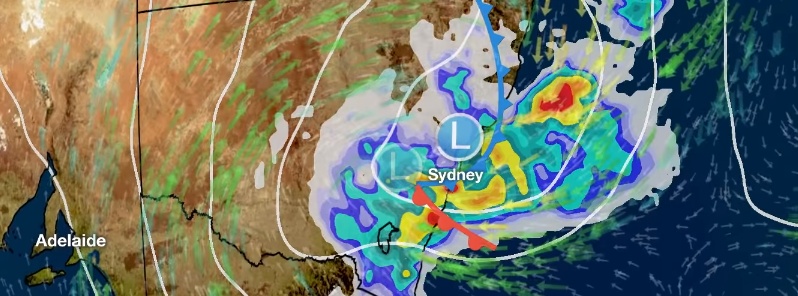
Image credit: BOM
A deepening low pressure system is expected to affect major New South Wales population centers this week. The storm could drop two months of rain over parts of the state, including Sydney, in a matter of hours. Residents are urged to follow advice from local emergency services and keep up to date with the latest warnings and forecasts on the Bureau's website and app.
Heavy rain is expected across coastal areas of the state, most likely in the Sydney and/or Illawarra areas. The rain is expected to begin Wednesday morning, November 28, and continue through the day.
"The low moves off the coast early Wednesday, deepening as it interacts with the ocean," meteorologist Grace Legge said. "As the system strengthens, we'll see significant rainfall wrap around and affect coastal areas."
Heavy rainfall of 50 – 100 mm (2 – 4 inches) is forecast, with isolated falls above 200 mm (8 inches) possible in some areas.
To put this into perspective, Sydney receives an average November rainfall of 66 mm (2.6 inches). With as much as 100 mm (4 inches) of rain expected over the city in a matter of hours, Sydneysiders could see more than a month's worth of rain in just several hours.
Sky News Weather channel meteorologist Rob Sharpe said winds will peak after most of the rainfall has arrived, which means 'the ground will be soggy and a little bit looser, making it easier for trees to come down.'
"This event is likely to lead to flooding, trees and power lines down and therefore we’ll also have power outages with the worst of the weather," he said.
The Sydney metro and Illawarra regions are most likely to see the heaviest falls, which may cause flash flooding, but other districts around them may also be affected. The location of the heaviest rainfall is highly dependent on the convergent bands around the low and where individual thunderstorms form, BOM said.
Due to this significant rainfall, a Flood Watch is current for coastal rivers between the Central Coast and St Georges Basin, where localised minor to moderate riverine flooding may develop from Wednesday.
Rainfall is expected to start easing from late Wednesday, but is not the only hazard associated with this system.
Damaging wind gusts in excess of 90 km/h (55 mph) and hazardous surf conditions are also forecast along the coastal fringe for Wednesday morning, and may extend further along it by the evening.
Winds will ease later on Thursday as the low moves away from the coast, taking much of the weather with it.
BOM urges all residents to follow advice from your local emergency services and keep up to date with the latest warnings and forecasts on the Bureau's website and app.
I'm a dedicated researcher, journalist, and editor at The Watchers. With over 20 years of experience in the media industry, I specialize in hard science news, focusing on extreme weather, seismic and volcanic activity, space weather, and astronomy, including near-Earth objects and planetary defense strategies. You can reach me at teo /at/ watchers.news.
Commenting rules and guidelines
We value the thoughts and opinions of our readers and welcome healthy discussions on our website. In order to maintain a respectful and positive community, we ask that all commenters follow these rules.