
Michael strengthens to a major hurricane, life-threatening storm surge, hurricane-force winds and heavy rainfall expected along the NE Gulf Coast
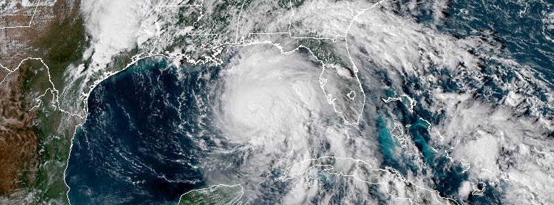
Featured image: Hurricane "Michael" at 20:45 UTC on October 9, 2018. Credit: NOAA/GOES-East
Michael strengthened into a Category 3 hurricane at 21:00 UTC on October 9, 2018. This storm is expected to produce life-threatening storm surge, hurricane-force winds and heavy rainfall along the northeastern Gulf Coast.
A Storm Surge Warning is in effect for Okaloosa/Walton County Line to Anclote River, Florida.
A Storm Surge Watch is in effect for Anclote River to Anna Maria Island, Florida, including Tampa Bay, and Alabama/Florida border to Okaloosa/Walton County Line, Florida.
A Hurricane Warning is in effect for Alabama/Florida border to Suwannee River, Florida.
A Tropical Storm Warning is in effect for Alabama/Florida border to the Mississippi/Alabama border, Suwanee River to Chassahowitzka, Florida, and Fernandina Beach, Florida to South Santee River, South Carolina.
A Tropical Storm Watch is in effect for Chassahowitzka to Anna Maria Island, Florida, including Tampa Bay; Mississippi/Alabama border to the Mouth of the Pearl River; South Santee River South Carolina to Duck, North Carolina; and Pamlico and Albemarle Sounds.
.png)
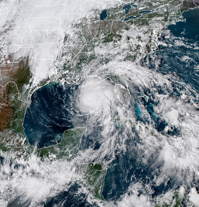
Hurricane "Michael" at 20:45 UTC on October 9, 2018. Credit: NOAA/GOES-East
At 21:00 UTC today, its center was located 470 km (295 miles) S of Panama City and 435 km (270 miles) SSW of Apalachicola, Florida. Maximum sustained winds were 195 km/h (120 mph) and the storm was moving N at 19 km/h (12 mph) with minimum central pressure of 957 hPa.
A northward motion is expected through tonight, followed by a northeastward motion on Wednesday and Thursday, October 10 and 11.
On the forecast track, the center of Michael will move across the eastern Gulf of Mexico through tonight (CDT), move inland over the Florida Panhandle or Florida Big Bend area on Wednesday, northeastward across the southeastern United States Wednesday night and Thursday, and move off the Mid-Atlantic coast away from the United States on Friday.
Some additional strengthening is expected, and Michael is forecast to be a major hurricane at landfall in Florida, NHC warns. Weakening is expected after landfall as Michael moves through the southeastern United States.
Hurricane-force winds extend outward up to 45 miles (75 km) from the center and tropical-storm-force winds extend outward up to 175 miles (280 km).
Hazards affecting land
Storm surge
The combination of a dangerous storm surge and the tide will cause normally dry areas near the coast to be flooded by rising waters moving inland from the shoreline. The water has the potential to reach the following heights above ground if peak surge occurs at the time of high tide:
Mexico Beach, FL to Keaton Beach, FL: 2.7 – 4 m (9 – 13 feet)
Okaloosa/Walton County Line, FL to Mexico Beach, FL: 1.8 – 2.7 m (6 – 9 feet)
Keaton Beach, FL to Cedar Key, FL: 1.8 – 2.7 m (6 – 9 feet)
Cedar Key, FL to Chassahowitzka, FL: 1.2 – 1.8 m (4 – 6 feet)
Chassahowitzka to Anna Maria Island, FL including Tampa Bay: 0.6 – 1.2 m (2 – 4 feet)
Alabama/Florida border to Okaloosa/Walton County Line, FL: 0.6 – 1.2 m (2 – 4 feet)
Wind
Hurricane conditions are expected within the hurricane warning area along the U.S. Gulf Coast by Wednesday, with tropical storm conditions expected by tonight or early Wednesday. Hurricane conditions will also spread well inland across portions of the Florida Panhandle, southeastern Alabama and southwestern Georgia.
Tropical storm conditions are expected in the tropical storm warning area by tonight or early Wednesday and are possible within the tropical storm watch area by that time. Hurricane conditions are possible within the hurricane watch area by Wednesday.
Tropical storm conditions are expected in the warning area along the southeast U.S. coast by Wednesday, and possible in the watch area by late Wednesday.
Rainfall
Michael is expected to produce the following rainfall amounts through Friday, October 12
Western Cuba: an additional 25 – 50 mm (1 to 2 inches).
Florida Panhandle and Big Bend, southeast Alabama, and portions of southwest and central Georgia 102 – 204 mm (4 to 8 inches), with isolated maximum amounts of 305 mm (12 inches). This rainfall could lead to life-threatening flash floods.
The remainder of Georgia, the Carolinas, and southern Virginia 76 – 152 mm (3 to 6 inches), with isolated maximum amounts of 203 mm (8 inches). This rainfall could lead to life-threatening flash floods.
Florida Peninsula, eastern Mid Atlantic, southern New England coast 25 to 75 mm (1 – 3 inches).
Surf
Swells generated by Michael are affecting the coasts of the eastern and northern Gulf of Mexico, and will spread to portions of the northwestern and western Gulf of Mexico coast during the next day or so. These swells are likely to cause life-threatening surf and rip current conditions. Please consult products from your local weather office.
Tornadoes
The threat for tornadoes will increase late tonight into Wednesday over parts of the Florida Panhandle, the northern Florida Peninsula, and southern Georgia.
Forecast models
I'm a dedicated researcher, journalist, and editor at The Watchers. With over 20 years of experience in the media industry, I specialize in hard science news, focusing on extreme weather, seismic and volcanic activity, space weather, and astronomy, including near-Earth objects and planetary defense strategies. You can reach me at teo /at/ watchers.news.
Bah. The real menace is Hurricane Leslie that has been swirling around the Atlantic for a long time now, often changing direction as it has again, now making a swing to the south and, I bet, changing again to go west, ultimately, perhaps, forming into a Pacific-like super, super typhoon that will swamp and sweep the American east coast in a manner not seen in modern history, savagely pounding the US economy. There, you have been warned of a still remote but increasing probability. Beware.