
The Watchers News Brief: October 9, 2018

Image credit: Photo: Studio Świateł - Karolina Toczydłowska. Edit: TW
SE Iran sandstorm injures 145
A total of 145 people asked for medical attention in southeastern Iran's Sistan-Balustan Province on October 7 due to respiratory problems caused by a sandstorm. 27 of them were hospitalized.
The winds in the province reached 104 km/h (64 mph) and the particulates were as high as 19 times the standard.
On the same day, at least 7 people have been killed after extremely heavy rain caused 'unprecedented' flash floods and landslides in northern provinces of Gilan, Mazandaran and Golestan over the past few days. The region experienced worst rains in at least 20 years, officials said.
Officials said an average of 300 mm (11.8 inches) fell on Mazandaran in just 24 hours, causing floods in which hundreds of people were trapped and at least 7 killed. Average rainfall for the month of October in Sari, Mazandaran is less than 80 mm (3.1 inches). The annual average is 690 mm (27.1 inches).
Over 300 houses were flooded, numerous roads, bridges and other infrastructure destroyed and power lines, natural gas and water pipes affected. Many cars were stuck in floodwaters, prompting numerous water rescues.
Heavy rain, floods and landslides leave 9 people dead, 5 000 displaced in Sri Lanka
At least 9 people have been killed and 5 000 displaced after severe storms dropped heavy rain, causing floods and landslides.
According to Sri Lanka’s Disaster Management Centre (DMC), 4 people have died in floods in the district of Kalutara, 2 in Galle and 2 in Rathnapura. One person died after strong winds downed trees in Kegalle district.
A total of 5 834 people from 1 318 families are currently displaced and staying in 21 temporary relocation centers in the districts of Colombo (5 654 people), Kalutara (58) and Nuwara Eliya (122), FloodList reports.
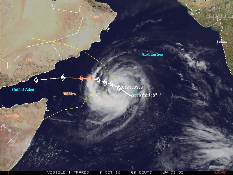
Tropical Storm "Luban" forms in the Arabian Sea
Tropical Cyclone "Luban" formed over the Arabian Sea on October 8 and started moving north-west toward southwestern Oman as a tropical storm.
At 00:00 UTC on October 8, its center was located 1 000 km (620 miles) south-east from the city of Salalah (Oman) and 860 km (534 miles) southeast from the island of Socotra (Yemen) and it had maximum sustained winds of 65 km/h (40 mph).
Over the next 24 hours, it is forecast to keep moving north-west slightly strengthening but remaining as a tropical storm.
USGS: Hurricane "Michael" surge likely to erode 75% of Florida Panhandle beaches
Hurricane "Michael," which is forecast to make landfall Wednesday, October 10 as a Category Three hurricane, is very likely to cause erosion at the base of sand dunes along about three-fourths of the Florida Panhandle beaches, and to inundate more than one-fourth of that coast’s dunes, causing flooding behind the protective dune line, according to coastal change experts at the U.S. Geological Survey.
If the hurricane, which was a Category Two early Tuesday, intensifies and stays on the course forecast by the National Hurricane Center, storm surge impacts are likely to be most severe in the Panhandle region east of the eye, where surge- and wave-induced water levels could rise 5 – 6 m (16 to 20 feet), the USGS predicted.
In west Florida, the beaches of Pinellas and Manatee counties are also vulnerable to beach erosion. About four-fifths of that area’s beaches are very likely to encounter erosion at the base of the dune. But dune inundation is predicted to be less extensive along the state’s west coast. About one-sixth of Alabama’s beaches are also very likely to be eroded by storm waves from the hurricane.

Michael strengthened into a Category 3 hurricane at 21:00 UTC on October 9, 2018. This storm is expected to produce life-threatening storm surge, hurricane-force winds and heavy rainfall along the northeastern Gulf Coast.
Arizonans wake up to snow in the north and wet ground, gray skies in the Valley
Flash flood watches were issued for parts of northern Arizona on October 7. Those showers continued overnight and mingled with a cold front, dropping temperatures and turning rain into snow.
The National Weather Service in Flagstaff measured up to 152 mm (6 inches) of rain at Snowbowl. In addition, 25 mm (1 inch) in Bellemont and 50 mm (2 inches) in Williams.
The Arizona Department of Transportation says to be careful driving up north Sunday morning there is lots of snow and slick roads. Snow accumulated on State Route 87 north of Payson near Clints Well.
That cold front triggered showers and thunderstorms in the Valley too. Just before 07:00 LT, the National Weather Service in Phoenix said that showers from midnight on already broke the daily rainfall record for October 7. NWS measured 10.4 mm (0.41 inches) of rain. The previous record was 7.62 mm (0.30 inches) and was set in 1924.
This month is the third wettest Phoenix October on record.
Deadly floods and landslides after torrential rain hits Central America
Heavy rain produced by two low pressure systems along Central America and the Caribbean affected Central American countries over the weekend, resulting in flash floods and mudslides across western Nicaragua, Honduras, El Salvador, Costa Rica and the coast of Guatemala.
At least 11 people have been killed and two are still missing, authorities said.
In Honduras, 4 people died, 7 013 have been affected, 3 019 evacuated and 2 746 people are housed in temporary shelters.
4 people were also killed in In Nicaragua, 13 000 are affected and 2 880 are in shelters. One person was killed in Costa Rica, 125 190 people are affected and 2 793 people are located in 28 shelters.

TD 14 (soon to become Tropical Storm "Michael") on October 7, 2018. Credit: NOAA/GOES-East
Non-tropical cyclone to affect Madeira and the Canary Islands this week
A shallow cyclone, designated #92L has developed midway between the Azores and the Canary Islands this past weekend, SWE meteorologists report.
It is currently located just west of Madeira island, gradually moving east. This cyclone does not have tropical characteristics, but consists of widespread thunderstorms which could potentially result in flash floods across Madeira and possibly parts of the Canary Islands in the next few days.
Hurricane "Leslie" on its way towards west-southwest Europe this week
Tropical Storm "Leslie" is near hurricane strength again, expected to become a hurricane by the end of October 9 or during October 10.
"Unfortunately the track forecast has not become any clearer," NHC forecaster Zelinsky said.
"Recent GFS and ECMWF ensemble forecasts still indicate that a range of possibilities exist, from Leslie becoming extratropical and heading toward the extreme northeast Atlantic, to Leslie turning back west in a few days and persisting as a tropical cyclone. No large changes were made to the track forecast at this time, since I see no reason to commit to a new solution at this time. The NHC forecast is close to HCCA at all forecast hours, but confidence is low to say the least."

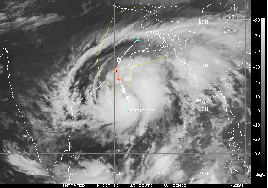
Cyclonic Storm "Titli" forms in Bay of Bengal, flooding rainfall, strong winds expected in eastern India, Bangladesh
Cyclonic Storm "Titli" formed October 9 and will bring dangerous weather to parts of India and Bangladesh in the coming days.
Titli is forecast to continue strengthening as it tracks northwest toward the east coast of India during the next 24 to 48 hours.
Locations at risk for impacts include Visakhapatnam, Brahmapur, Puri, Kharagpur and Kolkata in India; and Dhaka, Khulna and Chittagong in Bangladesh.
First snow storm coming to Northwestern Ontario
First snowstorm of the season is expected to hit Northwestern Ontario on Wednesday and Thursday, October 10 and 11.
Special weather statement in effect for:
- Dryden – Vermilion Bay
- Ignace – English River
- Atikokan – Shebandowan – Quetico Park
- Upsala – Raith
- Fort Frances – Emo – Rainy River
- Seine River Village – Mine Centre
As the low-pressure system gets closer, northeast winds will pull down colder air from the Arctic, causing temperatures to drop to near or below freezing Tuesday night, October 9, resulting in a changeover to snow.
Latest indications continue to suggest that 15 to 25 cm (5.9 – 9.8 feet) of snow may fall across the region Wednesday into Thursday. While there is still some uncertainty with the exact location of the heavy snow, it appears areas near a line from Fort Frances to just north of Lake Nipigon have the greatest chance of receiving the highest snowfall accumulations. This snowstorm may have quite an impact on transportation.
Storm "Callum" – serious weather event expected in Ireland by the end of the week
Storm "Callum" is on track to hit Ireland on October 11 and 12.
"Overnight charts continue to show a serious storm Thursday night into Friday with damaging gusts. Some charts continue to show gusts of over 130 km/h (81 mph) on the West coast and over 110 km/h (68 mph) widely," said Alan O'Reilly of Carlow Weather.
Tornadoes and waterspouts reported across Italy
A number of tornadoes were reported across much of Italy on October 6. The south of Italy was under a moderate mid-level jetstream, overlapping with moderate instability, SWE meteorologists said.
Up to 1000-1500 J/kg MLCAPE was in place around Sicily, Campania and Puglia. Conditions were generally supportive for supercell thunderstorms and tornadoes. A spectacular tornadic supercell formed off the coast of Favignana island, Sicily.
Two dead, one missing as Typhoon "Kong-rey" hits south Korea
Two people died and one person is missing in South Korea as powerful Typhoon "Kong-rey" hit the country on October 6, the government said.
A 66-year-old man died while crossing a bridge in the city of Gwangju, south of Seoul, the national disaster management agency said without elaborating on the cause of the death. Another man, aged 83, was found dead after being washed away by a river in a southern county of Yeongdeok, while a 76-year-old went missing after falling into a river in the southern port of Pohang. The powerful typhoon dumped heavy rain across the country before moving away from the peninsula on October 7.
150 evacuated due to rockslide risks in Haldummulla, Sri Lanka
Downpours exceeding 100 mm (3.9 inches) in several areas belonging to Haldummulla Divisional Secretariat in Badulla District have heightened the risk of rockslides, says the Badulla District Additional Director of Disaster Management Center E.L.M Udayakumara.
Accordingly, 150 people of 43 families in the Bathgoda area of Beragala Grama Niladhari Division were evacuated to Chulananda Tamil Vidyalaya at around 20:00 LT, October 4.
Rockslope failure at Shongtong in northern India
The video was recorded by a group of workers at a new hydroelectric facility at Shongtong Karcham in Kinnaur.
"This will be a 450 kW run of the river scheme generating an estimated 450 MW, reportedly enough to power 800 000 households," Dr. Dave Petley reports.
"This is another scheme being constructed in an area with high landslide potential. There is an interesting article on Himdhara about the environmental impact of these major construction projects in the Kinnaur area, which includes a section on the impact of this scheme."
Winter arrives early in Himachal Pradesh, India
With some parts of upper Himachal receiving several spells of snowfall and high altitude lakes getting frozen completely, the winter this year has arrived at least a month in advance, pointing to the possibility of good snowfall and harsh cold in the coming months.
Upper regions of Kullu, Kinnaur and Chamba districts and entire Lahaul valley have been covered in white blanket of snow. Lahaul valley had seen heavy snowfall in September for the first time in decades.
Rohtang pass, Baralacha pass, Kunzum pass and all major passes in these districts are covered with snow. The peaks have been witnessing frequent spells of snowfall since early September. While lower parts of Himachal are dry, peaks here are receiving more snow. Although peaks receiving snow in September is not new in Himachal, but people had not seen such a heavy snowfall in the month.
Preliminary survey indicates poor monsoon led to nearly 70% crop loss in Jodhpur, India
Approximately 70% crops sown in Rajasthan's Jodhpur district failed due to poor monsoon, according to a preliminary survey conducted by the agriculture department.
The threat of drought looms large in western Rajasthan with the region reporting below average rainfall dampening the hopes of farmers.
"Approximately 70 percent of crops sown in the district in non-irrigated areas have failed," Deputy Director (Agriculture) B K Dwivedi said. The actual loss can be assessed after getting detailed report on crop failure by the revenue department."
Cape Town dams still 76.2% full, despite the city’s recent ‘heat wave’
The Cape Town dams have plateaued at 76% full, following limited rainfall in recent weeks and high temperatures sweeping over the Mother City. The dam levels have done well to retain their previous weekly percentage, considering temperatures over the weekend rose to above 30 °C (86 °F). With little cloud cover, evaporation was expected to suck up more water than it actually did. This is good news for Capetonians.
BOM season outlook predicts fewer tropical cyclones than normal
"Indications are for a lower-than-average number of tropical cyclones, and we are less likely to have widespread flooding," said Bruce Gunn, the state manager of BOM Queensland.
"We are heading into what should be a warmer and dryer season ahead, which means a longer bushfire season, that's already upon us, an increased chance of heatwaves, continuing drought, unfortunately, and also an increased chance of coral bleaching," Mr Gunn said.
"It only takes one tropical cyclone to make a season, just like we saw with Tropical Cyclone Debbie."
Sprites above thunderstorms over the northern Adriatic S
Czech upper atmosphere lightning observer Martin Popek reports sprites above the thunderstorms over the northern Adriatic Sea on October 6 and 7, 2018.
The Palu landslides – the worst landslide disaster in five years?
"Based on reports from the (village) heads of Balaroa and Petobo, there are about 5 000 people who have not been found," BNPB's Sutopo Purwo Nugroho said, referring to M7.5 earthquake and tsunami that hit Indonesian island of Sulawesi on September 28. "Nevertheless, officials there are still trying to confirm this and are gathering data. It is not easy to obtain the exact number of those trapped by landslides, or liquefaction, or mud.”
"Given the scale of the Palu landslides, and the very high number of houses involved, this level of loss is entirely possible," Dr. Dave Petley said.
"It is clear from the videos that the flow was highly mobile, which will have made escape from the crush of houses and debris extremely challenging, especially in a dense network of streets. The mobility of the debris will have meant that buildings will have filled with mud, even where there were voids that might have protected a person. It is therefore unsurprising that no survivors have now been recovered in a week."
Massive sinkhole swallows 4 pedestrians In China
A pavement collapsed in Dazhou city, Sichuan province in central China on October 7, giving way to a massive sink hole that swallowed four pedestrians.
People’s Daily China confirmed one of the four casualties was confirmed dead while the extent of injuries of the rest of them was not immediately known. The Chinese news outlet also posted a video which showed the exact moment the sinkhole opened up and caused the four people to fall in it.
The sinkhole was formed when a large portion of a tiled pavement outside a local hospital gave way. Unsuspecting people who were walking on the busy commercial part of Dazhou were swallowed by the sinkhole in a matter of seconds. All of them were rescued by emergency staff and taken to a hospital, South China Morning Post reported.
Watch the terrifying moment a large sinkhole appeared on a sidewalk in Dazhou, SW China's Sichuan, on Sunday, swallowing 4 people, one of whom has been confirmed dead. Rescue operations are still underway, according to local media reports. pic.twitter.com/qYQ4ba5rnx
— People's Daily,China (@PDChina) October 8, 2018
The Barren Island volcano has begun to spew lava and ash, India
The Barren Island volcano, India's only active volcano, in the Andaman and Nicobar Islands has begun to spew lava and ash. Geologists observe that the eruption could be linked to the recent earthquake that rocked Indonesia.
According to officials from the Geological Survey of India (GSI), the eruption was first recorded on September 25 when satellite images confirmed the spewing of lava or pyroclastic material and ash on the north flank of the island.
"There have been many cases of volcanic eruptions which were preceded by earthquakes of mild intensity. They could be linked, and the source of trigger may be the same, as the location of Sulawesi earthquake is not very far away. But it may also be separate and simultaneous events and the source may be different. Only a detailed field study can reveal the cause of the eruption," said Tapan Pal, director, PSS, GSI, northeast region.
Anak Krakatau erupts 407 times in 24 hours, Indonesia
Anak Krakatau has erupted 407 times and spewed lava in 24 hours to October 7.
The eruption was heard and trembling felt at the Mount Krakatau observation post, according to Jumono, the post`s officer, as quoted by the Meteorology, Climatology and Geophysics Agency (BMKG) in a statement on Sunday.
The observation post recorded a total of 407 seismic eruptions with amplitude of 30-50 mm, duration of 37-300 seconds; 14 harmonic tremors with amplitude of 10-41 mm, duration of 34-123 seconds; and incessant tremors with amplitude of 2-40 mm, and dominant of 20 mm.
Eruption on Saunders Island
A fresh ash fallout is present on the northwest flank of Mount Michael on Saunders Island in a Landsat 8 satellite image from September 28, 2018. This is a sign that an eruption had recently occurred on this volcano sometime between September 23 and 28.
After studying satellite images on the EOSDIS Worldview website, it is most likely that the eruption occurred on September 27, 2018 based on the wind direction going northwest.

Strong lahars descend down Fuego volcano, Guatemala
Strong lahars were reported descending down Guatemala's Fuego volcano on October 6:
VOLCÁN DE FUEGO: Fuertes lahares descienden a esta hora por la barranca Ceniza, los mismos son generados por la actual lluvia que se presenta en este complejo volcánico, se mantienen monitoreos en comunidades cercanas.
Fuente: William Chigna, Técnico de la UPV de la CONRED. pic.twitter.com/WBhwhuaQxK— CONRED (@ConredGuatemala) October 6, 2018
CONRED INFORMA: Se monitorea el incremento en la actividad del volcán de Fuego.
Fuente: INSIVUMEH. #PrevenirParaVivir pic.twitter.com/ijKIc1mdzW— CONRED (@ConredGuatemala) October 6, 2018
Important eruption at Turrialba, Costa Rica
Cameras located at the Turrialba Volcano National Park caught the moment it registered an important eruption on October 5. During the eruption, incandescent material was expelled.
The National Seismology Network reminds the public of the dangers they expose themselves to if they venture to climb the restricted area near the crater of the volcano.
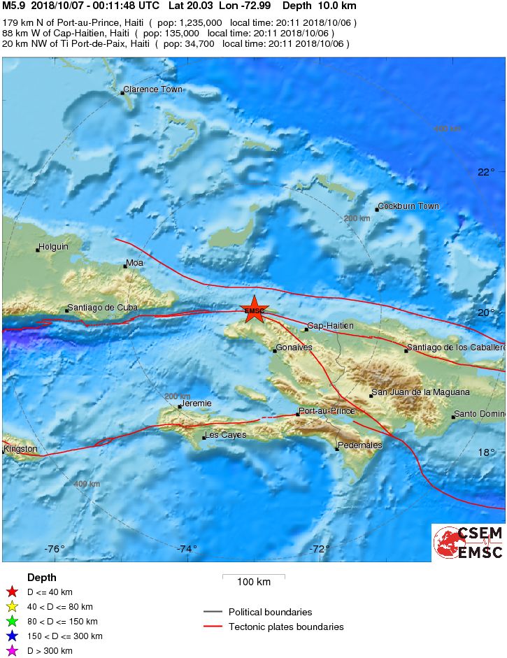
Deadly M5.9 earthquake hits Haiti
A strong and shallow earthquake registered by the USGS as M5.9 hit Nord-Ouest, Haiti at 00:11 UTC on October 7, 2018 (20:12 local time, October 6).
At least 15 people have been killed and 300 injured. 40 homes have been destroyed.
This is the poorest part of the country, with many isolated areas due to bad road infrastructure.
CH HSS sparks geogmagnetic storm
Earth was under the influence of a positive polarity coronal hole high speed stream (CH HSS) on October 7 and 8, 2018. G1 – Minor geomagnetic storm conditions were observed at 16:22 UTC and 20:42 UTC on October 7, 2018. A G2 warning has been issued and is valid until 06:00 UTC and G1 until 09:00 UTC on October 8.
Fuel spill in the Mediterranean after ships collide near Corsica
Two merchant ships collided north of the French island of Corsica on October 7, causing a 4-kilometer (2.4 mile) fuel spill in the Mediterranean Sea that French and Italian authorities are working to contain.
No one was injured, but it smashed a hole of several meters long in the hull of one of the ships, causing the spill, according to a statement from the regional French maritime authority. The spill is several hundred meters wide, heading away from Corsica to the northwest, toward the French and Italian mainland, the statement said.
A spokesman for the regional French maritime authority described the material as 'propulsion fuel' without elaborating.
Pilgrim nuclear power plant experiences unplanned shutdown, Massachusetts
The Pilgrim Nuclear Power Station experienced an unplanned shutdown, known as a 'scram,' at 12:09 LT, October 6, according to the Nuclear Regulatory Commission.
The shutdown occurred when a feedwater regulating valve unexpectedly closed, resulting in a drop in the reactor’s water level. That initiated the protection system and shutdown, which involves the insertion of all control rods into the nuclear core to halt the fissioning process, according to an email sent by NRC spokesman Neil Sheehan.
All reactor safety systems functioned as designed and the shutdown was carried out without complications, according to Sheehan.
I'm a dedicated researcher, journalist, and editor at The Watchers. With over 20 years of experience in the media industry, I specialize in hard science news, focusing on extreme weather, seismic and volcanic activity, space weather, and astronomy, including near-Earth objects and planetary defense strategies. You can reach me at teo /at/ watchers.news.
Commenting rules and guidelines
We value the thoughts and opinions of our readers and welcome healthy discussions on our website. In order to maintain a respectful and positive community, we ask that all commenters follow these rules.