
The Watchers News Brief: September 28, 2018

Image credit: Sutopo Purwo Nugroho. Edit: TW
Powerful M7.5 earthquake hits Sulawesi, causing major tsunami in Palu and Donggala – more than 50 dead
A powerful earthquake registered as M7.5 by the USGS and M7.7 by the BMKG hit Sulawesi, Indonesia at 10:02 UTC on September 28, causing a major tsunami in Palu and Donggala. It was 17:02 in Indonesia at the time.
Official sources mention tsunami waves up to 3 meters (10 feet) but there are reports speaking of a tsunami as high as 6 m (20 feet).
Authorities are still assessing the damage and counting casualties. As of 22:00 UTC, September 28, at least 7 people have been killed. By 06:00 UTC on September 29, the number rose to at least 48 and authorities warned the death toll may substantially rise in the coming days.
Electricity and communications in tsunami-affected areas have been cut off, making it difficult to assess the damage.
Residents are urged not to go inside their homes and sleep away from buildings.
Updates will be posted here.
Analisis sementara ahli tsunami dsri ITB berdasarkan modeling dan kajian sebelumnya bahwa tsunami di Palu disebabkan adanya longsoran bawah laut saat gempa 7,7 SR mengguncang Donggala. Teluk Palu dan pesisir Donggala memang rawan tsunami. Masih dilakukan kajian lagi. pic.twitter.com/1YbHEFmTfT
— Sutopo Purwo Nugroho (@Sutopo_PN) September 29, 2018
Detik-detik saat tsunami menerjang Pantai Palu pada 28/9/2018 sore pascagempa 7,7 SR mengguncang Donggala. Tinggi tsunami sekitar 3 meter. Permukiman di sekitar pantai hancur disapu tsunami. pic.twitter.com/GnxecozDKk
— Sutopo Purwo Nugroho (@Sutopo_PN) September 28, 2018
Medicane "Cindy" (Zorbas, Zorba) heading toward southern Greece
A high risk has been issued for extreme southern Greece into northern Aegean Sewa and NW Turkey with a threat for torrential and excessive rainfall, severe damaging winds and tornadoes, SWE meteorologists report in their special Outlook.
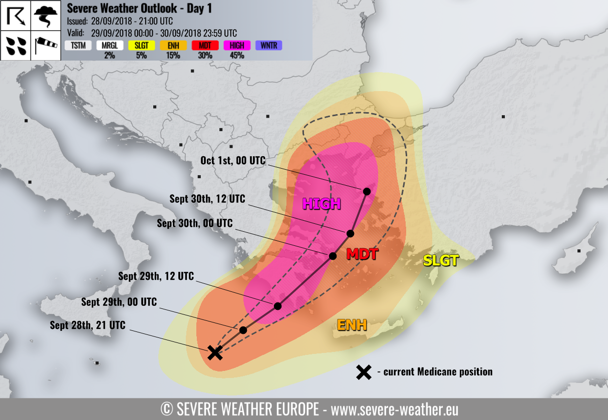
HIGH risk has been issued for extreme southern Greece (Peloponnese, Attica, N Cyclades) into northern Aegean sea and NW Turkey with threat for torrential and excessive rainfall, severe damaging winds and tornadoes. The area highlights the highest risk for potentially destructive flooding associated with the track of the Medicane where rainfall accumulation could exceed 250 – 300 mm (9.8 – 11.8 inches) in a 36 – 48 hour period. Severe winds will be associated along the trailing cyclone’s inner core storms while enhanced potential for tornadic supercells exists across the Attica region and Aegean sea where strongly enhanced shear and helicity greatly overlap with strong instability.
MDT risk has been issued for surrounding areas of HIGH risk across south Greece, Cyclades, Aegean Sea, northeast Greece into northwest Turkey and extreme south Bulgaria with threat for severe winds and excessive rainfall. Here, less robust threat is expected and it critically depends on the Medicane’s center track.
ENH/SLGT risks have been issued for surrounding areas of HIGH/MDT risks including Crete island, Rhodes, west-southwest Turkey and southeast Bulgaria with threat for severe winds, excessive rainfall and isolated severe storms possible.
More information, satellite images and forecast models can be found here.
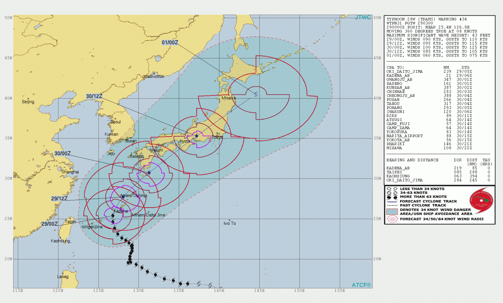
Typhoon "Trami" over Okinawa, heading toward mainland Japan
Typhoon "Trami" continued tracking northeast toward Okinawa Island (Okinawa prefecture, Japan) on September 29.
It is forecast to pass close or over Okinawa Island during early morning UTC hours of September 29. Heavy rain, strong winds and storm surge may affect the Ryuku Islands and Kyushu and Shikoku Islands, as well as north-eastern Taiwan through September 30.
Japan Meteorological Agency has issued, as of September 28, a warning for storms and high waves for Okinawa and Amami Islands and for Kyushu Island. The Central Weather Bureau of Taiwan has also issued a warning for extremely heavy rain for northern counties.
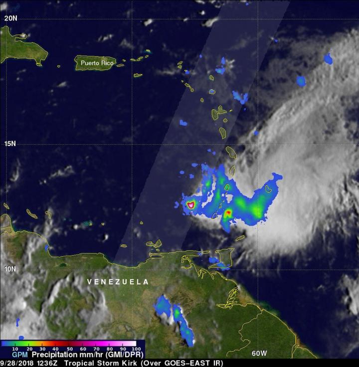
Tropical Storm "Kirk" moves over Barbados and the Lesser Antilles, dissipates
Tropical Storm "Kirk" weakened as it pushed westward into the Caribbean on September 28 with strong winds and heavy rains hammering Barbados and the Lesser Antilles. The storm dissipated later in the day and Kirk became an open wave over the eastern Caribbean Sea.
Up to 253 mm (10 inches) of rain fell across parts of Barbados in less than 15 hours, according to data obtained from the met office at Barbados Airport.
Flash floods leave 2 dead in Vargas, Venezuela
Heavy rain hit parts of the state of Vargas on September 25, turning streets into raging rivers. According to local media reports, 2 young girls died after rain and flooding triggered a landslide that caused a building to collapse in the Cabreria neighborhood of La Guaira.
Heavy rain also caused flooding in border areas between Vargas and Aragua states, FloodList reports. The Maya River broke its banks in Puerto Maya in Tovar municipality, Aragua state, leaving around 1,000 people cut off. Residents were able to move to higher ground and no fatalities have been reported.
via @karinamm154: Fuertes lluvias causan estragos en el estado #Vargas… esto sucedió en la Calle Real de Montesano.#Venezuela pic.twitter.com/k7GeHWU0DM
— traffic VARGAS (@trafficVARGAS) September 26, 2018
#Venezuela #RT : Fuerte Lluvia #LaGuaira #Maiquetia .@trafficVARGAS. Lluvias intensas desde hace 1 Hora corrida. Tráfico Trancado. pic.twitter.com/LH2CDtkPmk
— WilfredoParraE (@YV2GFI) September 25, 2018
Florence update: Agricultural damage in North Carolina at least $1.1bn, NCDA
Initial estimates for crop damage and livestock losses to North Carolina’s agriculture industry are expected to be over $1.1 billion, based on assessments following Hurricane "Florence." That number easily tops the $400 million seen following Hurricane "Matthew" in 2016.
"We knew the losses would be significant because it was harvest time for so many of our major crops and the storm hit our top six agricultural counties especially hard," said Agriculture Commissioner Steve Troxler. "These early estimates show just what a devastating and staggering blow this hurricane leveled at our agriculture industry."
Following are estimates by crops:
Row crop losses are estimated at $986.6 million
Forestry losses are estimated at $69.6 million
Green industry losses are estimated at $30 million
Vegetable and horticulture crop losses are estimated at $26.8 million
Livestock, poultry and aquaculture losses are estimated at $23.1 million
Livestock losses are 4.1 million poultry and an estimate of 5,500 hogs.
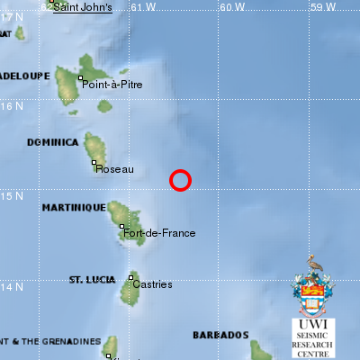
Strong and shallow M5.6 earthquake hits near the coast of Martinique and Dominica
UWI/SRC registered the quake at 12:32 UTC (08:32 local time) 91 km (56 miles) NE of Fort-de-France, Martinique, 108 km (67 miles) ESE of Roseau, Dominica and 134 km (83 miles) NE of Castries, Saint Lucia at a depth of 10 km (6.2 miles).
The USGS registered it as M5.4 at a depth of 37.7 km (23.4 miles).
Potential eruption at Barren Island, India
#volcan #volcano #BarrenIsland #India Une activité éruptive semble avoir démarré/An eruption seems to have begun pic.twitter.com/apECxuKxwP
— CultureVolcan (@CultureVolcan) September 28, 2018
Unrest continues at Semisopochnoi volcano, western Aleutians
Unrest continues at Semisopochnoi volcano, AVO reports.
Intermittent seismic tremor has been detected on local seismic stations throughout the week. Early in the week, several of the most energetic seismic signals also produced signals detected on the Adak infrasound array located 257 km (159.5 miles) east of Semisopochnoi.
These events were likely short-lived explosions, but produced no ash detectable in satellite imagery or reported by passing pilots. Cloudy conditions throughout the week have limited our ability to view the island and substantiate eruptive activity.
The September 10 ash deposit indicates the potential for ash emissions coincident with the ongoing elevated seismicity. Thus Semisopochnoi volcano's status remains at ORANGE/WATCH.
Veniaminof continues erupting, feeding a lava flow, Alaska
Veniaminof continues to erupt, feeding a lava flow that extends at least 900 m (0.56 mi) down the south flank of its summit cone.
Midweek, pilots reported lava fountaining and associated minor ash emissions that may have reached up to 4570 m (15 000 feet) asl, but quickly dispersed downwind. No significant ash emissions have been detected in satellite imagery or reported in nearby communities. An FAA web camera in Perryville recorded incandescence at night throughout the week, when visibility was good, and a gas plume has been occasionally visible during clear daytime conditions.
Airwaves generated by small explosions during lava fountaining were recorded intermittently on seismic and infrasound stations up to 325 km (200 mi) away from Veniaminof when atmospheric conditions were favorable.
Satellite data have shown elevated surface temperatures throughout the week, and seismicity remains elevated with continuous tremor being recorded locally.
Elevated surface temperatures at Cleveland volcano, central Aleutians
Moderate to weakly elevated surface temperatures in the summit crater of Cleveland volcano were observed in satellite thermal data throughout the week.
Satellite observations from September 20th suggested that the small collapse crater in the center of the summit dome emplaced over the summer was beginning to inflate, but no clear evidence of new lava emplacement has been detected since. No significant activity was detected in seismic and infrasound (pressure) sensor data.
Future explosive activity is likely and is expected to occur without warning. Previous explosions have produced hazardous conditions primarily near the volcano, but occasionally they have been large enough to produce a drifting ash cloud.
Cholera outbreak in transboundary zone – Dominican Republic/Haiti
The Haitian and Dominican health authorities completed a joint mission in response to the cholera outbreak in the Cornillon/Independencia border zone. They have resolved to develop planned interventions to cope with the epidemic, and to strengthen institutions and health networks along the border.
The Haitian Ministry of Public Health reported 3 062 suspected cases of cholera between January 1 and September 1 in Haiti, of which 42% tested positive.
Following a request for assistance from local health authorities in the Dominican Republic, the IFRC has developed a response plan targeting 7 500 people, which DG ECHO is supporting through its Disaster Relief Emergency Fund (DREF).
I'm a dedicated researcher, journalist, and editor at The Watchers. With over 20 years of experience in the media industry, I specialize in hard science news, focusing on extreme weather, seismic and volcanic activity, space weather, and astronomy, including near-Earth objects and planetary defense strategies. You can reach me at teo /at/ watchers.news.
Commenting rules and guidelines
We value the thoughts and opinions of our readers and welcome healthy discussions on our website. In order to maintain a respectful and positive community, we ask that all commenters follow these rules.