
The Watchers News Brief: September 26, 2018
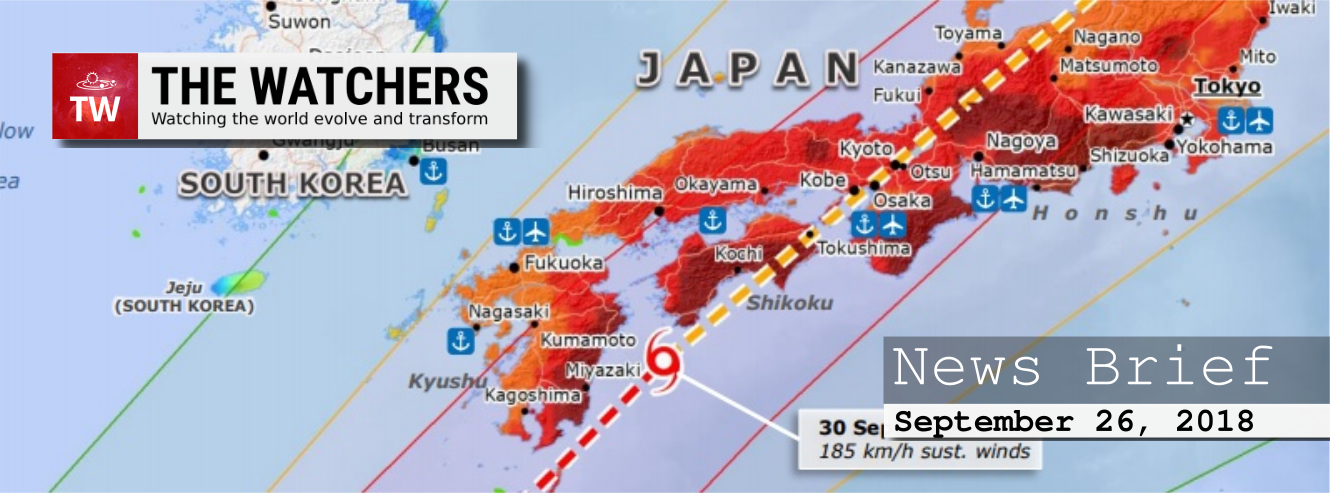
Image credit: ECHO. Edit: TW
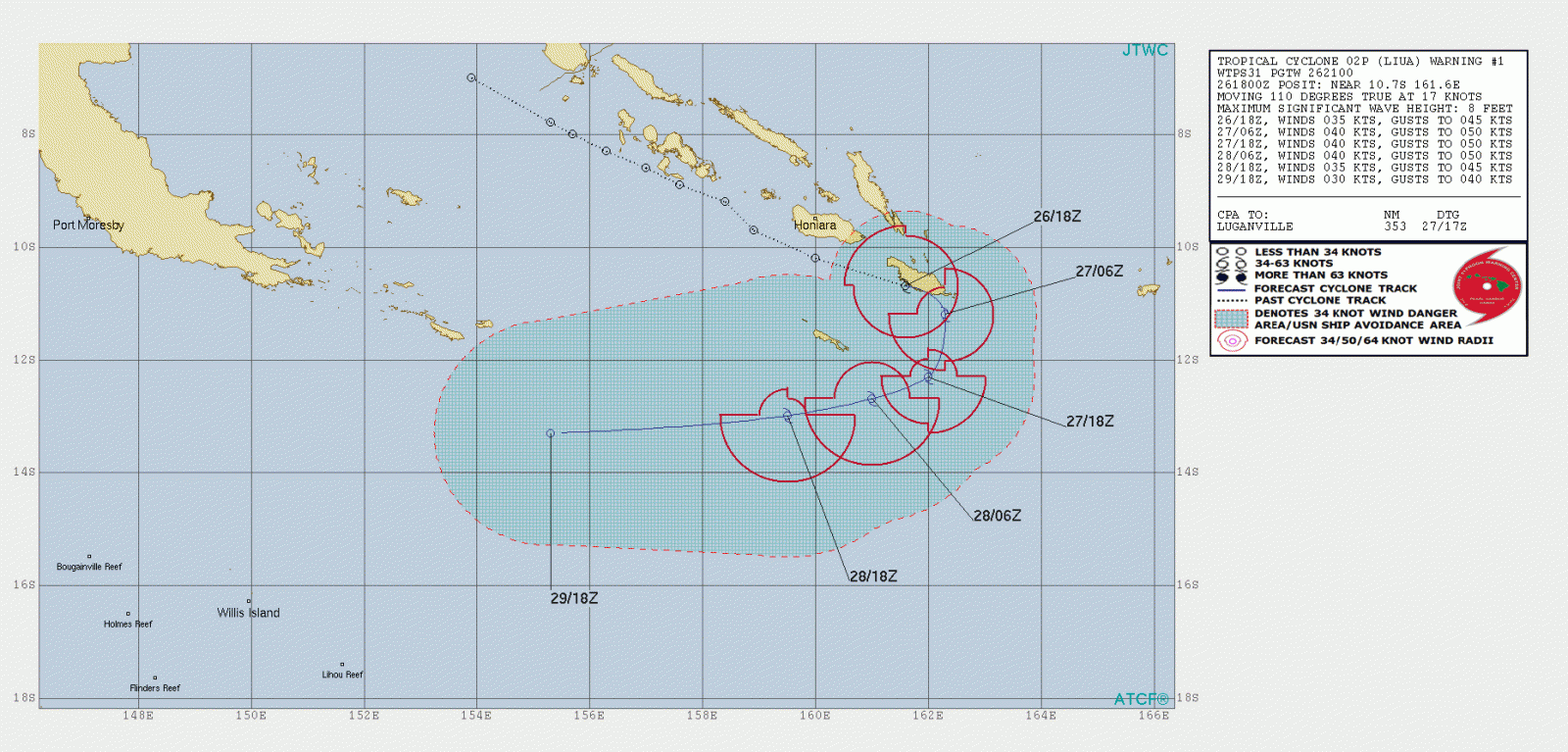
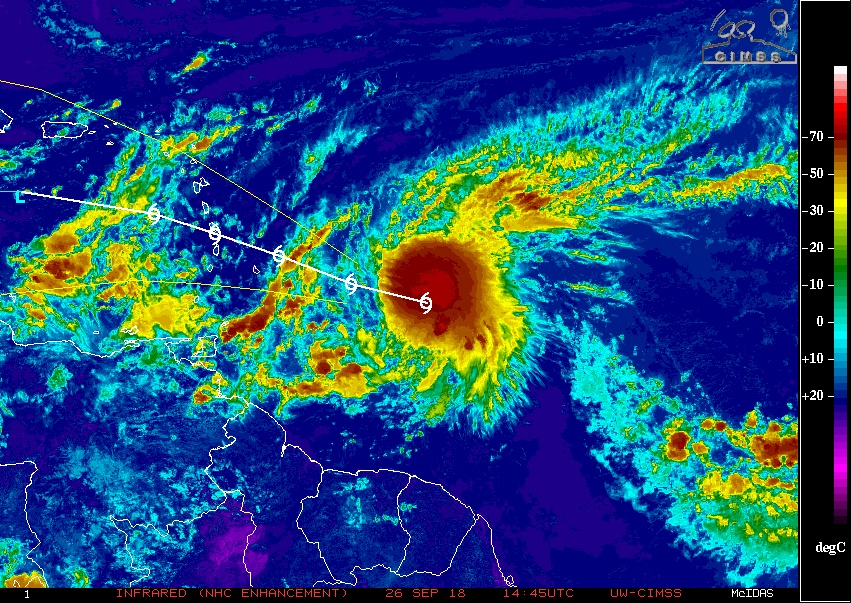
Tropical Cyclone "Liua" forms in Southwest Pacific, first September TC to form in the basin since 1950
Tropical Cyclone "Liua" has formed in the Southwest Pacific on September 26, 2018. This is the first named storm of the 2018/19 South Pacific cyclone season. The season officially runs from November 1 to April 30.
This also is the first tropical cyclone to form during the month of September in the Southwest Pacific since Tropical Cyclone 02P on September 12, 1950 or in 68 years.
Tropical Cyclone #Liua has formed in the Southwest Pacific near the southern Soloman Islands
This is the first TC to form during the month of September in the SW Pacific since Tropical Cyclone 02P on 12 Sep 1950 or in 68 years! [data: IBTrACS] pic.twitter.com/JRnWBw2hVO
— NIWA Weather (@NiwaWeather) September 26, 2018
Severe thunderstorms hit Illinois, downing trees and power lines
As many as 65 000 ComEd customers in Illinois lost power on September 25 after a powerful thunderstorm swept through the region, downing trees and power lines. Weather stations registered winds as high as 112 km/h (70 mph).
There were 73 flights canceled at O'Hare International Airport shortly before 18:00 LT, and arriving flights were delayed by an average of 47 minutes. Twenty-three flights had been canceled at Midway Airport.
"From the scattered reports we’re getting, it looks like we have eight homes in Huntley that were affected, about a half a dozen in Lake in the Hills, one in Algonquin and a few in Cary," said David Christensen, director of the McHenry County Emergency Management Agency.
All of the homes were damaged by falling trees, but only one home in Huntley was rendered uninhabitable, he said.
There have been no reports of injury or death caused by the storm
Short video of the severe thunderstorm coming through Huntley around 4:48p. Strong winds and rain lasted 5-6 min. Way stronger than the usual stuff we get around here. #ilwx pic.twitter.com/qlrYvxZMKy
— Dave DiVenere (@DDivenere) September 25, 2018
Intense thunderstorms cause a massive power outage in Ukraine, 205 cities and villages affected
Intense thunderstorms hit parts of Ukraine on September 25, downing hundreds of trees, causing travel disruption and killing at least one person.
The storm affected seven regions in western, central, southern and northern Ukraine, leaving 205 cities and villages without power.
One person was killed after being hit by a falling tree branch while a woman was injured after a tree hit her car.
Possible tornadoes leave damage in southeast Michigan
A powerful storm and at least one confirmed tornado moved through parts of Frenchtown Township in Monroe County on Tuesday night, September 2, causing heavy damage to trees and infrastructure.
"It was over in less than a minute," one eyewitness told ClickOnDetroid, describing the tornado in Monroe County. "I mean, it really was. It was a big bang, then it was gone. You see the devastation, I mean, it's pretty crazy how fast it hit."
Another potential tornado moved through parts of Gibraltar in Wayne County, prompting another warning.
Hundreds were left without power after the storm but there were injuries were reported.
Flash flooding in Connecticut, New Jersey and New York turns roads into rivers
Flash floods snarled traffic and upended transportation across the New York region, leaving some fire departments overwhelmed by calls for assistance, NYT reports.
More than 152 mm (6 inches) of rain inundated swaths of Connecticut on Tuesday, flooding streets and college campuses and making for a challenging evening commute for many in the region.
Parts of New York and New Jersey were also swamped by more than 101 mm (4 inches) in the past 24 hours.
Bronx river parkway is flooded!!!! pic.twitter.com/iB1zRmJkMe
— michael koh (@ughHugs) September 25, 2018
3 people, 43 sheep killed after lightning strikes Karnataka, India
As many as 18 sheep died after being struck by lightning in Dongaon village of Chitapur taluk in Kalaburagi district on September 25.
In Vijayapura district, 3 people and 25 sheep died in two incidents of lightning strike on the same day. In the first incident in Kanal village of Basavanabagewadi taluk, Vithal Natikar (28) and Yelgurappa Yerjhari (27) died and their 25 sheep perished when lightning struck them. In the other incident, Mallamma Jalpur (42) died after being struck by lightning as she was standing under a tree when it was raining in Hirur village of Muddebihal taluk, The Hindu reports.
Ligtning strikes in the state of Odisha claimed lives of another 3 people and 5 in neighboring Bangladesh.
Over 1 500 still stranded in snow-marooned Lahaul-Spiti district of Himachal Pradesh, India
Over 1 500 tourists are still stranded in snow-marooned Lahaul-Spiti district of Himachal Pradesh, officials said September 26, adding that the evacuation is on but it might take days.
A total of 300 people were evacuated by on the evening of September 25, most of whom were faculty and students from IITs Mandi, Guwahati and Mumbai and some foreigners. On Wednesday as the weather cleared, the state government and the Indian Air Force (IAF) stepped up their efforts to airlift tourists stranded for the past four days.
"Choppers of the Indian Air Force and the state government are on the job to airlift those stranded. Most of them will be brought to town," Kullu Deputy Commissioner Yunus Khan told IANS. The IAF has deployed three helicopters, while the state is using the Chief Minister's official chopper.
Parts of Germany experience coldest September morning since records began
According to WetterOnline, widespread ground frost has been reported in parts of the country and temperatures dropped below freezing at lower elevations, including valleys.
Zweisel recorded -2.8 °C (26.9 °F), breaking the previous record of -1.7 °C (28.9 °F), Waldmünchen registered -2.2 °C (28 °F), breaking the previous record of -2.0 °C (28.4 °F), Schorndorf -2.2 °C (28 °F), breaking the previous record of -2.1 °C (28.2 °F), etc.
Eastern Australia winter-crop harvest off to a fitful start
Eastern Australia’s 2018 winter-crop harvest is underway amid uncertain prospects for yields which highlight lack of moisture and frost damage in many areas.
'Catastrophic' floods rising on Amazon River, extreme floods now happening every 4 years
Analysing more than 100 years of records measuring Amazon River levels in the port of Manaus in Brazil, scientists found extreme floods that occurred roughly once every 20 years in the first part of last century are now happening about every four years.
"There are catastrophic effects on the lives of the people as the drinking water gets flooded, and the houses get completely destroyed," said Jonathan Barichivich, environmental scientist at the Universidad Austral de Chile.
"Our findings unravel the ultimate causes of the recent intensification – wet season getting wetter, and dry season getting drier – of the water cycle of the largest hydrological basin of the planet," he told the Thomson Reuters Foundation.
UK Met Office: A weak El Niño is likely
A consensus is growing among scientists from a range of climate centers across the world that a weak El Niño is likely to occur during the coming northern hemisphere winter.
"There is a range of forecasts, but the most likely scenario is for the development of a weak to moderate strength El Niño event," said Professor Adam Scaife, the head of long-term to decadal climate prediction at the Met Office Hadley Centre.
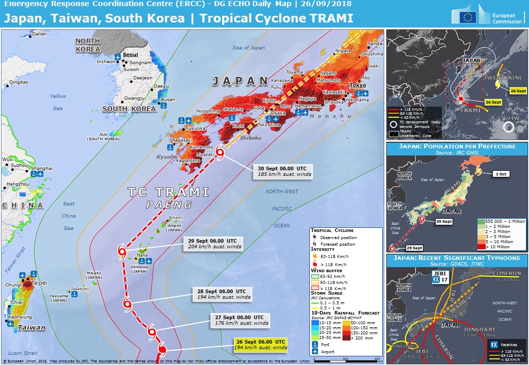
Typhoon "Trami" threatens Taiwan, Japan
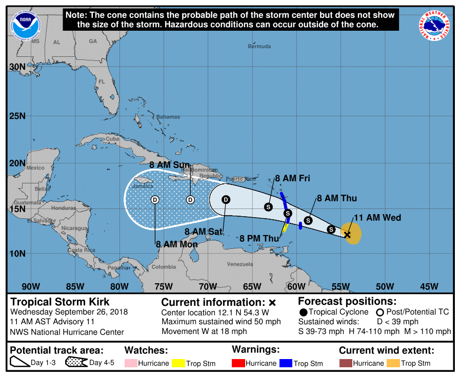
Kirk regenerates into a tropical storm, heading toward northern Windward Islands
Kirk has regenerated into a tropical storm at 09:00 UTC on Wednesday, September 26, 2018, prompting authorities to issue tropical storm warnings and watches for portions of the Lesser Antilles.
Tropical Storm Warning is in effect for Barbados, St. Lucia, Dominica, Martinique and Guadeloupe. Tropical Storm Watch is in effect for St. Vincent and the Grenadines.
On the forecast track, the center will move over the Lesser Antilles within the Tropical Storm Warning area Thursday night, September 27 (AST).
Eruption at Piton de la Fournaise continues, Reunion Island
After a slight increase in intensity of the volcanic tremor, the volcano is now in a relatively stable level despite some subtle fluctuations.
L'éruption continue au #PitondelaFournaise. Le cône poursuit son édification pendant que la zone de fontaines actives est maintenant fermée et que le lac est isolé dans une bouche sommitale unique (voir la prise de vue aérienne du site éruptif du 25 septembre). pic.twitter.com/ELPdnZsQrO
— Observatoire Volcanologique Piton de la Fournaise (@ObsFournaise) September 26, 2018
Significant eruptive activity continues at Krakatau, Indonesia
The activity of Krakatau remains important, with 440 eruptive earthquakes recorded on 25 September, and a continuous tremor of dominant amplitude at 40 mm. Ash emissions to the Southwest have clouded Verlaten Island, on Sentinel 2 imagery. The level of activity remains at 2 / Waspada, with a 2 km (1.2 miles) forbidden zone and an orange VONA.
Lava fountaining up to 100 m (330 feet) at Veniaminof, Alaska
The eruption from Veniaminof volcano's summit cone continues. Recent satellite images indicate the active lava flow has reached 0.9 km (0.56 miles) from the vent to the south. Seismicity remains elevated with continuous tremor.
Video of #Veniaminof in eruption, Sept 25, 2018, ~7:30 am AKDT. Video courtesy of Joe Timmreck. pic.twitter.com/RXSb3DLfUv
— Alaska AVO (@alaska_avo) September 26, 2018
Volcanic ash deposited on snow and ice at #Veniaminof (AK, USA) forms natural (though ephemeral) 'wind-roses' in these @planetlabs images from Sept 16 and 25. Looks like snowfall covered the earlier ash deposit.
Images Copyright 2018 Planet Labs Inc. pic.twitter.com/UulkhbbbZD
— Simon Carn (@simoncarn) September 26, 2018
Bright meteor, a piece of Comet Encke over southern Spain
A bright meteor was recorded over southern spain at 03:31 UTC on September 26, 2018.
It was produced by a fragment from Comet Encke that hit the atmosphere at about 100 000 km/h (62 000 mph). The fireball began at an altitude of around 90 km (56 miles) over the sea, and ended at a height of about 48 km (30 miles).
The fireball was recorded by the meteor observing stations operating in the framework of the SMART Project from the astronomical observatories of Calar Alto (Almería), Sierra Nevada (Granada) and Sevilla.
Bright fireball over Reunion Island
A bright fireball streaked over Reunion Island on September 25, 2018:
Roosevelt Fire destroys at least 22 homes, Wyoming
The fire has burned over 20 234 ha (50 000 acres) 9.6 km (6 miles) south of Bondurant, Wyoming, Wildfire Today reports.
After a yesterday's survey by the Sublette County Sheriff’s Office of 50 of the 153 homes in the Hoback Ranches subdivision, 22 were found to have been destroyed by the Roosevelt Fire. Property owners are being notified by the Sheriff’s Office.
New cracks appear in pavement near mysterious Oxford sinkhole
Officials report new cracks have appeared in the pavement near a large sinkhole that has taken over a Nova Scotia park, The Canadian Press reports.
The Town of Oxford said the cause of the cracks is unknown, and officials will keep a close eye on the sinkhole’s conditions as rain is forecast for later this week.
The sinkhole first appeared in mid-July, but has since grown to a size larger than 32.6 m (107 feet) by 38.7 m (127 feet), swallowing up trees and picnic benches and drawing curious onlookers to the small town of about 1 000.
I'm a dedicated researcher, journalist, and editor at The Watchers. With over 20 years of experience in the media industry, I specialize in hard science news, focusing on extreme weather, seismic and volcanic activity, space weather, and astronomy, including near-Earth objects and planetary defense strategies. You can reach me at teo /at/ watchers.news.
Commenting rules and guidelines
We value the thoughts and opinions of our readers and welcome healthy discussions on our website. In order to maintain a respectful and positive community, we ask that all commenters follow these rules.