
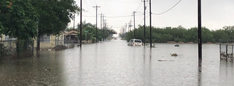
Parts of southern Texas receive record-breaking June rainfall, worst flooding since Hurricane “Harvey”
Featured image: Flooding in McAllen, TX on June 20, 2018. Credit: City of McAllen
A slow-moving low pressure area dropped record-breaking June rainfall on parts of southern Texas this week, causing the worst flooding this region has seen since Hurricane "Harvey" in August 2017. Some locations have received 127 to 381 mm (5 to 15 inches) of rain over the past 72 hours. Major flooding that followed as well as continued rainfall forced Gov. Greg Abbott to raise the State Operations Center's readiness level to from level IV (normal readiness) to level III (increased readiness) on June 19.
"Texas is no stranger to this type of severe weather, and our emergency personnel are ready and well prepared to respond," said Governor Abbott. “Our number one priority is the safety and well being of Texans, and I encourage everyone in the affected areas to stay safe and heed all warnings from local officials. I thank those involved in the response efforts, and I want to assure all Texans that we are closely monitoring the situation and will continue to provide all resources necessary.”
Areas between Weslaco and Harlingen in Rio Grande Valley received 381 mm (15 inches) of rain and suffered major flooding.
While Houston wasn't affected as much as its surrounding areas, with less than 127 mm (5 inches) since the rain began on June 17, the city broke its daily June rainfall record with 32 mm (1.26 inches) on June 17. This also made June 17th the second wettest June day in Houston's recorded history.
Port Arthur streets turned into raging rivers after the city received more than 178 mm (7 inches) of rain on June 19 alone. The Beaumont Port Arthur airport broke its daily rainfall record on the same day when 149.6 mm (5.89 inches) of rain were recorded.
NWS office in Corpus Christi said the city received 327.4 mm (12.89 inches) of rain between 07:00 local time, June 18 and 07:00 on June 20.
Resident's of the state's coastal regions were urged to seek higher ground early Wednesday, June 20, as the National Weather Service issued Flash Flood Warnings for southeast Hidalgo and northwest Cameron counties. Flash Flood Emergency was also issued for Port Aransas on the same day as several feet of water covered streets.
Port Aransas Police Chief Scott Burroughs said that just about every street in the town was flooded at some point on June 20. Floodwaters entered some homes but there were no reports of major damage, he said. Burroughs added that this town is still in the beginning stages of recovery after getting hit by Hurricane "Harvey."
Nearly every access road we have passed on Highway 83 from McAllen to Harlingen is flooding. Cars are either trying to drive through and are getting stuck, or are waiting on highways with flashers on, trying to figure out next moves. pic.twitter.com/GHybDcmpot
— Sonia Moghe (@soniamoghe) June 20, 2018
Roads just about impassible heading into #PortArthur #texas @breakingweather @accuweather pic.twitter.com/R5rvfSmah6
— Jonathan Petramala (@jpetramala) June 19, 2018
Flash flooding damages homes near Beaumont https://t.co/kqqLpyYm8g pic.twitter.com/ZzavW7O5nf
— KHOU 11 News Houston (@KHOU) June 20, 2018
South Texas is getting pounded with rain and flash floods. Flash flood warning until tomorrow. Just got a few pics from friends there. pic.twitter.com/H1vJQJqBxl
— Danny (@dahomes) June 20, 2018
McAllen Fire crews rescued a
91-year- old woman due to rising water in her home. Please be safe out there McAllen. pic.twitter.com/x22LZUvc9C— City of McAllen, TX (@CityofMcAllen) June 20, 2018
⚠️A reminder to steer clear of Ebony and 24th. There are several sinkholes in the area. #DriveSafe pic.twitter.com/Pa9ROOHqm2
— City of McAllen, TX (@CityofMcAllen) June 20, 2018
Be careful out there. Slow-going for us along Gulf Fwy inbound near Beltway 8 #khou11 pic.twitter.com/CEdMFQeJQb
— Jason Miles (@JMilesKHOU) June 20, 2018
McAllen Fire Dept. is assisting with rescues in the Mid-Valley. #BeSafe pic.twitter.com/O3L00dWNKP
— City of McAllen, TX (@CityofMcAllen) June 20, 2018
What a difference just a few hours makes in #PortArthur #Texas Highway 96 is back open and the flooding has receded as the rain has shifted to the West. @breakingweather @accuweather pic.twitter.com/BnLJl2ef0h
— Jonathan Petramala (@jpetramala) June 20, 2018
A slow moving front stretching from the Mid-Atlantic coast to the southern Plains will continue to pose a threat for thunderstorms and flash flooding over the next couple of days, but with waning coverage across the lower 48 each day, NWS said Thursday, June 21.
Conditions near and south of the frontal boundary will see high humidity with anomalously high moisture values which will support diurnally driven thunderstorms during the afternoon and evening hours. Some of these thunderstorms will have the ability to produce strong to locally severe weather in addition to heavy downpours with flash flooding.
One of two significant threats for flash flooding through Thursday morning exists in the vicinity of northwestern Iowa into portions of eastern South Dakota/Nebraska near a surface low and out head of an upper level disturbance crossing the Plains.
An equally concerning threat is in place from South Texas, up the coastal plain into the Sabine River valley.
A slow moving upper level low over South Texas will gradually begin to shift south and west over the next 12 to 36 hours, allowing for a reduction in available moisture and lift which should end the flash flood threat with Friday likely a dry day for the region as well as Saturday.
Thursday's threat for flash flooding will again be focused in the vicinity of the front, with a focus over Illinois, Indiana into eastern Kentucky, but with reduced coverage for much of the Plains.
Widespread coverage of thunderstorms will still be expected near and south of the front, however.
I'm a dedicated researcher, journalist, and editor at The Watchers. With over 20 years of experience in the media industry, I specialize in hard science news, focusing on extreme weather, seismic and volcanic activity, space weather, and astronomy, including near-Earth objects and planetary defense strategies. You can reach me at teo /at/ watchers.news.
Commenting rules and guidelines
We value the thoughts and opinions of our readers and welcome healthy discussions on our website. In order to maintain a respectful and positive community, we ask that all commenters follow these rules.