
4th nor’easter in 3 weeks to bring heavy snow, gusty winds and coastal flooding
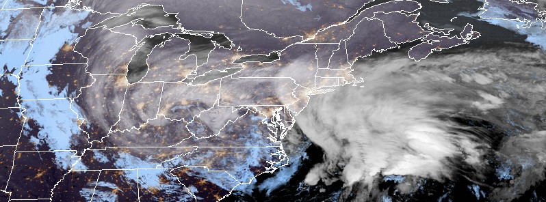
Image credit: GOES-East image acquired 08:00 UTC, March 21, 2018
The 4th nor'easter in 3 weeks will bring another round of heavy snow, gusty winds, and coastal flooding to the east coast US today and tomorrow. The last time 4 nor'easters marched through the region within 3 to 4 weeks weeks was in 2015 and before that in 1986/87.
Another coastal low/nor'easter is underway as the surface low located in the Carolinas will move into the Atlantic by tonight, NWS forecaster Reinhart notes. Meanwhile, a swath of precipitation will move across the Ohio Valley into the Appalachians, Mid-Atlantic, and Northeast.
For today, the rain/snow line will stretch from New Jersey southward into the Washington DC metro area through southern Virginia. North of that line, areas will experience mostly snow especially throughout the Ohio Valley and central Appalachians.
Along the rain/snow line, mixed precipitation in the form of rain, sleet, and snow will occur while rain and thunderstorms will be possible across the Carolinas and southern Virginia.
As the low moves along the coast tonight, the rain/snow line will shift to the east, with snow spreading across most of the Mid-Atlantic and coastal areas of the Northeast and New England.
Snow will continue across these regions through Wednesday as the low tracks northward along the East Coast. However, parts of coastal New England can expect precipitation to change over to rain by Wednesday afternoon, March 21.
On Thursday, March 22, most of the precipitation will be in the form of snow in the New England region as the low treks northward towards the Canadian Maritimes. Snow may linger by Thursday evening in the interior of New England but the significant snowfall will come to an end at that point.
The last time 4 nor'easters marched through the region within ~3 to 4 weeks was in 2015. The fourth, on February 14 and 15, pushed Boston into its snowiest winter season on record, with 280.9 cm (110.6 inches) from November 2014 to March 2015.
The previous occurrence took place in late 1986 and early 1987.
A known occurrence of four nor'easters in four weeks for the northeastern United States pic.twitter.com/xwfVwTP6zw
— NWS WPC (@NWSWPC) March 20, 2018
I'm a dedicated researcher, journalist, and editor at The Watchers. With over 20 years of experience in the media industry, I specialize in hard science news, focusing on extreme weather, seismic and volcanic activity, space weather, and astronomy, including near-Earth objects and planetary defense strategies. You can reach me at teo /at/ watchers.news.
Commenting rules and guidelines
We value the thoughts and opinions of our readers and welcome healthy discussions on our website. In order to maintain a respectful and positive community, we ask that all commenters follow these rules.