
New crevasses near Suswa shield volcano raise concerns, Great Rift Valley, Kenya
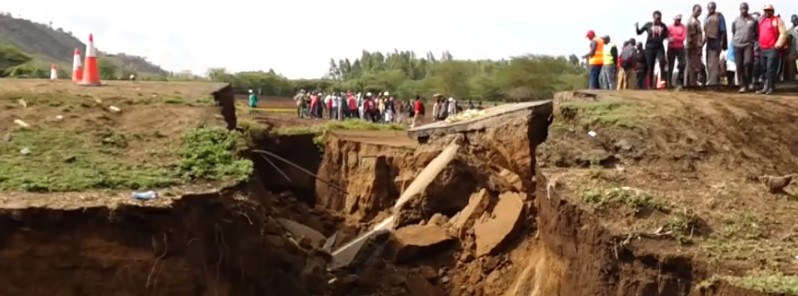
Image credit: Kenya News Alert
New crevasses appeared in Suswa shield volcano area, Kenya on March 19, 2018, severely damaging busy Mai Mahiu-Narok road just one week after a similar incident occurred on the same road.
The tear is as much as 15 meters (50 feet) deep and more than 20 meters (65 feet) wide, geologists said, adding that this spot is just one of the tens, perhaps hundreds, of other weak spots on the Great Rift Valley, which runs through the continent from the Horn of Africa to Mozambique.
Suswa, located between Narok and Nairobi counties, is a shield volcano that lies on the Great Rift Valley which has a history of tectonic and volcanic activity.
"Whereas the rift has remained tectonically inactive in the recent past, there could be movements deep within the Earth’s crust that have resulted in zones of weakness extending all the way to the surface," geologist David Adede said.
Because of the problem deep within the Earth’s crust at Suswa, Mr. Adede says, ongoing repair works by Kenya National Highways Authority, including filling the cracks with concrete and rocks, will only provide a temporary solution.
"You cannot stop a geological process because it occurs from deep within the crust of the Earth," he says.
Some families living in the area near the fissure started moving out on Monday, including a 72-year-old Mary Wambui who told reporters that 'staying here is like courting death.'
She was having dinner with the rest of the family on Monday when the Earth suddenly cracked beneath their feet, cutting their home into two.
Geological summary
The southernmost caldera of the Kenya rift, Suswa contains a prominent lava cone on the south side of its 8 x 12 km (5 x 7.4 miles) caldera. Suswa lies south of Longonot volcano and about 50 km (31 miles) WNW of the capital city of Nairobi. Construction of an early shield volcano was followed by eruption of voluminous Pleistocene pumice and lava flows that accompanied the incremental formation of the caldera.
The 2 356-m (7 729 feet) summit of the phonolitic-to-trachytic volcano is formed by the post-caldera lava cone of Ol Doinyo Onyoke ("The Red Mountain," also known as Ol Doinyo Nyukie) on the south side of the caldera. Its large elongated summit crater is truncated on the north by a ring graben.
This unusual 5-km-wide (3.1 miles) circular graben at the center of the older caldera isolates a tilted island block of caldera-floor lava flows. The latest eruptions have originated from satellitic vents that issued lava flows which remain unvegetated and may be only a century or so old. (GVP)
Commenting rules and guidelines
We value the thoughts and opinions of our readers and welcome healthy discussions on our website. In order to maintain a respectful and positive community, we ask that all commenters follow these rules.