
Earthquake swarm under Mount Ruapehu, New Zealand
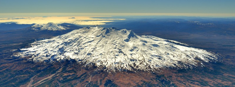
Featured image: Aerial View of Mount Ruapehu from the South West. Credit: D. Townsend
An episode of volcanic earthquakes is occurring beneath Mount Ruapehu since March 15, 2018. This is a common observation during a heating phase of the crater lake (Te Wai ā-moe), GeoNet scientist Brad Scott reports. Crater lake's current temperature of 39 °C (102.2 °F) is above the 95th percentile of the long-term distribution of measured temperatures at the lake.
GNS Science volcanologists have detected an ongoing sequence of seismic events beneath Mount Ruapehu that can be categorized as volcanic earthquakes.
The quakes have relatively small magnitudes and cannot be located by GeoNet’s automatic earthquake detection system but the pattern of seismic recordings indicates a source beneath the summit area, the agency said.
The distinction between volcanic earthquakes and volcanic tremor is gradational and a sequence of discrete volcanic earthquakes can evolve into a more continuous seismic signal which would then be called volcanic tremor.
The crater lake (Te Wai ā-moe) temperature is currently at 39 °C (102.2 °F), which is above the 95th percentile of the long-term distribution of measured temperatures at the lake (i.e. only 5% of temperature measurements made since 2009 are equal or greater than 39 °C).
The lake has been at an elevated temperature since August 2017 (see also RUA -2017/01).
It is not unusual to observe volcanic earthquakes during phases of increased heat input into the lake, Scott said, adding that similar episodes were observed during April 2016 and September 2017 but did not result in an increase in volcanic unrest.
The Volcanic Alert Level, therefore, remains at 1 and the Aviation Colour Code at Green.
Geological summary
Ruapehu, one of New Zealand's most active volcanoes, is a complex stratovolcano constructed during at least four cone-building episodes dating back to about 200 000 years ago.
The 110 km3 (26.4 mi3) dominantly andesitic volcanic massif is elongated in a NNE-SSW direction and surrounded by another 100 km3 (24 mi3) ring plain of volcaniclastic debris, including the Murimoto debris-avalanche deposit on the NW flank.
A series of subplinian eruptions took place between about 22 600 and 10 000 years ago, but pyroclastic flows have been infrequent. A single historically active vent, Crater Lake, is located in the broad summit region, but at least five other vents on the summit and flank have been active during the Holocene.
Frequent mild-to-moderate explosive eruptions have occurred in historical time from the Crater Lake vent, and tephra characteristics suggest that the crater lake may have formed as early as 3 000 years ago. Lahars produced by phreatic eruptions from the summit crater lake are a hazard to a ski area on the upper flanks and to lower river valleys. (GVP)
I'm a dedicated researcher, journalist, and editor at The Watchers. With over 20 years of experience in the media industry, I specialize in hard science news, focusing on extreme weather, seismic and volcanic activity, space weather, and astronomy, including near-Earth objects and planetary defense strategies. You can reach me at teo /at/ watchers.news.
I love news about world
<3 love to have you here