
Tropical Cyclone 03S forms off the coast of Western Australia
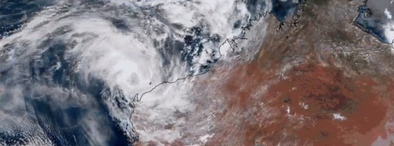
Featured image: Tropical Cyclone 03S (Three) on January 28, 2017. Credit: JMA/Himawari
Tropical Cyclone 03S formed off the coast of Western Australia on January 27, 2017. It is only the third tropical cyclone to form in the 2016/17 southern hemisphere season. This is the fewest on record between January 1 and 27, according to Philip Klotzbach of the CSU.
This system first formed on January 23 in the western area of the Gulf of Carpentaria. After moving west-southwestward over land, the low gradually developed and was designated by the BOM as 14U on January 26. The JTWC began issuing advisories on January 27, classifying it as 03S as it moved over water.
TC 03S is moving further away from the coast. It might intensify over the next 24 hours but should not affect the mainland.
At 15:00 UTC on January 28, it was located approximately 250 km (216 miles) northwest of Learmonth, Australia and has tracked westward at 26 km/h (16 mph) over the past six hours, according to the JTWC.
Animated enhanced infrared multispectral satellite imagery depicts rapidly decaying deep convection over a broad low-level circulation center.
The initial intensity is assessed at 74 km/h (46 mph) based on an average of Dvorak current intensity estimates ranging from 64 km/h (40 mph) to 83 km/h (52 mph).
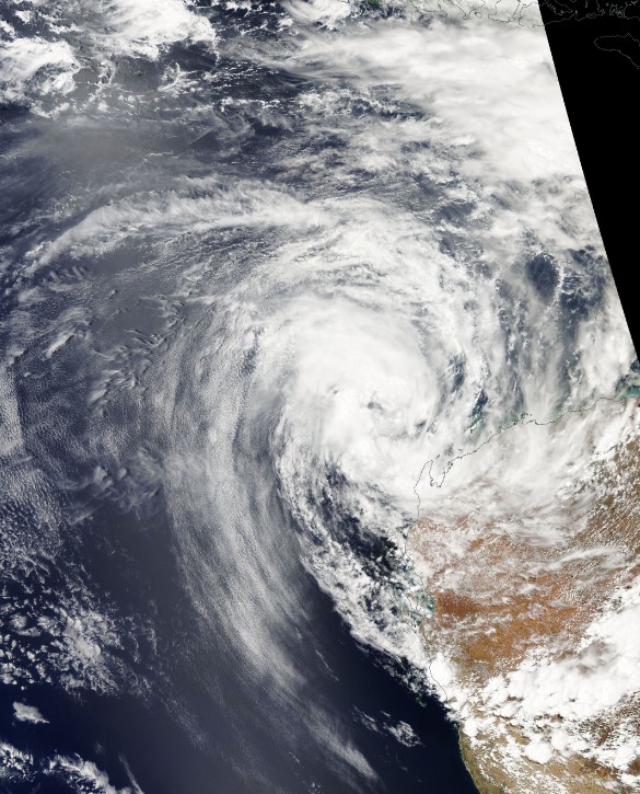
Tropical Cyclone 03S on January 28, 2017. Credit: NASA Aqua/MODIS
TC 03S is forecast to track westward to west-southwestward along the northern periphery of the low- to mid-level subtropical ridge over the next 48 hours.
Environmental conditions remain marginally conducive for a brief period of intensification within the next day, however, conditions will thereafter become unfavorable due to decreasing sea surface temperature and entrainment of cooler, more stable air.
Maximum significant wave height at 12:00 UTC today was 4.3 m (14 feet).
Tropical Cyclone 03S churning northwest of Australia — via #Himawari GeoColor pic.twitter.com/KsrNN356y8
— NWS OPC (@NWSOPC) January 28, 2017
At 13:19 UTC today, BOM said that the intensity analysis of 74 km/h (46 mph) is influenced by surface observations from earlier in the day coupled with the continued quick translation speed. However, as gales are likely on the southern side only, the system is not rated at tropical cyclone intensity.
In Australia, this system is known as Tropical Low 14U.
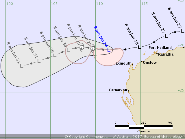
Tropical Cyclone 03S (Tropical Low 14U) – Forecast track by BOM on January 28, 2017
The potential for the system to intensify is contingent on whether overnight convection re-develops. Forecast policy is somewhat conservatively continuing to indicate that gales may extend to northern quadrants for a brief period from Sunday morning [T+12h], BOM said.
"However, this is becoming less likely now in line with the latest model guidance, despite strong model consensus that the system will slow down on Sunday. In any case, gales are likely to continue southwest of the center for a period as the translation speed combines with the synoptic southeasterly flow."
The Watchers team and our contributors bring the latest on extreme weather, earthquakes, volcanic eruptions, space weather, and all things science. We're all about making sense of the natural world and keeping you informed on what’s happening. Got a tip or a question? Hit us up using the form at newstips!
Commenting rules and guidelines
We value the thoughts and opinions of our readers and welcome healthy discussions on our website. In order to maintain a respectful and positive community, we ask that all commenters follow these rules.