
NASA’s El Niño new animation study compares the 1997/98 and 2015/16 phenomenon
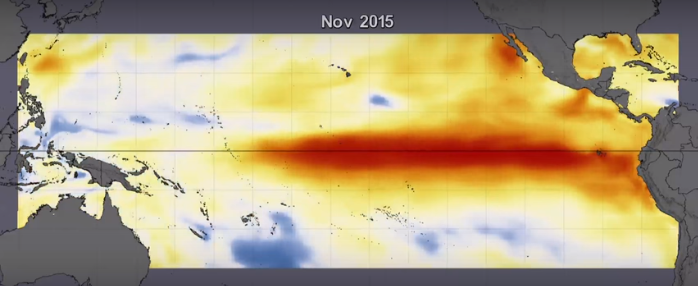
Featured image: El Niño phenomenon, November 2015. Image credit: NASA
NASA's scientists produced a new animation showing the 2015 El Niño event unfolding the Pacific Ocean. Observed changes in the sea surface temperature (SST) vary greatly from those typical for the 1997/98 phenomenon; they are stronger and deeper. The La Niña forecast still remains fairly uncertain.
During El Niño, variations of the water temperature occur not only at the surface of equatorial Pacific but also below the surface. This season, sea surface temperatures have produced different patterns when compared with 1997/98 event. During the El Niño maximum in November 2015, colder than average temperatures were reported in the Western Pacific while warmer than average conditions took place in the Eastern Pacific. Also, the changes in temperature were stronger and extended deeper than during 1997.

Visualization showing sea surface temperature (SST) anomaly data from January 1, 2015, through February 14, 2016. Video credit: NASA

Visualization showing sea surface temperature (SST) anomaly data from January 1, 1997, through February 14, 1998. Video credit: NASA
The 1997 event started with colder than average SSTs while the current phenomenon started with warmer than average temperatures in the Pacific, Atlantic and Indian Oceans.
"The '97 El Niño was much stronger in the Eastern Pacific, with much warmer water up to the coast of South America," said Robin Kovach, a research scientist with the Global Modeling and Assimilation Office (GMAO). Unlike that, the Central Pacific and a region west of the International Date Line have seen the warmest waters in 2015.
NASA's computer models utilized the input data from ocean buoys, atmospheric models, satellite data and numerous other sources to simulate the behavior of the ocean temperatures over the coming months. The GMAO seasonal forecast model suggests the current phenomena will retain its different characteristics until the end. Models run in February 2016 predict the SSTs will return to normal by June.

Visualization showing sea surface temperature (SST) anomaly data and subsurface temperature anomaly data from January 1, 2015, through February 14, 2016. Video credit: NASA

Visualization showing sea surface temperature (SST) anomaly data and subsurface temperature anomaly data from January 1, 1997, through February 14, 1998. Video credit: NASA
The February 5 run of the model doesn't predict the colder-than-average temperatures, necessary to produce a large La Niña. As of February 14, the computer simulation indicates colder-than-average conditions off the South American coast, extending from Ecuador to Panama.
In the past, very strong El Niño events typically transition to neutral conditions and then a La Niña event. This current El Niño has been different so it will be interesting to see what happens in the next forecast and the coming months.

Earlier reporting
Nothing on Watchers was published in the last 24 hours. These are older articles.
- On October 22, 2017, a single flash of lightning stretched 515 miles from eastern Texas to near Kansas City, a distance that takes eight hours to drive, and nobody realized how far it had gone until scientists went back through the satellite data years later Epicenter
- CPC posts a slight risk of heavy rain from the Gulf Coast to the Northeast urban corridor November 25-29, and a moderate risk of West Coast wind and Sierra snow on November 25
- Florida's east coast faces a moderate flash flood risk Wednesday through Friday, with 4 to 8 inches of rain forecast and the St. Johns River near Cocoa already in major flood at 17.13 feet
- Cyclone Akvan to make landfall between Nellore and Visakhapatnam around noon on November 20, IMD forecasts 120-130 km/h winds gusting to 145

So cavalier, perhaps you don’t consider the suffering and dying caused to all trying to live on Earth. Am glad you can hardly wait to see what is forthcoming for us to endure. I am not. From boiling hot temperatures to colder than normal. Have a little humility, ok? Since there has been a deathhold on climate change information from the media, you could at least shine a little hope on this situation. You may be a denier, I think.