
2015 maximum sea ice cover lowest recorded since 2008
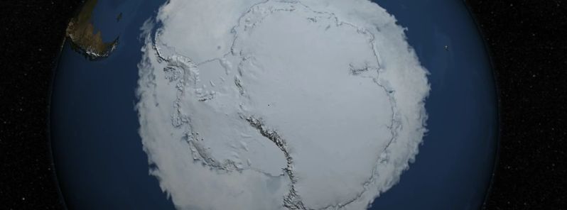
Featured image: Antarctic sea ice reaching its annual maximum extent on October 6, 2015. Image credit: NASA's Goddard Space Flight Center
The sea ice cover of the Southern Ocean reached its yearly maximum extent on October 6, 2015. Sea ice cover at its maximum has spread across the area of 18.83 million square kilometers (7.27 million square miles), which puts it both on the 22nd lowest and 16th highest maximum extent ever recorded. This is roughly in the middle of the record of Antarctic maximum extents compiled over the last 37 years.
This year’s maximum sea ice extent occurred later than usual, as the mean date of the Antarctic maximum was September 23, in the climatological period between 1981 and 2010, NASA reported on October 15. The 2015 Antarctic maximum sea ice extent is also the lowest recorded since 2008, which is quite a bit smaller than over the three previous years.
Antarctic sea ice cover has been growing irregularly this year – it was much higher than usual for most of the first half of the year, flattened out in mid-July and then fell below normal levels during mid-August.
Antarctic sea ice likely reached its annual maximum extent on October 6, 2015 barring a late season surge. This video shows the evolution of the sea ice cover of the Southern Ocean from its minimum yearly extent to its peak extent. Image credit: NASA's Goddard Space Flight Center
By September, the cover has somewhat recovered, although it's still 1.33 million square kilometers (513 515 square miles) below the record maximum extent of 2014.
This year's behavior of sea ice cover is most likely influenced by the strong El Niño weather phenomena, responsible for warming up the surface waters of the eastern equatorial Pacific Ocean.
El Niño causes higher sea level pressure, warmer air temperature and warmer sea surface temperature in the Amundsen, Bellingshausen and Weddell seas in west Antarctica that affect the sea ice distribution.
“After three record high extent years, this year marks a return toward normalcy for Antarctic sea ice. There may be more high years in the future because of the large year-to-year variation in Antarctic extent, but such extremes are not near as substantial as in the Arctic, where the declining trend towards a new normal is continuing,” said Walt Meier, a sea ice scientist at NASA’s Goddard Space Flight Center in Greenbelt, Maryland.
Antarctic sea ice again surges upward !
“LOL, how about a little ‘whoops?! from NASA,” says reader Andrew Stranglen.
“Just as they declare maximum ice extent reached on October 6th, …Antarctic Sea Ice again surges upward, just a couple of days ago.”
“Thesy (NSIDC) are only showing the image for 10/15 which does not show the upward spike, and apparently there is no link to see yesterday’s image 10/14 which I think is the one with the spike.
“So much for NSIDC ‘transparency’!