
NASA: Global temperatures and Arctic sea ice extent continue setting new records
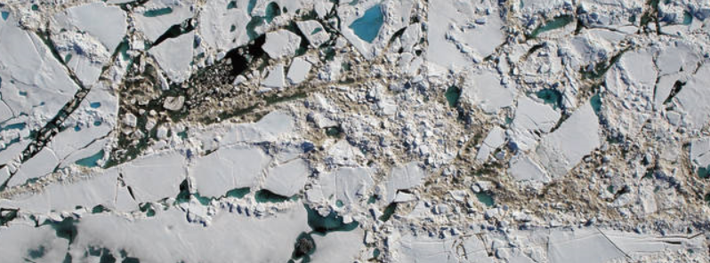
Featured image: Chunks of sea ice, melt ponds and open water are all seen in this image captured at an altitude of 457 m (1 500 feet) by the NASA's Digital Mapping System instrument during an Operation IceBridge flight over the Chukchi Sea on Saturday, July 16, 2016. Image credit: NASA/Goddard/Operation IceBridge
Analysis of climate conditions, conducted by NASA's scientists shows the global surface temperatures and Arctic sea ice extent during the first half of 2016 set new records and are continuing trends of change observed over the last few decades.
NASA's Goddard Institute for Space Studies (GISS) New York researchers have confirmed that the period between January and June 2016 was the warmest six months period recorded so far, as an averaged temperature was 1.3°C (2.4°F) higher than the previous record, reported in 1880.
Also, five months of the year have set a new record for the lowest respective monthly Arctic sea ice extent since 1979 with the only exception being March, which reported the second smallest extent for the month.
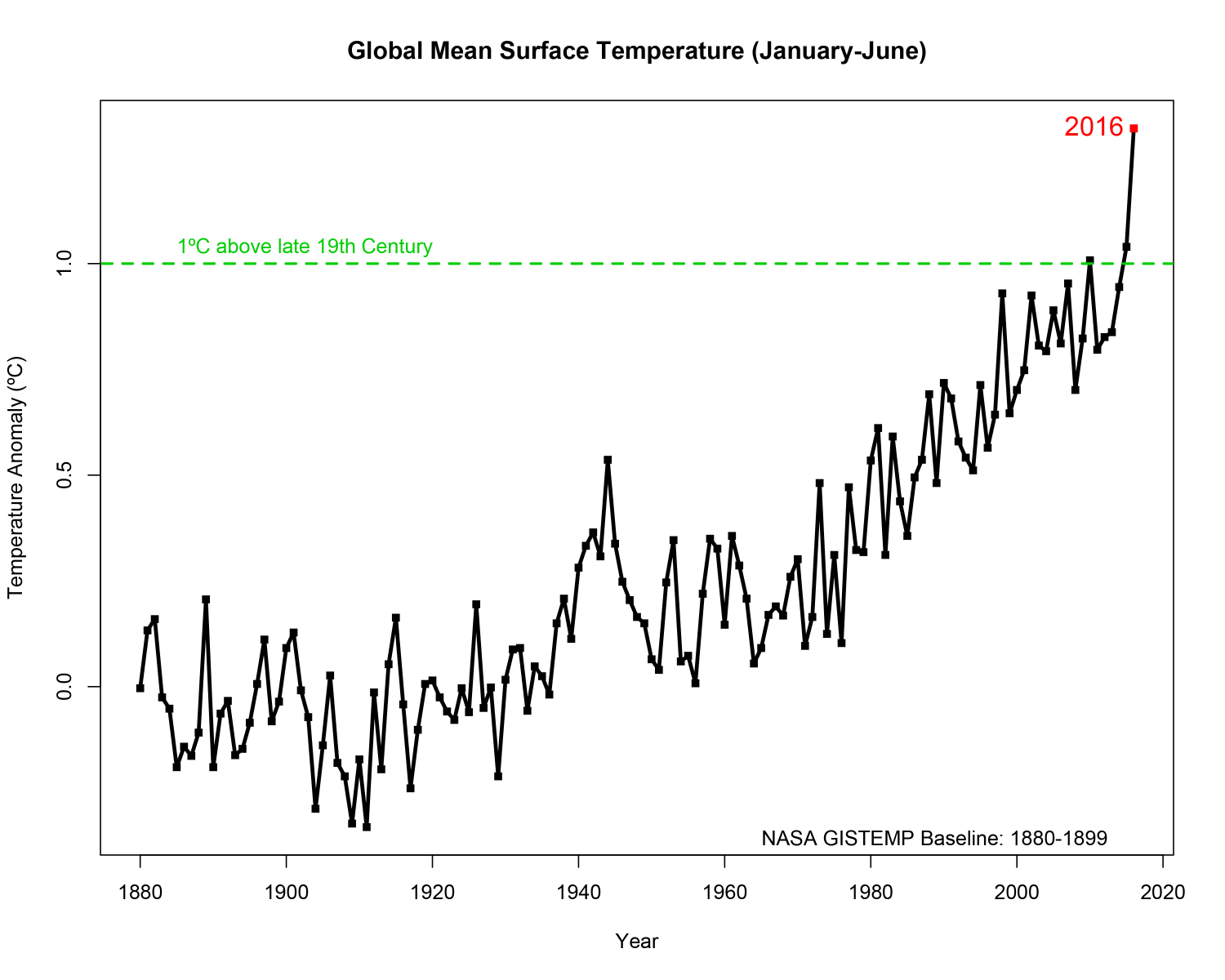
The first six months of 2016 were the warmest six-month period in NASA's modern temperature record, which dates to 1880. Image credit: NASA/Goddard Institute for Space Studies
However, the scientists emphasize that it is even more important that trends observed in the global temperature and sea ice extent continue decades-long trends of change, driven by increasing concentrations of heat-trapping carbon dioxide and other greenhouse gasses.
A typical amount of the sea ice cover at the peak of the summer melt season is currently at 40% less than during the late 1970s and early 1980s while in September, the seasonal minimum is declining at a rate of 13.4% per decade.
"While the El Niño event in the tropical Pacific this winter gave a boost to global temperatures from October onwards, it is the underlying trend which is producing these record numbers," GISS Director Gavin Schmidt said.
This year, even with El Niño season ending, the global temperatures have risen to the highest levels, and the global trend is outpaced by the regional Arctic warming.
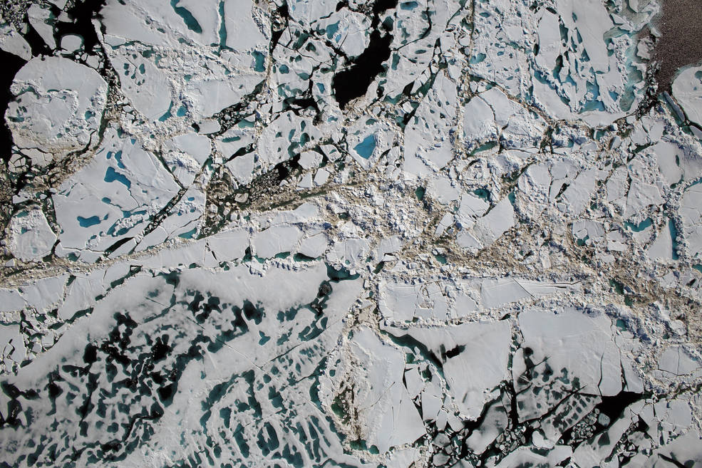
Chunks of sea ice, melt ponds and open water are all seen in this image captured at an altitude of 457 m (1 500 feet) by the NASA's Digital Mapping System instrument during an Operation IceBridge flight over the Chukchi Sea on Saturday, July 16, 2016. Image credit: NASA/Goddard/Operation IceBridge
"It has been a record year so far for global temperatures, but the record high temperatures in the Arctic over the past six months have been even more extreme. This warmth, as well as unusual weather patterns, have led to the record low sea ice extents so far this year," said Walt Meier, a sea ice scientist at NASA Goddard.
NASA maintains 19 Earth-observing space missions and sends its researchers across the world to investigate our planet and how it's changing. The Operation IceBridge campaign has started with a series of airborne measurements of shallow pools of water, that form during the ice melting, the so-called melt ponds in the Arctic. Most recent research indicates the formation of melt ponds during the early summer may be a good indicator of the yearly minimum sea ice extent in September.
Video credit: NASA Goddard
"No one has ever, from a remote sensing standpoint, mapped the large-scale depth of melt ponds on sea ice. The information we’ll collect is going to show how much water is retained in melt ponds and what kind of topography is needed on the sea ice to constrain them, which will help improve melt pond models," said Nathan Kurtz, IceBridge’s project scientist and a sea ice researcher at NASA Goddard.
This year, the NASA's scientists have also begun an almost decade-long, multifaceted field study of Arctic ecosystems based in Alaska and Canada. The Arctic-Boreal Vulnerability Experiment (ABoVE) is planned to explore how forests, permafrost, and other ecosystems respond to increasing temperatures in the Arctic, where climate change is unfolding faster than anywhere else on the planet.
Yup snow on six of seven continents in July the ice caps melting what a crock. Hottest years on record what a bigger crock. How long will the sheeple listen to the globalist lies?
https://www.youtube.com/watch?v=I_-OxwNEFj4