
Tropical Storm “Arthur” could become first hurricane of 2014 Atlantic hurricane season
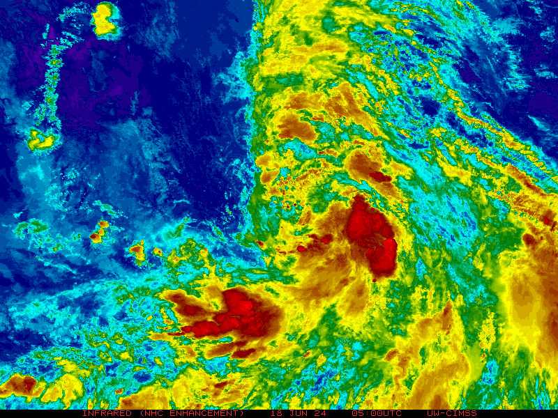
Featured image: GOES East IR satellite image of TS Arthur taken at 06:45 UTC on July 2, 2014 (Credit: NOAA/UW-CIMSS)
The first tropical depression of the Atlantic hurricane season strengthened into Tropical Storm "Arthur" today. This tropical storm formed east of Florida early on July 2, 2014, with further strengthening likely as the system is forecasted to turn northward this week alongside the East coast.
Arthur has a good chance of becoming Atlantic season's first hurricane.
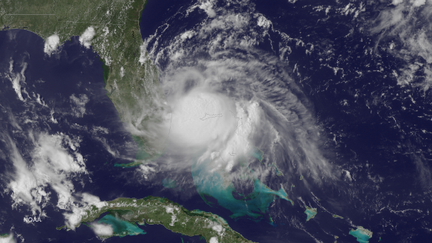
GOES East satellite image of Tropical Storm Arthur at 19:45 UTC on July 1, 2014. (Credit: NOAA/GOES East)
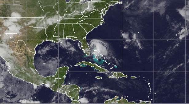
Low-pressure area developed over South Carolina on June 29, 2014, and moved east into the Atlantic Ocean where the warm waters of the Gulf Stream helped fuel it. On July 1st that area of low pressure developed into Tropical Depression One. The National Hurricane Center issued a Tropical Storm Watch for the east coast of Florida from Fort Pierce to Flagler Beach.
According to the latest public advisory by NHC, the center of TS Arthur is located about 95 miles (155 km) ESE of Cape Canaveral, Florida and about 105 miles (170 km) N of Freeport, Grand Bahama Island and is moving northward at speed of 4 mph (6 km/h). Maximum sustained winds are 60 mph (95 km/h) and minimum central pressure is 1001 mb (29.56 inches). Tropical-storm-force winds extend outward up to 70 miles (110 km) from the center.
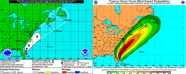
5-day forecast track and tropical storm force wind speed probabilities (Credit: NOAA/NHC)
The center of Arthur is expected to remain just offshore and move east of the east-central coast of Florida, pass east of northeastern Florida and move parallel to the southeastern coast of the United States. Strengthening is forecast during the next 48 hours and Arthur is expected to become a hurricane later on July 3, 2014.
.png)
The surf and strong rip current risk builds as Arthur strengthens and tracks northward. Heavy rain, gusty thunderstorms and coastal flooding are possible. The greatest impact is expected from eastern North Carolina to Long island and Cape Cod, Massachusetts.
A tropical storm watch is in effect for East Coast of Florida from Fort Pierce to Flagler Beach. A tropical storm watch means that tropical storm conditions are possible within the watch area… in this case within the next 24 hours. Interests along the United States East Coast north of the watch area through southeastern Virginia should monitor the progress of Tropical Storm Arthur.
.jpg)
The TRMM satellite had a good daylight look at tropical storm Arthur on July 1, 2014 at 1620 UTC (12:20 PM EDT) less than two hours after it was upgraded from a tropical depression. (Credit: NASA/TRMM)
Arthur is expected to produce total rainfall accumulations of 1 to 2 inches, mainly across the eastern Florida Peninsula. Rainfall amounts of 2 to 4 inches with isolated maximum amounts of 6 inches are possible over the northwestern Bahamas.
Satellite Animations
- Storm-Centered Infrared (GOES 13; NOAA/SSD)
- Storm-Centered Infrared (Aviation Color Enhancement) (GOES 13; NOAA/SSD)
- Storm-Centered Water Vapor (GOES 13; NOAA/SSD)
- Storm-Centered Visible (GOES 13; NOAA/SSD)
- Storm-Centered Visible (Colorized) (GOES 13; NOAA/SSD)
- Storm-Centered Infrared (GOES 13; CIMSS)
- Storm-Centered Enhanced Infrared (GOES 13; CIMSS)
- Storm-Centered Water Vapor (GOES 13; CIMSS)
- Storm-Centered Visible (GOES 13; CIMSS)
- Tropical Atlantic Hurricane Sector Infrared (GOES 13; NOAA)
- Tropical Atlantic Hurricane Sector Water Vapor (GOES 13; NOAA)
- Tropical Atlantic Hurricane Sector Visible (GOES 13; NOAA)
Radar
- Miami – Long Range (NOAA)
Commenting rules and guidelines
We value the thoughts and opinions of our readers and welcome healthy discussions on our website. In order to maintain a respectful and positive community, we ask that all commenters follow these rules.