
Third X-class solar flare in last 24 hours – Impulsive X1.0 from AR 2087
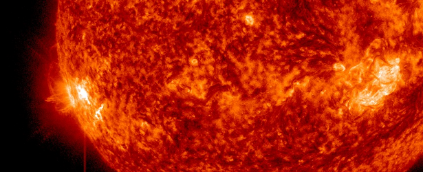
Image credit: TW
It seems like the second peak of solar maximum is here. At 09:06 UTC on June 11, 2014, Active Region 2087 located near the southeastern limb erupted with third major solar flare in last 24 hours. This latest event was impulsive X1.0 flare. It started at 08:59, peaked at 09:06 and ended at 09:10 UTC.
X1.0 flare was preceded by moderately strong M3.0 from the same region and M1.8 from AR 2080.
Impulsive solar flares do not usually release strong CMEs but since we had several partially Earth directed plasma clouds (CMEs) in last couple of days this will probably add up to geomagnetic storming expected to begin on June 13, 2014.

Space Weather Message Code: SUMX01
Serial Number: 102
Issue Time: 2014 Jun 11 0919 UTC
SUMMARY: X-ray Event exceeded X1
Begin Time: 2014 Jun 11 0859 UTC
Maximum Time: 2014 Jun 11 0906 UTC
End Time: 2014 Jun 11 0910 UTC
X-ray Class: X1.0
Optical Class: 2b
Location: S14E68
NOAA Scale: R3 – Strong
Potential Impacts: Area of impact consists of large portions of the sunlit side of Earth, strongest at the sub-solar point.
Radio – Wide area blackout of HF (high frequency) radio communication for about an hour.
Related:
- Major solar flare reaching X2.2 erupted from southeastern limb – June 10, 2014
- Second major solar flare of the day – X1.5 from southeastern limb – June 10, 2014
- Increased solar activity – After two major solar flares an impulsive M3.0 erupts from AR 2087, M1.8 from AR 2080 – June 11, 2014

Teo Blašković founded The Watchers in 2011 and edited it until 2026, covering seismic and volcanic activity, extreme weather, space weather and near-Earth objects. Articles on this page are his archive.
Published in the last 24 hours
- High Risk of excessive rainfall covers Florida’s Space Coast as St. Johns River near Cocoa reaches 5.67 m
- Four small asteroids will pass close to Earth from November 21 to 23
- Cyclone Akvan weakens after landfall near Gopalpur; more than 300 000 evacuated in Odisha, India
- A broad low over southeastern Florida and the northwestern Bahamas has a 30 percent chance of subtropical or tropical development within 48 hours and a 50 percent chance within 7 days, the National Hurricane Center says
