
Supertyphoon Lekima and Typhoon Francisco approaching Japan
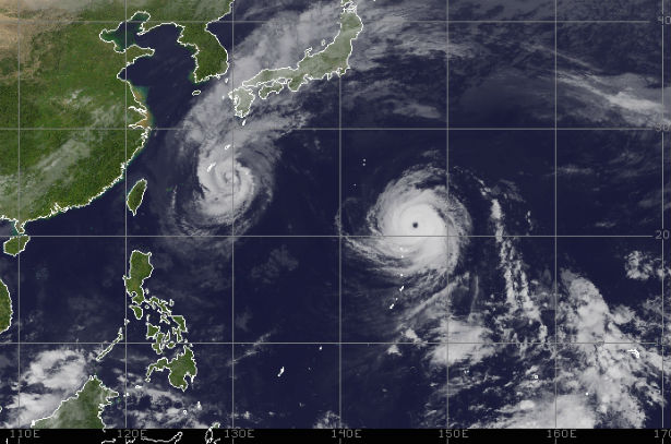
Featured image: Northwestern Pacific tropical disturbances at 04:30 UTC on October 24, 2013 (Credit: NOAA/UW/CIMSS)
Typhoon Francisco is battering Minamidaito Island in Okinawa Prefecture, Japan. The system is forecast to make a sharp northeastward turn over the next few days and skirt the eastern seaboard of mainland Japan. Francisco has maximum sustained winds of 65 knots (120 km/h, 75 mph) with gusts up to 80 knots (148 km/h, 91 mph).
Super Typhoon Lekima is on a northwest path toward Iwo Jima and it is forecasted to turn away to the northeast in the next 48 hours. Maximum sustained winds are 140 knots (260 km/h, 162 mph) with gusts up to 170 knots (314 km/h, 195 mph)
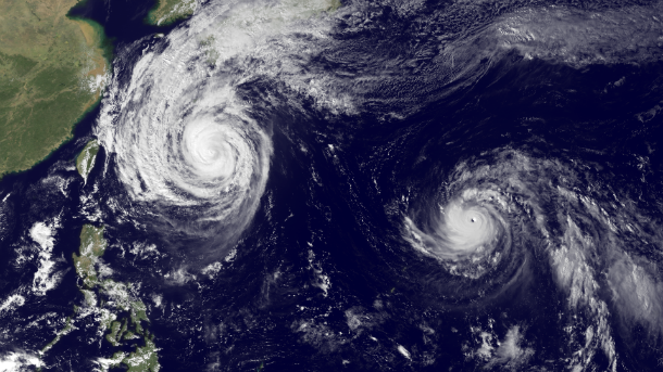
MTSAT-1 satellite image of two tropical systems taken at 04:30 UTC on October 23, 2013. (Credit: NOAA/MTSAT)
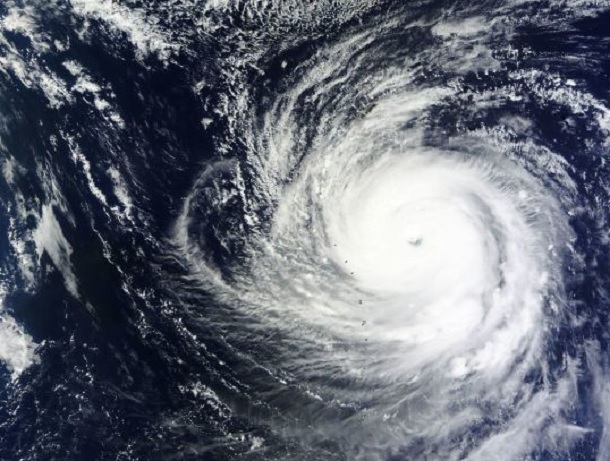
Typhoon Francisco
According to latest report by Joint Typhoon Warning Center (JTWC), the center of Typhoon Francisco was located approximately 129 nm southeast of Kadena AB. The system is moving north-northwestward at speed of only 2 knots over the past six hours. Although Francisco has been following a track similar to deadly Typhoon Wipha from last week, it is expected to curve to the northeast before reaching much of Japan.
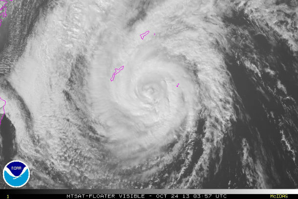
MTSAT visible satellite image of Typhoon Francisco taken at 03:57 UTC on October 24, 2013 (Credit: NOAA/SWPC)
Sustained winds are expected to gust up to 30 mph, with isolated gusts to 40 mph on the coastal areas of eastern Kyushu, southern Shikoku and southern Honshu. Heavy rain is still expected to impact the country through the first half of the weekend.
Cooler waters and front pushing through eastern China will steer Francisco eastward and influence its weakening trend. Extra- tropical transition and interaction with the baroclinic zone will begin after the next two days, with complete transition to a cold-core system expected by the next 72 hours.
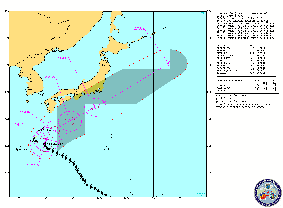
Typhoon Francisco forecast track (Credit: JTWC)
Satellite Animations
- Storm-Centered Infrared (MTSAT; NOAA/SSD)
- Storm-Centered Infrared (Aviation Color Enhancement) (MTSAT; NOAA/SSD)
- Storm-Centered Water Vapor (MTSAT; NOAA/SSD)
- Storm-Centered Visible (MTSAT; NOAA/SSD)
- Storm-Centered Visible (Colorized) (MTSAT; NOAA/SSD)
- Tropical West Pacific Infrared (MTSAT2; NOAA)
- Tropical West Pacific Enhanced Infrared (MTSAT2; NOAA)
- Tropical West Pacific Water Vapor (MTSAT2; NOAA)
- Tropical West Pacific Visible (MTSAT2; NOAA)
Supertyphoon Lekima
Supertyphoon Lekima was estimated to have a central pressure of 905 mb, which makes it the strongest typhoon of the 2013 Pacific season. According to latest report by Joint Typhoon Warning Center (JTWC), the center of Supertyphoon Lekima was located approximately 434 nm southeast of Iwo To. The system is moving west-northwestward at speed of 12 knots (22 km/h, 13 mph) over the past six hours. Maximum sustained winds are 140 knots (260 km/h, 162 mph) with gusts up to 170 knots (314 km/h, 195 mph). Maximum significant wave height is 15 meters (48 feet).
Terra MODIS satellite image of Supertyphoon Lekima taken at 01:05 UTC on October 24, 2013 (Credit: LANCE Rapid Response/MODIS)
Lekima is is currently tracking to the west-northwest along the southern periphery of the deep-layered subtropical ridge north of the system. Decreasing ocean parameters and increasing vertical wind shear will start a slow weakening process in the next 12 hours. After the next three days, the system will continue to the northeast as it begins extra-tropical transition. Further decreasing environmental factors will continue to erode the system as it quickly moves northeastward.
.gif)
Supertyphoon Lekima forecast track (Credit: JTWC)
Satellite Animations
- Storm-Centered Infrared (MTSAT2; NOAA/SSD)
- Storm-Centered Infrared (Aviation Color Enhancement) (MTSAT2; NOAA/SSD)
- Storm-Centered Water Vapor (MTSAT2; NOAA/SSD)
- Storm-Centered Visible (MTSAT2; NOAA/SSD)
- Storm-Centered Visible (Colorized) (MTSAT2; NOAA/SSD)
- Tropical West Pacific Infrared (MTSAT2; NOAA)
- Tropical West Pacific Enhanced Infrared (MTSAT2; NOAA)
- Tropical West Pacific Water Vapor (MTSAT2; NOAA)
- Tropical West Pacific Visible (MTSAT2; NOAA)
.jpg)
Historic weather patterns are just another harbinger of the soon return of Christ to this Earth.