
Antarctic ozone hole reaches maximum size for 2013
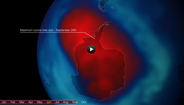
Featured image: Ozone hole on September 26, 2013 (Credit: NOAA/TOAST)
Each year for the past few decades during the Southern Hemisphere spring, chemical reactions involving chlorine and bromine cause ozone in the southern polar region to be destroyed rapidly and severely. This depleted region is known as the “ozone hole”. Earth’s ozone layer shields life on the planet’s surface from ultraviolet radiation that can cause skin cancer and damage plants.
Preliminary analysis using NOAA satellite data indicates that at 18.9 million square kilometers (about 7.3 million square miles), the ozone hole over the South Pole reached its maximum annual size on September 26, 2013.

False-color view of total ozone over the Antarctic pole on September 27, 2013. The purple and blue colors are where there is the least ozone, and the yellows and reds are where there is more ozone. (Credit: NASA/GSFC)
The animation bellow shows the total ozone concentration over the South Pole on September 26, 2013 using data from NOAA's Total Ozone Analysis using SBUV/2 and TOVS measurements. The "hole" is designated as the area where the total ozone concentration is below 220 Dobson units (a measure of thickness). In this animation bellow, those values are colored red.

Still, this year, the ozone hole was a little smaller than in years past and ozone levels in a critical region of the atmosphere did not drop as low. This year, ozone levels in this region of the atmosphere only dropped to about 25 Dobson Units (DUs) in late September; in previous years, they plummeted to less than 10 DUs.

Earlier reporting
Nothing on Watchers was published in the last 24 hours. These are older articles.
- On October 22, 2017, a single flash of lightning stretched 515 miles from eastern Texas to near Kansas City, a distance that takes eight hours to drive, and nobody realized how far it had gone until scientists went back through the satellite data years later Epicenter
- CPC posts a slight risk of heavy rain from the Gulf Coast to the Northeast urban corridor November 25-29, and a moderate risk of West Coast wind and Sierra snow on November 25
- Florida's east coast faces a moderate flash flood risk Wednesday through Friday, with 4 to 8 inches of rain forecast and the St. Johns River near Cocoa already in major flood at 17.13 feet
- Cyclone Akvan to make landfall between Nellore and Visakhapatnam around noon on November 20, IMD forecasts 120-130 km/h winds gusting to 145

What about if Methane from the oceans natural occurring causes depleting of the ozone.