
A new tropical cyclone forms south of Mexico
Featured image: MODIS satellite image of Eastern Pacific region on July 4, 2013 (Credit: LANCE Rapid Response/MODIS)
While Tropical Storm Dalila continues to weaken, a new tropical depression is getting better organized south of Mexico. The next tropical storm in the eastern Pacific will acquire the name "Erick."
Satellite and microwave data indicate that the area of low pressure south of Mexico now has a well-defined center and enough organized deep convection to be considered a tropical cyclone.

GOES-15 Infrared satellite image of TD 5-E taken on July 4, 2013 at 18:45 UTC (Credit: NOAA/GOES)
According to latest public advisory issued by US National Hurricane Center (NHC) issued at 15:00 UTC, the center of Tropical Depression 5E (Invest 97) was located at 13.4N and 98.4W, about 260 miles (420 km) SSE of Acapulco, Mexico. The system is moving northwestward at speed of 10 mph (17 km/h) and this general motion is expected to continue for the next day or so followed by a turn toward the west-northwest by July 6, 2013. Maximum sustained winds are 35 mph (55 km/h). System's minimum central pressure is 1006 mb (29.71 inches).
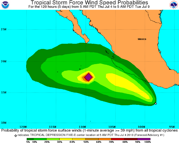
TD 5-E tropical storm force wind speed probabilities map (Credit: NOAA/NHC)
Moderate-to-strong easterly shear is forecast to affect the depression for the next day or so, which will probably not allow for much intensification. A little more strengthening is possible after that time when the shear is forecast to relax a bit while the system remains over warm water. Most of the global models show enough ridging over Mexico to keep the depression offshore.
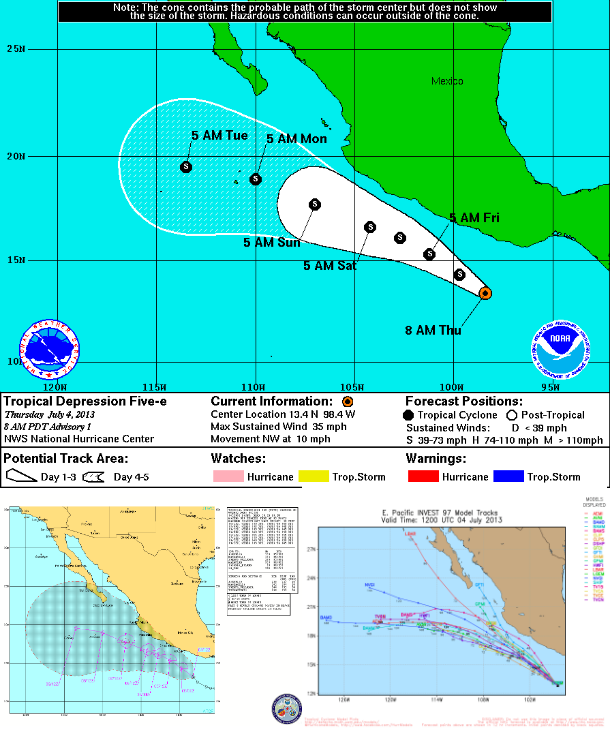
TD 5-E forecast tracks by NHC, JTWC and UWM (Credit: NOAA/NHC/JTWC/UWM)
The center of the depression should move parallel to, but remain offshore, of the coast of southwestern Mexico. Some strengthening is forecast and the depression is expected to become a tropical storm in the next 24 hours. The system will generate rough surf and rip current along the south-central and southwestern coast of Mexico.

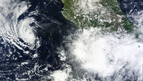
MODIS satellite image showing tropical disturbances in Eastern Pacific region on July 4, 2013 – weakening TS Dalila could be seen on the left (Credit: LANCE Rapid Response/MODIS)
Satellite Animations
- Storm-Centered Infrared (GOES 15; NOAA/SSD)
- Storm-Centered Infrared (Aviation Color Enhancement) (GOES 15; NOAA/SSD)
- Storm-Centered Water Vapor (GOES 15; NOAA/SSD)
- Storm-Centered Visible (GOES 15; NOAA/SSD)
- Storm-Centered Visible (Colorized) (GOES 15; NOAA/SSD)
- Tropical East Pacific Hurricane Sector Infrared (GOES 15; NOAA)
- Tropical East Pacific Hurricane Sector Water Vapor (GOES 15; NOAA)
- Tropical East Pacific Hurricane Sector Visible (GOES 15; NOAA)
Commenting rules and guidelines
We value the thoughts and opinions of our readers and welcome healthy discussions on our website. In order to maintain a respectful and positive community, we ask that all commenters follow these rules.