
Severe weather and polar blast hit New Zealand

Featured image: MODIS satellite image taken on June 21, 2013 (Credit: LANCE/MODIS/Worldview)
New Zealand was hit by the large low pressure system bringing destructive storms that have swept over the country in the last 24 hours, damaging houses, roads and seawalls, as well as closing dozens of schools and leaving thousands without power. Luckily, fierce storm is now showing signs of ease.
Polar blast dumped record early season snow in New Zealand. Heavy snow has fallen in parts of the South Island, cutting off some communities. Areas like North Canterbury and inland parts of northern Southland and Otago have already had some big snow totals.
The deep Antarctic air swept across the country backed by the band of torrential showers – many with hail, thunderstorms and damaging winds. Hail was unusually heavy for Auckland area. A thunderstorm that moved through from the Tasman Sea also caused multiple power outages around the county.
Damaging gales are persisting across areas around Cook Strait, including parts of Wellington. Swells of up to 10 meters have been reported in Cook Strait. Number of houses were losing roofs, windows were breaking and other structural damage was reported. Wellington recorded near record winds of 200 km/h, uprooting trees, downing power lines and ripping off roofs. Severe weather conditions disrupted and canceled flights across the country, with more delays expected as gale force winds are predicted to wallop the lower North Island.
A tornado has been seen in the Waikato community of Paterangi, south of Hamilton on June 20, 2013. Huge size of the wintry blast moving in can still produce tornadoes and squalls in western New Zealand.
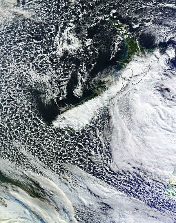
Bands of clouds over east coasts of the both NZ islands captured by MODIS satellite on June 21, 2013 (Credit: LANCE/MODIS/Worldview)
Authorities warned people to remain indoors due to the aggressive nature of the storms coming in from the Tasman Sea, as part of the polar blast hitting New Zealand. Storm-force southerly winds brought down trees and slips in many Wellington suburbs. Driving conditions around the region are treacherous and motorists are urged to stay off the roads unless absolutely necessary.
According to WeatherWatch, the eastern side of both islands will still be in the firing line of a very cold southerly flow that will bring more wintry showers and snow on the hills. After the next 48 hours, an unfavorable weather conditions are expected to move away from the country.
Where will snow fall and what to look out for (MetService)
Snowstorm advice from Civil Defence
Watch NZ Herald's collection of clips taken by Kiwis as an icy storm grips the nation here.
Sources: WeatherWatch, New Zealand Herald, MetService
Commenting rules and guidelines
We value the thoughts and opinions of our readers and welcome healthy discussions on our website. In order to maintain a respectful and positive community, we ask that all commenters follow these rules.