
NASA's computer simulation shows track of Hurricane Sandy
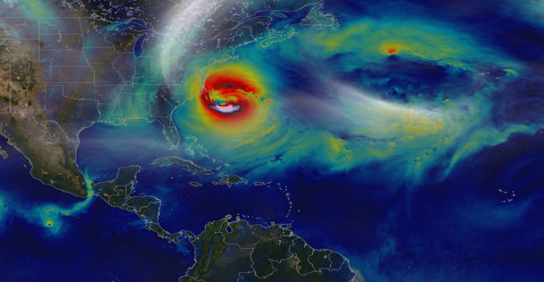
Featured image: A NASA computer model simulates the astonishing track and forceful winds of Hurricane Sandy (Credit: NASA Visualization Explorer)
Hurricane Sandy pummeled the East Coast late in 2012’s Atlantic hurricane season, causing 159 deaths and $70 billion in damages. Days before landfall, forecasts of its trajectory were still being made. Some computer models showed that a trough in the jet stream would kick the monster storm away from land and out to sea. Among the earliest to predict its true course was NASA’s GEOS-5 global atmosphere model.
The model works by dividing Earth’s atmosphere into a virtual grid of stacked boxes. A supercomputer then solves mathematical equations inside each box to create a weather forecast predicting Sandy’s structure, path and other traits. The NASA model not only produced an accurate track of Sandy, but also captured fine-scale details of the storm’s changing intensity and winds.
Source: NASA Visualization Explorer
Commenting rules and guidelines
We value the thoughts and opinions of our readers and welcome healthy discussions on our website. In order to maintain a respectful and positive community, we ask that all commenters follow these rules.