
Study: Hurricane Sandy eroded half of Fire Island's beaches and dunes, New York
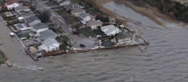
Image credit: TW
New USGS study – beaches and dunes on Fire Island, New York, lost more than half of their pre-storm volume during Hurricane Sandy, leaving the area more vulnerable to future storms.
While the damage and destruction on Fire Island was immediately evident after the storm, this study is the first to quantify the actual changes to the coast caused by the storm.
"The beaches and dunes of the island were severely eroded during Sandy," said Cheryl Hapke, a USGS research geologist and lead author of the study. "The island was breached in three locations, and there was widespread damage and destruction of coastal infrastructure, including private residences. The report shows that the beaches and dunes lost 54.4 percent of their pre-storm volume, and the dunes experienced overwash along 46.6 percent of the island, dramatically changing the island’s shape."
Field surveys conducted immediately after Sandy documented low, flat beaches and extensive dune erosion. Assessment of overwash deposits — the material that was carried to the interior of the island — indicates that most of the sand lost from the beaches and dunes during Hurricane Sandy was moved offshore, carried by waves and storm surge. Of the volume of sand that was lost from the beaches and dunes, 14 percent was deposited inland.
"The impact from Sandy was unprecedented in recent times," said Hapke. "It is important that efforts to rebuild on the island be guided by the science, which shows that Sandy profoundly altered the shape and position of the barrier island, shifting it landward and redistributing large amounts of sand. Storms like Sandy are part of the natural evolution of barrier islands, which ultimately result in islands that are more resilient to sea level rise."
The extreme erosion of the beach and loss of dunes made the island more vulnerable to subsequent winter storms. In the course of the following winter months, the shoreline position shifted as much as 57.5 meters (189 feet) inland. Although several areas begin to experience some recovery in the early spring, at the end of the survey period only a small fraction, 18 percent, of the pre-Sandy beach volume had returned.
"Barrier islands provide natural protection against storms, shielding coastlines from rising waves and tides," said Hapke. "The loss of so much sand increases the vulnerability of this area of coastline to future storms."
Fire Island is the longest of the barrier islands that lie along the south shore of Long Island, New York. The majority of the island is part of Fire Island National Seashore and not only provides the first line of defense against storms, but is a unique and important recreational and ecosystem resource. USGS research on Fire Island focuses understanding the evolution of the form and structure of the barrier system on a variety of time scales, including storm driven change in the region.
- The study can be found here.
Source: USGS
I'm a dedicated researcher, journalist, and editor at The Watchers. With over 20 years of experience in the media industry, I specialize in hard science news, focusing on extreme weather, seismic and volcanic activity, space weather, and astronomy, including near-Earth objects and planetary defense strategies. You can reach me at teo /at/ watchers.news.
Commenting rules and guidelines
We value the thoughts and opinions of our readers and welcome healthy discussions on our website. In order to maintain a respectful and positive community, we ask that all commenters follow these rules.