
Magnitude 6.7 earthquake struck near the South Coast of Papua, Indonesia
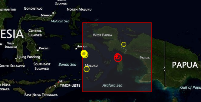
Image credit: TW
A very strong earthquake with recorded magnitude of 6.7 struck near the South Coast of Papua, Indonesia on October 12, 2012 at 00:31 UTC according to USGS and EMSC. Epicenter was located 103 km (64 miles) N of Dobo, Indonesia and 173 km (107 miles) ENE of Tual, Indonesia at coordinates 4.842°S, 134.085°E. Recorded depth by USGS was 24.7 km (15.3 miles), EMSC reports 10 km depth.
There is no threat of widespread tsunami based on historical tsunami and earthquake data. There are about 5000 people living within 100 km.
| Magnitude | 6.7 |
|---|---|
| Date-Time |
|
| Location | 4.842°S, 134.085°E |
| Depth | 24.7 km (15.3 miles) |
| Region | NEAR THE SOUTH COAST OF PAPUA, INDONESIA |
| Distances | 103 km (64 miles) N of Dobo, Indonesia 173 km (107 miles) ENE of Tual, Indonesia 225 km (139 miles) SW of Nabire, Indonesia 439 km (272 miles) S of Manokwari, Indonesia |
| Location Uncertainty | horizontal +/- 12.8 km (8.0 miles); depth +/- 7.3 km (4.5 miles) |
| Parameters | NST=142, Nph=145, Dmin=295 km, Rmss=1.08 sec, Gp= 29°, M-type=regional moment magnitude (Mw), Version=7 |
| Source |
|
| Event ID | usb000d4u2 |

I'm a dedicated researcher, journalist, and editor at The Watchers. With over 20 years of experience in the media industry, I specialize in hard science news, focusing on extreme weather, seismic and volcanic activity, space weather, and astronomy, including near-Earth objects and planetary defense strategies. You can reach me at teo /at/ watchers.news.
Commenting rules and guidelines
We value the thoughts and opinions of our readers and welcome healthy discussions on our website. In order to maintain a respectful and positive community, we ask that all commenters follow these rules.