
Magnitude 6.2 earthquake hit Kepulauan Mentawai Region, Indonesia
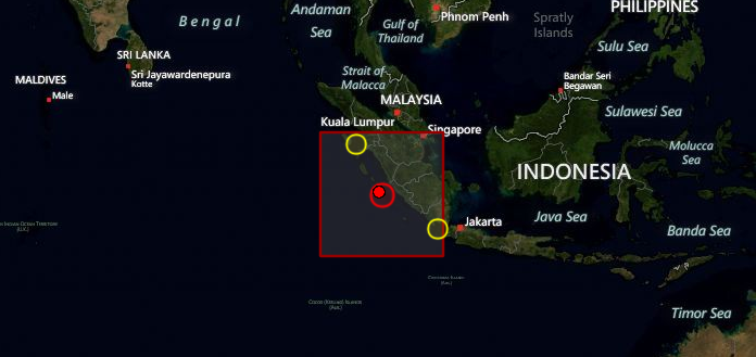
Image credit: TW
6.2 magnitude earthquake hit Kepulauan Mentawai Region, Indonesia on September 14, 2012 at 04:41 UTC according to USGS. Epicenter was located 163 km (101 miles) SSW of Sungaipenuh, Indonesia at coordinates 3.363°S, 100.588°E; 760 km (470 miles) west-northwest of the capital, Jakarta. Recorded depth by USGS was 19.8 km (12.3 miles). EMSC is reporting magnitude 6.0 earthquake and depth of 10 km.
GDACS reported that this earthquake can have a low humanitarian impact based on the Magnitude and the affected population and their vulnerability. There are about 49 000 people within 100 km.
The intensity of the quake was felt at 3 to 4 MMI (Modified Mercally Intensity) at Padang city, the provincial capital of West Sumatra, Indonesian Meteorology and Geophysics Agency said.
Indonesia is vulnerable on earthquake and volcanoes as it lies on quake-hit zone “the Pacific Ring of Fire.”
| Magnitude | 6.2 |
|---|---|
| Date-Time |
|
| Location | 3.363°S, 100.588°E |
| Depth | 19.8 km (12.3 miles) |
| Region | KEPULAUAN MENTAWAI REGION, INDONESIA |
| Distances | 163 km (101 miles) SSW of Sungaipenuh, Indonesia 190 km (118 miles) WNW of Bengkulu, Indonesia 214 km (132 miles) W of Curup, Indonesia 250 km (155 miles) W of Lubuklinggau, Indonesia |
| Location Uncertainty | horizontal +/- 11.6 km (7.2 miles); depth +/- 3 km (1.9 miles) |
| Parameters | NST=521, Nph=564, Dmin=285 km, Rmss=0.88 sec, Gp= 22°, M-type=teleseismic moment magnitude (Mw), Version=E |
| Source |
|
| Event ID | usc000cnlk |

I'm a dedicated researcher, journalist, and editor at The Watchers. With over 20 years of experience in the media industry, I specialize in hard science news, focusing on extreme weather, seismic and volcanic activity, space weather, and astronomy, including near-Earth objects and planetary defense strategies. You can reach me at teo /at/ watchers.news.
Commenting rules and guidelines
We value the thoughts and opinions of our readers and welcome healthy discussions on our website. In order to maintain a respectful and positive community, we ask that all commenters follow these rules.