
Tropical Storm Bolaven formed in western north Pacific
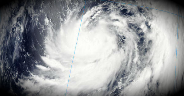
Image credit: TW
Tropical Depression 16W become Tropical Storm Bolaven and took more of a rounded shape on August 20. Bolaven continued to organize and intensify in the western north Pacific waters. Bolaven will continue to intensify as environmental conditions remain favorable.

According to latest report by Joint Typhoon Warning Center (JTWC), Tropical Storm Bolaven (16W) was located about 410 nm south of Iwo To, Japan and was moving west-northwestward ar speed of 3 knots. Maximum significant wave heights are 14 feet.


Bolaven will continue strengthening as it moves to the west-northwest over the next couple of days in open waters of the western North Pacific Ocean. By August 24 forecasters at the Joint Typhoon Warning Center expect Bolaven to reach typhoon status. Taiwan could be affected by Bolaven.
Tropical Storm Bolaven was born over the weekend of August 18-19 in the western North Pacific.


Satellite Animations
- Storm-Centered Infrared (MTSAT; NOAA/SSD)
- Storm-Centered Infrared (Aviation Color Enhancement) (MTSAT; NOAA/SSD)
- Storm-Centered Water Vapor (MTSAT; NOAA/SSD)
- Storm-Centered Visible (MTSAT; NOAA/SSD)
- Storm-Centered Visible (Colorized) (MTSAT; NOAA/SSD)
- Tropical West Pacific Infrared (MTSAT2; NOAA)
- Tropical West Pacific Enhanced Infrared (MTSAT2; NOAA)
- Tropical West Pacific Water Vapor (MTSAT2; NOAA)
- Tropical West Pacific Visible (MTSAT2; NOAA)
Commenting rules and guidelines
We value the thoughts and opinions of our readers and welcome healthy discussions on our website. In order to maintain a respectful and positive community, we ask that all commenters follow these rules.