
Very strong magnitude 7.3 earthquake near northern Sumatra, Indonesia
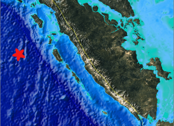
Image credit: TW
Very strong 7.3 earthquake hit Sumatra at 18:37:01 UTC. According to USGS, an epicenter was located 423 km (262 miles) SW of Banda Aceh, Sumatra, 537 km (333 miles) SW of Lhokseumawe, Sumatra and 951 km (590 miles) W of Kuala Lumpur, Malaysia (2.396°N, 93.175°E) at depth of 29.1 km (18.1 miles). EMSC registered same magnitude but the depth was 10km (6.2 miles). EMSC readings were at first 7.5 magnitude. Indonesian media are currently reporting a magnitude of 7.6 and only reporting earthquake numbers , no background information yet.

There was no tsunami warnings issued by Pacific Tsunami Warning Center but the local BMKG has called a TSUNAMI ALERT for parts of the country. There are no islands within hundreds of kilometers from the epicenter. GDACS has calculated based on historical earthquakes and lots of additional data, that the waves in Northern Sumatra will be max. 0.4 meter


Commenting rules and guidelines
We value the thoughts and opinions of our readers and welcome healthy discussions on our website. In order to maintain a respectful and positive community, we ask that all commenters follow these rules.