
Irene seen by TRMM and MODIS satellites strengthnening into Category 1 hurricane
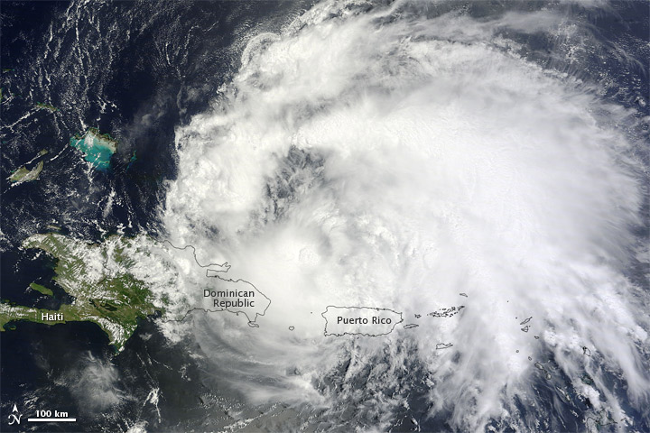
Image credit: TW
Irene formed as a tropical storm east of the Leeward Islands on August 20, 2011. By August 22, the storm had strengthened to a Category 1 hurricane. At 2:00 p.m. Atlantic Standard Time on August 22, the U.S. National Hurricane Center (NHC) reported that Irene had maximum sustained winds of 80 miles (130 kilometers) per hour, with higher gusts. The storm was located about 150 miles (240 kilometers) west-northwest of San Juan, Puerto Rico.
The Moderate Resolution Imaging Spectroradiometer (MODIS) on NASA’s Terra satellite captured this natural-color image at 11:20 a.m. local time (15:20 UTC) on August 22. Storm clouds cover part of the Dominican Republic, and all of Puerto Rico.
As of August 22, Irene had cut power to more than a million residents of Puerto Rico. Heavy rains had pushed at least five rivers over their banks on the island. Citing continuing rains, downed power lines, and potential landslides, the Puerto Rico governor urged residents to stay indoors.
Moving westward to the island of Hispaniola, Irene menaced the Dominican Republic and Haiti. The storm’s worst winds and rains remained north of the island, reducing the threat of deadly flooding. Nevertheless, authorities worried about approximately 600,000 Haitians still living in Port Au Prince tent cities after the 2010 earthquake.
The NHC reported that a hurricane warning was in effect for the north coast of the Dominican Republic, the southeastern Bahamas, and the Turks and Caicos Islands. A hurricane watch was in effect for the north coast of Haiti. Irene was moving toward the west-northwest at roughly 12 miles (19 kilometers) per hour, and was expected to continue in that direction for the next day or two.
Five-day projections released by the NHC on August 22 showed Irene heading for the continental United States, potentially making landfall in Florida, Georgia, or the Carolinas. (EarthObservatory)
Hurricane Irene heads toward Hispaniola and U.S
Irene could become major hurricane; Bahamas, U.S. at risk
Hurricane Irene Advisory Archive
The 2011 Atlantic hurricane season has been busy so far in terms of tropical storms with seven named storms; however, none of them have had a very large impact. Each has been small, short-lived or remained at sea, and none have intensified into a hurricane until Irene reached hurricane status on August 22.

The Tropical Rainfall Measuring Mission (TRMM) satellite passed directly over Irene as the storm moved westward toward the Dominican Republic from Puerto Rico. The images were taken at 15:57 UTC (11:57 AM EDT) on August 22, 2011.
Rain rates in the center of the swath are from the TRMM Precipitation Radar and those in the outer swath are from the TRMM Microwave Imager. The rain rates are overlaid on infrared data from the TRMM Visible Infrared Scanner.

Irene is expected to turn to the northwest towards the central Bahamas and intensify where it could become a major hurricane.
Irene, which originated from a tropical wave that propagated off the west coast of Africa, became the 8th named storm of the season as it approached the Lesser Antilles on August 20 and the first hurricane of the season as it was passing over Puerto Rico on the morning of the 22nd. Now back over open water, Irene is poised to pass close to the northern coast of Hispaniola and poses a threat to the Bahamas.
TRMM is a joint mission between NASA and the Japanese space agency JAXA. (EarthObservatory)
Click to see a 3-D animation of TRMM PR
Click here to see earlier TRMM information about Irene
Commenting rules and guidelines
We value the thoughts and opinions of our readers and welcome healthy discussions on our website. In order to maintain a respectful and positive community, we ask that all commenters follow these rules.