
Typhoon “Yutu” (Rosita) to hit Isabela and Aurora, traverse over Quirino, Ifugao, Nueva Vizcaya, Benguet and La Union, Philippines

Featured image: Typhoon "Yutu" (Rosita) at 13:00 UTC on October 29, 2018. Credit: JMA/Himawari-8, RAMMB/CIRA
The center of Typhoon "Yutu," known in the Philippines as Rosita, is just east of Luzon at 16:00 UTC, October 29. Yutu is expected to make landfall over Southern Isabela – Northern Aurora area by the end of the UTC day (05:00 – 07:00 local time, October 30) with maximum sustained winds of 150 km/h (92 mph). This would make it a Category 2 hurricane equivalent on the Saffir-Simpson scale. Storm surge up to 3 m (10 feet) is possible over some coastal areas along with moderate to heavy rain across Northern and Central Luzon.
As of 23:00 local time, October 29 (15:00 UTC):
Tropical Cyclone Warning Signal (TCWC) no. 1 is in effect for Southern Quezon, Batanes and Babuyan group of Islands, Rizal, Metro Manila, Laguna, Batangas, Bataan, Cavite, and Camarines Norte, Luzon.
Winds of 30 – 60 km/h (18 – 37 mph) may be expected in at least 36 hours or intermittent rains may be expected within 36 hours.
TCWC no. 2 is in effect for Cagayan, Ilocos Norte, Apayao, Abra, Kalinga, Tarlac, Nueva Ecija, Northern Quezon including Polillo Island, Southern Aurora, Zambales, Pampanga and Bulacan, Luzon.
Winds greater than 61 km/h (38 mph) and up to 120 km/h (75 mph) may be expected in at least 24 hours.
TCWC no 3. is in effect for Isabela, Quirino, Northern Aurora, Nueva Vizcaya, Ifugao, Benguet, La Union, Ilocos Sur, Mountain Province, and Pangasinan, Luzon.
Winds of greater than 121 km/h (75 mph) up to 170 km/h (105 mph) may be expected in at least 18 hours.
Impact of the wind (TCWC 3)
- Many coconut trees may be broken or destroyed.
- Almost all banana plants may be downed and a large number of trees may be uprooted.
- Rice and corn crops may suffer heavy losses.
- Majority of all nipa and cogon houses may be unroofed or destroyed and there may be considerable damage to structures of light to medium construction.
- There may be widespread disruption of electrical power and communication services.
- In general, moderate to heavy damage may be experienced, particularly in the agricultural and industrial sectors.
Precautionary measures (TCWC 3)
- The disturbance is dangerous to the communities threatened/affected.
- The sea and coastal waters will be very dangerous to all seacrafts.
- Travel is very risky especially by sea and air.
- People are advised to seek shelter in strong buildings, evacuate low-lying areas and to stay away from the coasts and river banks.
- Watch out for the passage of the "eye" of the typhoon indicated by a sudden occurrence of fair weather immediately after very bad weather with very strong winds coming gnerally from the north.
- When the "eye" of the typhoon hit the community do not venture away from the safe shelter because after one to two hours the worst weather will resume with the very strong winds coming from the south.
- Classes in all levels should be suspended and children should stay in the safety of strong buildings.
- Disaster preparedness and response agencies/organizations are in action with an appropriate response to actual emergency.
What to do (TCWC 3)
- If the house is not strong enough to withstand the battering of strong winds go to designated evacuation center aor seek shelter in stronger houses.
- Stay in safe houses until after the disturbances have left the area.
- Evacuate from low-lying area and reiverbanks and stay away from coastal areas for possible flooding and strom surge.
- All travel and outdoor activities should be canceled.
- Watch out for the passage of the "Eye Wall and the "Eye" of the typhoon.
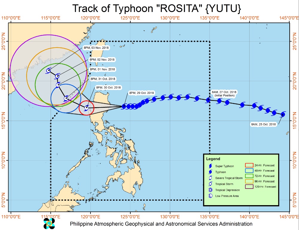
Typhoon "Yutu" (Rosita) at 13:00 UTC on October 29, 2018. Credit: JMA/Himawari-8, RAMMB/CIRA
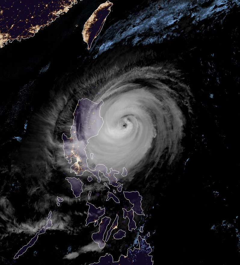
At 14:00 UTC on October 29 (22:00 LT), the center of Typhoon "Yutu" was located about 190 km (118 miles) ENE of Casiguaran, Aurora, Philippines. The typhoon is moving west at 20 km/h (12 mph) with maximum sustained winds of 150 km/h (93 mph) and gusts to 185 km/h (115 km/h).
"Moderate to heavy rains directly associated with the typhoon are expected over Northern and Central Luzon starting tonight (October 29 LT)," PAGASA said.
Residents in these areas, especially those living near river channels, in low-lying areas and mountainous areas, are advised to take appropriate actions against possible flooding and landslides, coordinate with the local disaster risk reduction and management offices.
Storm surge of up to 3 m (10 m) is possible over the coastal areas of Isabela, Cagayan, Aurora, Ilocos Sur, Ilocos Norte and La Union.
Fisherfolks and those with small seacrafts are advised not to venture out over the seaboards of areas with TCWS and Eastern and Western seaboards of Southern Luzon, Eastern seaboards of Visayas, and Mindanao.
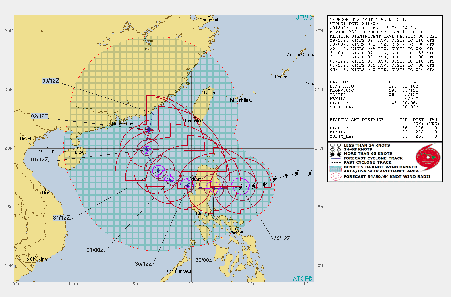
Landfall is expected over Southern Isabela – Northern Aurora area by tomorrow morning local time (05:00 – 07:00 LT, October 30 / 21:00 – 23:00 UTC, October 29). The typhoon will then traverse Aurora, Isabela, Quirino, Ifugao, Nueva Vizcaya, Benguet and La Union.
Exit landmass is expected by October 30 afternoon (LT, -8UTC).
Yutu underwent explosive intensification after it was born on October 21 and made landfall in Tinian and Saipan, Northern Mariana Islands on October 24 as the most powerful storm on record to impact the islands – maximum sustained winds 285 km/h (180 mph).
A woman was killed in Saipan after Yutu wrecked the building she was staying in. At least 133 people were injured, 3 of them severely. More than 200 power poles were knocked down on Saipan and Tinian. Most buildings on both islands had their roofs destroyed.
I'm a dedicated researcher, journalist, and editor at The Watchers. With over 20 years of experience in the media industry, I specialize in hard science news, focusing on extreme weather, seismic and volcanic activity, space weather, and astronomy, including near-Earth objects and planetary defense strategies. You can reach me at teo /at/ watchers.news.
Commenting rules and guidelines
We value the thoughts and opinions of our readers and welcome healthy discussions on our website. In order to maintain a respectful and positive community, we ask that all commenters follow these rules.