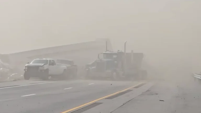
• Santa Ana winds bring damaging gusts up to 70 mph, elevate fire weather concerns across Southern California

    Strong Santa Ana winds intensified across Southern California on Friday, January 9, 2026, prompting the National Weather Service to issue high wind warnings and advisories for mountain, valley, and coastal regions. Gusts reaching up to 115 km/h (70 mph) were recorded in canyon and foothill areas, raising risks of power outages, tree damage, and hazardous travel conditions through the weekend.

  • Remnant Alaska atmospheric river to merge with second plume, bringing prolonged AR conditions to western Washington

    An atmospheric river that impacted Alaska on January 9, 2026, is forecast to propagate down the coast and merge with a second plume, delivering a 48–72-hour period of AR conditions over western Washington from January 10 to 12. Forecast guidance indicates 100–150 mm (4–6 inches) of rain over the Olympic Peninsula, 50–100 mm (2–4 inches) over the northern Washington Cascades, and 25–50 mm (1–2 inches) over the Cascade foothills, with freezing levels rising above 1 830 m (6 000 feet).

  • Tornadoes touch down in Mississippi as severe storms sweep across the state

    Multiple tornadoes touched down in Mississippi on January 9, 2026, as a powerful storm system moved through the Deep South, producing damaging winds and heavy rainfall. The U.S. National Weather Service issued Tornado and Flash Flood Watches for large portions of the state, warning of further severe storms through January 10 as the system continues eastward.

  • Freeze warnings in effect across southern Arizona, southeastern California, and southern Nevada

    Freeze warnings remain in effect across much of southern Arizona, southeastern California, and southern Nevada through the morning of Saturday, January 10, 2026. Temperatures are forecast to fall below freezing across several valleys and desert regions, including the Tucson and Phoenix metropolitan areas, the Las Vegas Valley, and the Upper Gila River and San Pedro valleys. The National Weather Service warns that these conditions could kill crops, damage sensitive vegetation, and affect exposed plumbing.

  • Damaging tornado hits Purcell, Oklahoma, destroying multiple structures

    Two radar-confirmed tornadoes struck parts of Oklahoma on January 8, 2026, one near Purcell in McClain County at 07:31 LT and another south of Stella in Cleveland County at 07:45 LT. The storms damaged and destroyed multiple structures in Purcell and left more than 3 500 customers without power.

  • Extreme cold warning issued for parts of the Bay Area and Central Coast, California

    An Extreme Cold Warning was issued for parts of the San Francisco Bay Area, California, including interior Monterey County, San Benito County, and the eastern Santa Clara Hills. The warning will be in effect from 01:00 to 09:00 PST on January 9, 2026. Temperatures are forecast to drop below freezing, posing hazards to unhoused populations, livestock, and sensitive crops.

  • Extreme Cold Warning issued for parts of Alaska

    An Extreme Cold Warning remains in effect across western and southwestern Alaska until 18:00 AKST (03:00 UTC) on January 10, 2026, affecting the Lower Kuskokwim Valley, Kuskokwim Delta, Bristol Bay region, and the Alaska Peninsula. Wind chills are forecast to drop to −40 to −60°C (−40 to −76°F), with slightly higher values near Pilot Point and Port Heiden.

  • Twin cross-country storms to bring severe weather from the Cascades and Rockies to the Mississippi Valley

    A pair of cross-country storm systems will affect large parts of the United States through Friday, January 9, 2026, bringing widespread rain, mountain snow, and a risk of severe thunderstorms. Heavy snowfall is forecast for the Cascades and the southern Rockies. Flash floods and severe thunderstorms are forecast across the Lower Mississippi and Tennessee Valleys by the end of the week.

  • Winter Storm Warnings in effect for Washington, Oregon, Idaho, and Montana through Thursday

    A major winter storm is affecting the Pacific Northwest and northern Rockies, with winter storm warnings in effect through 16:00 PST on Thursday, January 8, 2026. Heavy snow is forecast to continue across the Cascades of Washington and Oregon, extending into Idaho and western Montana. Snow accumulations are forecast to reach between 30 cm and 120 cm (1 to 4 feet), with gusts up to 80 km/h (50 mph) causing whiteout conditions and difficult travel across mountain passes.