
Heavy rainfall and severe storms forecast from Texas to the Carolinas this Valentine’s weekend
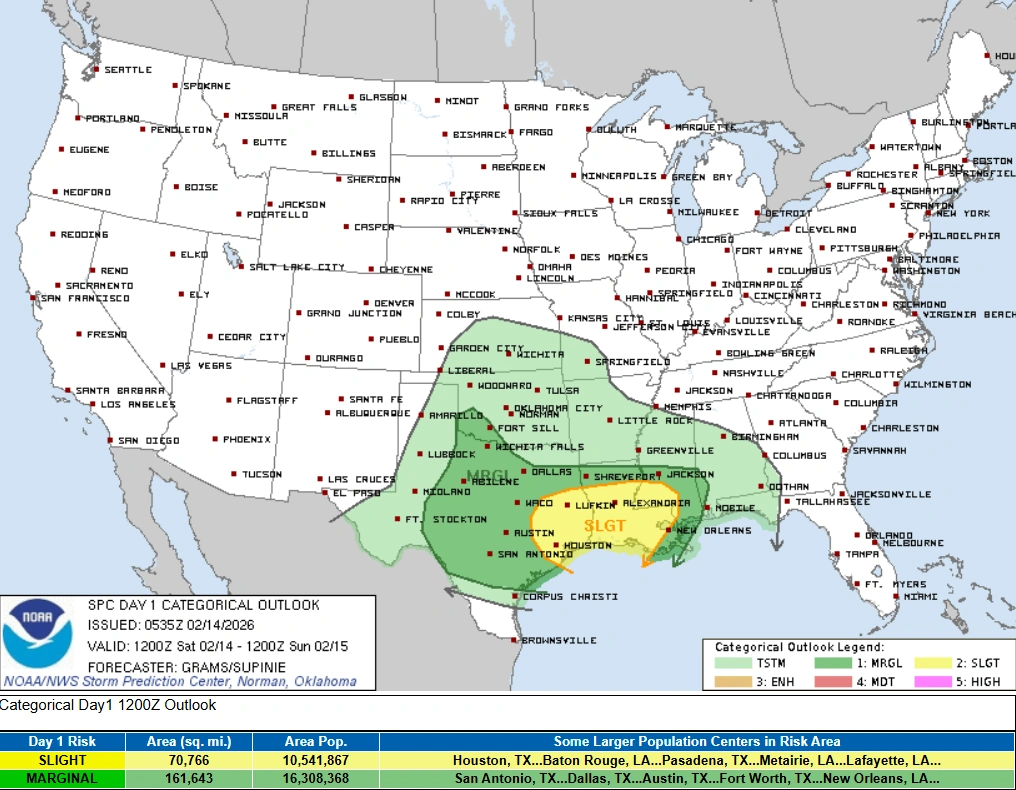
A storm moving from the Southern Plains into the Southeast will generate widespread showers, locally heavy rainfall, and severe thunderstorms across the southern and eastern United States through February 16, 2026. Slight Risk areas for Severe Thunderstorms and Excessive Rainfall extend from east Texas into the lower Mississippi Valley, with additional Marginal Risk areas across the Southeast and Mid-Atlantic.
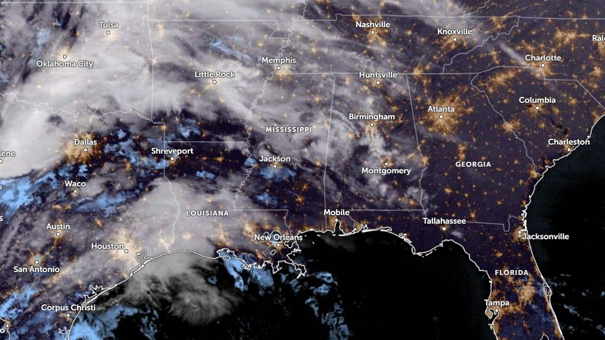
Satellite image of southeastern U.S. and Gulf Coast at 11:40 UTC on February 14, 2026. Credit: NOAA/GOES-19, Zoom Earth The Watchers
A surface low over the Southern Plains is forecast to move into the Southeast by February 15 as a trailing cold front advances toward the East Coast.
As the system moves into the lower Mississippi Valley, the front will interact with lingering Gulf moisture; it could produce widespread showers and thunderstorms stretching into the Southeast.
The Weather Prediction Center (WPC) has placed parts of ArLaTex in the Mid-South under a Slight Risk of Excessive Rainfall for February 14–15.
Thunderstorms along the frontal boundary could bring locally heavy rainfall, with flash flooding possible, with parts of the Southeast and the Mid-Atlantic being under a Marginal Risk of Excessive Rainfall from February 15–16 as the system progresses northeast.
The Storm Prediction Center (SPC) has issued a Slight Risk of Severe Thunderstorms from east Texas into the lower Mississippi Valley. Severe thunderstorms are most likely this evening into tonight across east Texas to southern Mississippi, where a few tornadoes and scattered damaging winds may occur.
Forecast models suggest that by the evening of February 14, storms could organize into a stronger line across eastern Texas. This line is expected to move quickly east overnight into Louisiana and the lower Mississippi Valley.
Parts of the storm line could produce damaging winds, and there is an increasing chance for brief tornadoes embedded within the line. A few individual storms may form closer to the Gulf Coast before merging into the main line.
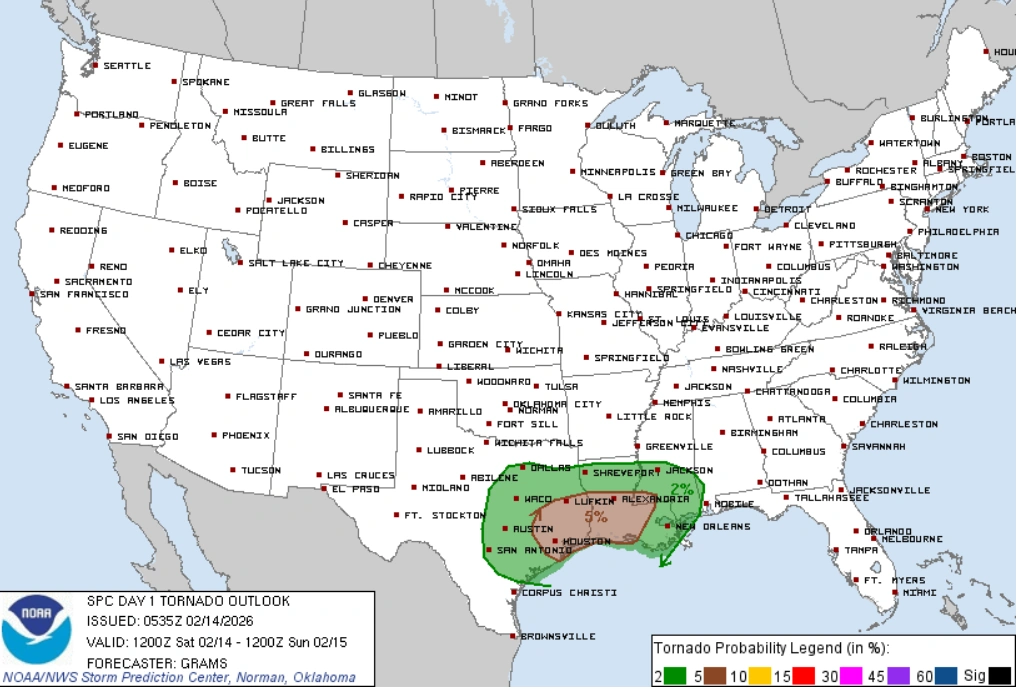
The storm system may weaken somewhat by the morning of February 15 as its strongest energy shifts north. However, locally damaging winds and a brief tornado remain possible near parts of the central Gulf Coast through the end of the period.
A separate storm system is forecast to move inland from the Gulf of Alaska into the Pacific Northwest during the same period. Precipitation chances will increase across Washington, Oregon, and the Intermountain West. Light to moderate snowfall may develop over the Northern Rockies on February 14 as moisture moves eastward.
On February 15–16, as a trough deepens over California and a surface cold front approaches the coast, rain chances will increase across coastal and interior Northern California. As moisture moves over higher terrain, moderate to heavy snowfall is expected to develop across the Sierra through February 15-16.

I am an Assistant Editor and Severe Weather & Science Journalist at The Watchers, specializing in real-time severe weather coverage, geophysical event reporting, and research-driven scientific analysis. You can reach me at rishav(at)watchers(.)news.
Commenting rules and guidelines
We value the thoughts and opinions of our readers and welcome healthy discussions on our website. In order to maintain a respectful and positive community, we ask that all commenters follow these rules.