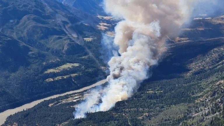
• Saskatchewan records first tornado of 2026, Canada

    The Northern Tornadoes Project confirmed Saskatchewan’s first tornado of 2026 after an EF0 landspout touched down near Disley, west of Regina, on May 22, while additional surveys in Ontario and Alberta raised Canada’s confirmed tornado count to 11 this year.

  • Major late-season winter storm forecast to bring up to 50 cm (20 inches) of snow and freezing rain to northern Manitoba, Canada

    A major late-season winter storm is forecast to impact northern Manitoba, Canada, beginning Wednesday evening, April 22, 2026, bringing 30–50 cm (12–20 inches) of snow, freezing rain, and strong winds. The system will produce rain or freezing rain across central regions before transitioning to heavy snow through Saturday, creating hazardous travel conditions and increasing the risk of power outages.

  • Widespread snow, freezing rain, and strong winds forecast as cross-country storm impacts Canada

    A cross-country storm is forecast to affect multiple regions of Canada from March 23 through midweek, bringing snow to western and central areas before spreading mixed precipitation and stronger impacts into parts of Ontario, Quebec, and Atlantic Canada. The highest-confidence snowfall totals, reaching 20 to 40 cm (8 to 16 inches) in parts of Newfoundland and elsewhere in Atlantic Canada, are expected to create hazardous travel conditions, reduced visibility, and local transport disruptions.

  • Prolonged atmospheric river brings Flood Watch and high avalanche danger to British Columbia as some areas face up to 400 mm (15.7 inches) of rain

    A prolonged atmospheric river is affecting British Columbia this week, with Flood Watch, multiple rainfall warnings, and Special Weather Statements in effect across parts of the province. Some coastal areas could receive up to 400 mm (15.7 inches) of rain, while heavy rain on existing snowpack is increasing the risk of flooding, washouts, landslides and dangerous avalanche conditions.

  • Canada records lowest temperature in decades and record snowfall in winter 2025–26

    Canada recorded its lowest temperature in decades during winter 2025–26, with −55.7°C (−68°F) measured at Braeburn, Yukon, on December 23. Seasonal snowfall reached 446 cm (176 inches) in Gander West, Newfoundland and Labrador, among the highest totals reported nationwide this winter, while Toronto registered its snowiest single day on record on January 25, when 46 cm (18 inches) fell at Toronto Pearson International Airport. The season, spanning December 1, 2025, through February 28, 2026, saw a 76.7°C (138°F) national temperature range, repeated Arctic air outbreaks, and major winter storms that disrupted transportation across central and eastern Canada.

  • Series of multi-vehicle collisions shut down parts of Highway 401 in Ontario

    A series of multi-vehicle collisions involving about 50 vehicles shut down sections of Highway 401 in eastern Ontario, Canada, on the morning of January 27, 2026, according to the Ontario Provincial Police. The crashes occurred near Trenton in Quinte West, forcing a full closure of the highway in both directions as emergency crews responded.

  • Toronto Pearson sets all-time daily snowfall record as January 2026 becomes snowiest month since records began, Canada

    A powerful winter storm delivered record-breaking snowfall across Toronto, Ontario, Canada, on January 25, 2026, with 46 cm (18.1 inches) measured at Toronto Pearson International Airport as of 05:00 LT on January 26. This marks the highest single-day snowfall recorded since observations at the airport began in 1937. The event established new daily and monthly records for the site and caused widespread disruption across the Greater Toronto Area.

  • Major polar vortex disruption brings Arctic surges across North America and Europe through January and early February

    A major polar vortex disruption has begun and is forecast to send Arctic air into much of North America and Europe through mid and late January 2026. The event will bring freezing temperatures and winter weather as the vortex weakens following a stratospheric warming episode. A second, stronger outbreak is forecast to occur during the last part of January as the core of the vortex splits into two halves, each driving cold Arctic air into Europe and North America in February.