
Wildfire smoke and extreme heat can make safety measures conflict, NASA-funded project examines solutions
A NASA-supported research partnership is examining how wildfire, smoke and extreme heat affect Pacific Northwest communities when the hazards occur together, including situations in which protection from one exposure can complicate protection from another. The project was announced by Michigan News on August 11, 2026, and involves researchers and public-health partners in Michigan, Oregon and Wyoming working toward tools for communities preparing for combined hazards.

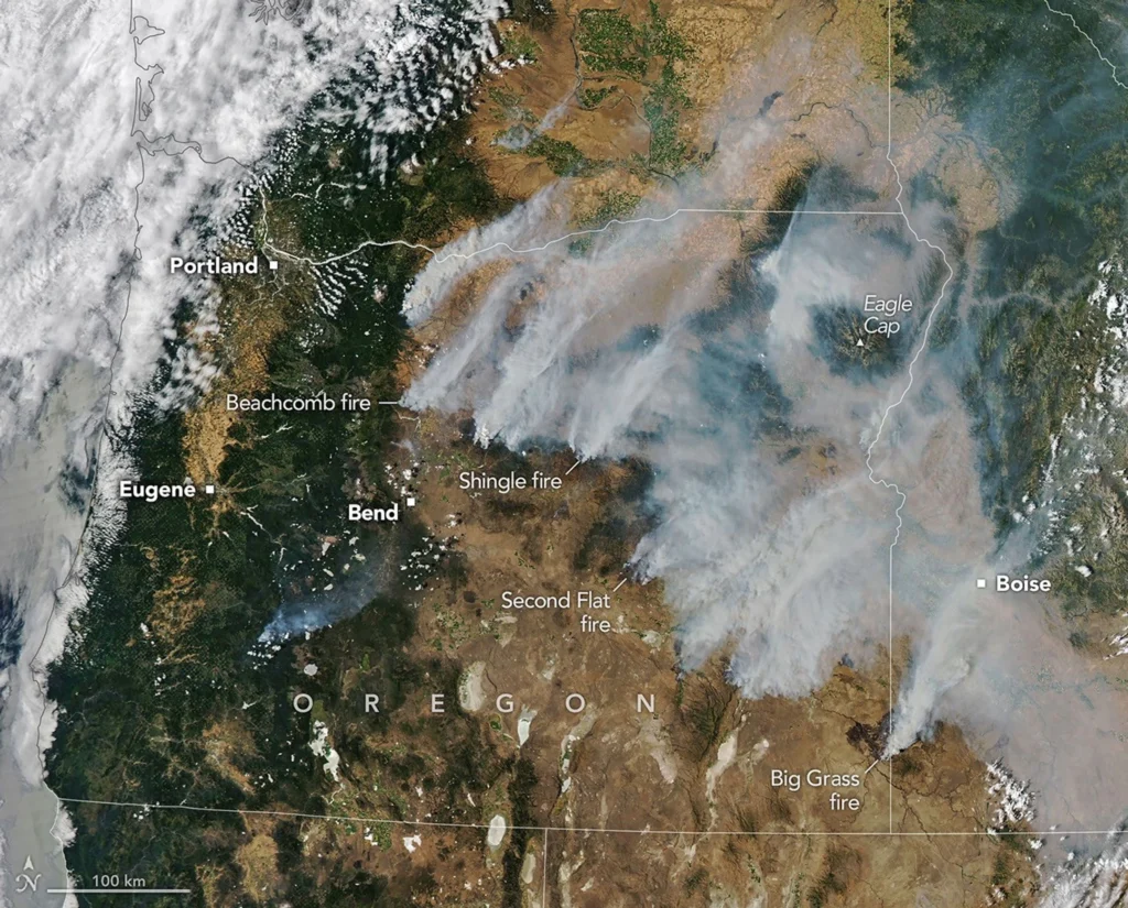
Smoke pours from dozens of large fires in Oregon in this image captured by MODIS (Moderate Resolution Imaging Spectroradiometer) on NASA's Aqua satellite on July 26, 2026. Credit: NASA Earth Observatory/Michala Garrison
The University of Michigan team is working with the Oregon Health Authority, University of Oregon, and University of Wyoming. Researchers are focusing in part on older adults, pregnant people, people with chronic illnesses and outdoor workers, groups identified by the university as sensitive to the combined effects of wildfire, smoke and extreme heat. The Michigan team includes School for Environment and Sustainability Associate Professor Alexandra “Paige” Fischer.
The protection problem changes when the hazards occur at the same time. Wildfire smoke can make cleaner indoor air preferable to prolonged outdoor exposure, while extreme heat raises the danger of remaining in buildings that cannot stay adequately cool. Michigan News frames the project around that conflict, including situations in which indoor shelter provides limited protection because adequate cooling or filtration is unavailable.
One part of the project combines computer models with satellite and demographic data to predict which areas and communities face the greatest risk from simultaneous fire, smoke and heat exposure. The work is intended to translate those results into decision-making tools communities can use when the hazards coincide. University of Michigan material describes risk prediction and decision support; it does not describe an existing operational forecast system for simultaneous wildfire, smoke and extreme heat.
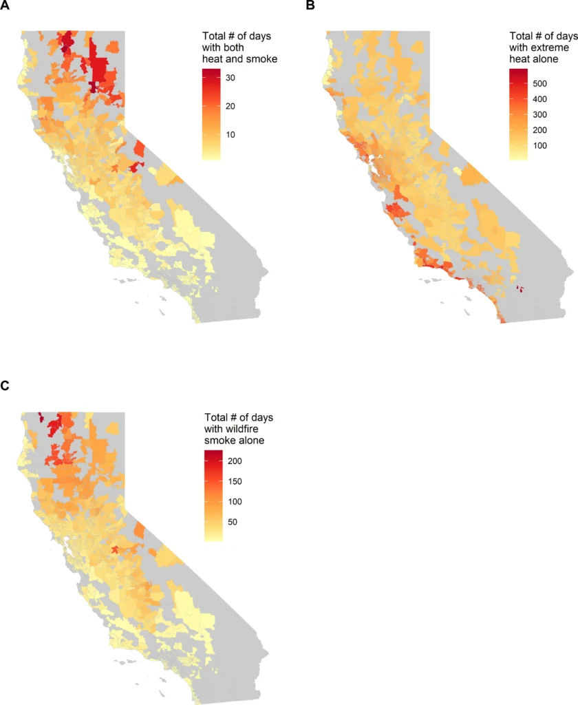
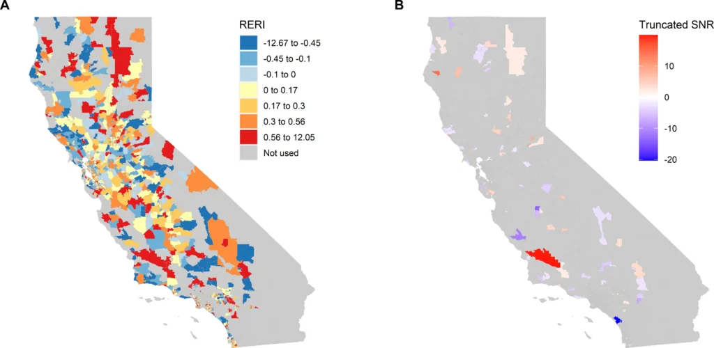
Peer-reviewed epidemiological research has already examined the health effects of exposure to smoke and extreme heat occurring together. Chen et al. (2024) analyzed California communities from 2006 through 2019 and reported synergistic effects between extreme heat and wildfire smoke on daily cardiorespiratory hospitalizations, with the strength of the combined association varying geographically. The study appeared in Science Advances and analyzed the hazards jointly rather than treating their effects only as separate exposures.
Chen et al. also found that the strength of the combined association differed among communities. Lower educational attainment, lower income, lower health-insurance coverage and other measures of social vulnerability were associated with stronger synergistic effects in parts of the study area. The new Pacific Northwest project similarly incorporates demographic data when identifying communities at risk from combined fire, smoke and heat exposure.
Compound-exposure studies combine environmental and population datasets across the same locations and periods. Smoke exposure can be characterized using satellite observations and air-quality measurements, while extreme-heat exposure requires temperature-based definitions; demographic datasets then describe characteristics of the populations within affected areas.
Chen et al. analyzed qualifying California ZIP Code Tabulation Areas over a 2006–2019 study period, while the Michigan-led project is described as combining computer models, satellite information, and demographic data for Pacific Northwest risk assessment and decision support.
Buildings form part of the wider exposure environment because protection from outdoor smoke and extreme heat depends partly on indoor air quality and temperature. The Fifth National Climate Assessment reports that access to heating, ventilation and air-conditioning systems and air filtration can improve indoor air quality and reduce wildfire-smoke exposure in the Northwest. It also identifies unequal access to air conditioners, air purifiers and adequately protected housing as a factor in climate-related health vulnerability.
Cooling and filtration also connect the health problem to regional energy demand. The Fifth National Climate Assessment reports that rising temperatures and heatwaves are changing the timing and geographic pattern of electricity demand in the Northwest, while increasing cooling degree days are associated with higher cooling demand and potential energy shortfalls. The assessment also states that broader use of air conditioning and filtration can place additional pressure on energy supplies.
Wildfire creates another electricity-system interaction. The Fifth National Climate Assessment states that transmission and distribution infrastructure can both contribute to wildfire ignition risk and be exposed to wildfire, while some Northwest utilities use public-safety power shutoffs or fast-trip programs to reduce ignition risk under hazardous conditions. Those measures can interrupt electricity service.
The Michigan project description, however, does not state that researchers are modeling blackout probability or power-system failure, so grid impacts remain regional context rather than a reported output of the NASA-supported work.
The Fifth National Climate Assessment describes Northwest infrastructure systems as complex and interrelated and documents situations in which adaptation in one system can place additional stress on another. It also identifies outdoor workers and communities with fewer resources as disproportionately exposed to hazards including wildfire smoke and extreme heat.
That wider infrastructure and vulnerability context helps define the conditions under which compound exposure becomes a public-health problem without assigning those infrastructure outcomes directly to the Michigan project.
The University of Michigan project focuses its decision-support work on identifying where fire, smoke and extreme heat overlap with exposed populations and on improving recommendations for communities facing those hazards together.
Its stated emphasis on older adults, pregnant people, people with chronic illnesses and outdoor workers gives the project a defined population focus rather than treating exposure as geographically or socially uniform.
References:
1 How do you protect yourself when fire, smoke and heat combine? – Michigan News, University of Michigan – August 11, 2026
2 Chen, C., Schwarz, L., Rosenthal, N., Marlier, M. E., & Benmarhnia, T. (2024). Exploring spatial heterogeneity in synergistic effects of compound climate hazards: Extreme heat and wildfire smoke on cardiorespiratory hospitalizations in California. Science Advances, 10(5). https://doi.org/10.1126/sciadv.adj7264

I’m a science journalist and researcher at The Watchers, contributing to the Epicenter edition, where I cover peer-reviewed scientific research and emerging discoveries across Earth and space sciences. With a background in astronomy and a passion for environmental science, I’ve worked in shark and coral conservation in Fiji, conducting reef and shark-behavior research, contributing to mangrove restoration, and earning PADI Open Water and Coral Reef Certifications. I bring a blend of scientific rigor and storytelling to illuminate the discoveries shaping our planet and beyond.
Published in the last 24 hours
- A fireball over northern China on 6 November 2026 punched a crater into a wheat field at Beigucheng village in Hebei; the Institute of Geochemistry has now classified the fallen stones as L6 ordinary chondrites. Epicenter
- Weather radar tracked meteorites falling into Cape Cod Bay after a 1.1-kiloton fireball over Massachusetts on 30 May 2026; researchers have now traced its orbit almost out to Jupiter. Epicenter
- 10 named storms, one hurricane for the first time since 1925: Why has the Atlantic been so quiet in 2026 Epicenter
- Bay of Bengal system to become Cyclone Akvan, landfall forecast between Nellore and Tuni on November 20, India
