
Teleconnections link Earth’s weather into one global climate system
Teleconnections are patterns in the atmosphere and oceans that link weather and climate anomalies across long distances, allowing conditions in one region, including the Pacific Ocean, to influence rainfall and temperature patterns elsewhere.
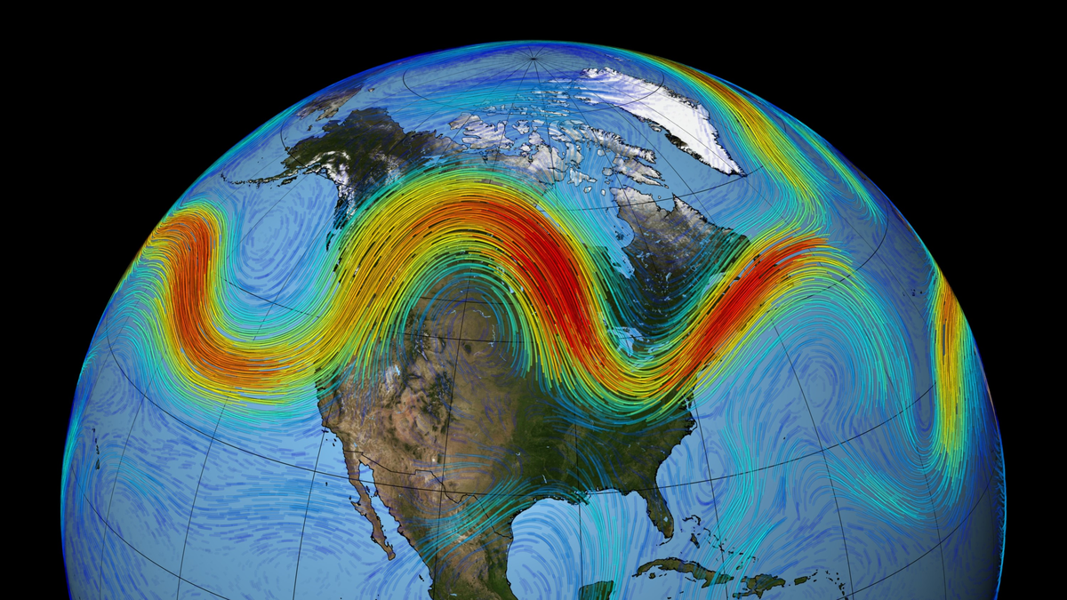
Image credit: NASA/Goddard Space Flight Center Scientific Visualization Studio
A teleconnection is a recurring large-scale circulation pattern that links distant regions through shared atmospheric pressure and temperature changes. The National Oceanic and Atmospheric Administration (NOAA) describes it as a preferred mode of low-frequency variability, an enduring pattern in the jet stream and ocean–atmosphere system that repeats seasonally or over years.
These patterns form because the atmosphere moves heat and energy globally, not locally. When ocean temperatures or convection shift in one area, the resulting change in air pressure can influence other regions thousands of kilometers away.
The Climate Prediction Center (CPC) notes that such patterns often last from several weeks to multiple months, depending on their strength and interaction with seasonal cycles. They are a major reason why global climate models can predict tendencies months in advance.
Teleconnections demonstrate that the climate is not a mosaic of isolated systems. Rather, it behaves as one dynamic network where small changes propagate through the global atmosphere, creating ripple effects that can last for seasons.
From ocean warmth to planetary waves
Teleconnections arise through energy transfer in both the ocean and the atmosphere. When warm or cool anomalies appear at the sea surface, the air above responds, shifting pressure and wind fields. These disturbances propagate as planetary-scale Rossby waves, vast ripples in the jet stream that move energy across the globe.
NOAA’s Physical Sciences Laboratory explains that tropical convection, columns of rising warm, moist air, can launch these waves, altering upper-level winds and changing weather far from the source. The waves travel along the westerlies, connecting the tropics to the mid-latitudes and even to the polar regions.
Ocean–atmosphere coupling intensifies this connection. During an El Niño event, sea-surface temperatures in the central and eastern tropical Pacific rise by 0.5–2°C (0.9–3.6°F), producing stronger convection and heat release. This excites wave trains that extend across the Pacific toward North and South America, reshaping rainfall, temperature, and storm tracks.
These large-scale waves can also influence ocean circulation itself. As they move, they trigger Kelvin and Rossby waves beneath the surface, redistributing heat and sustaining the pattern that caused them in the first place.
The result is a self-reinforcing system: a temperature anomaly in one ocean region can shift atmospheric circulation worldwide, while the altered circulation further modifies ocean currents and temperatures.
ENSO, the engine of global climate links
The El Niño–Southern Oscillation (ENSO) remains the dominant teleconnection on Earth. It oscillates between two opposite phases, El Niño, with warmer-than-average waters in the eastern Pacific, and La Niña, with cooler conditions. Each phase alters atmospheric pressure across the Pacific basin, known as the Southern Oscillation.
During El Niño years, the Walker circulation weakens. This changes rainfall patterns and jet-stream positioning across the globe. In the United States, winters often become wetter across the southern states and milder in the north. In contrast, La Niña typically brings drier southern winters and wetter, colder conditions across the northern plains.
ENSO’s reach extends well beyond the Americas. It can trigger droughts in Indonesia and Australia, enhance rainfall over parts of South America, and influence tropical cyclone activity in both the Pacific and Atlantic Oceans. These impacts depend on the strength and timing of each event.
Because ENSO events recur every 2–7 years, they form the backbone of seasonal climate prediction. The CPC uses ENSO monitoring to issue long-range forecasts, helping farmers, water managers, and emergency planners prepare for likely conditions months in advance.
Although ENSO is powerful, its impacts are probabilistic rather than deterministic. No two events are identical. The specific pattern of warming, the season when it peaks, and interactions with other teleconnections determine how global weather will respond.
Other major teleconnections shaping global weather
While ENSO dominates, several other teleconnections shape the regional climate. The Pacific–North American pattern (PNA) links pressure systems over the North Pacific and North America. Its positive phase typically brings milder, drier conditions to the southern United States and wetter weather to the Pacific Northwest.
The North Atlantic Oscillation (NAO) tracks pressure differences between the Icelandic Low and the Azores High. A positive NAO strengthens westerly winds, delivering mild, stormy winters to northern Europe and the eastern United States. A negative NAO weakens those winds, allowing Arctic cold to spill southward.
Across the Indian Ocean, the Indian Ocean Dipole (IOD) occurs when one side of the basin warms relative to the other. A positive IOD brings heavy rain to East Africa but drought to Indonesia and Australia.
Over longer timescales, the Pacific Decadal Oscillation (PDO) alternates every 20–30 years between warm and cool phases. It influences rainfall and temperature across North America and can amplify or counteract ENSO impacts.
Each pattern interacts with the others. The combination of multiple teleconnections often determines seasonal climate anomalies. For example, a strong El Niño combined with a positive PDO can produce unusually warm winters across western North America.
Forecasting the global web of connections
Teleconnections are essential tools in modern seasonal forecasting. NOAA’s Climate Prediction Center integrates indices such as ENSO, NAO, PNA, and PDO into its long-range outlooks, allowing forecasts to extend several months beyond standard weather timescales.
When ocean surface temperatures begin to shift, meteorologists can project likely effects on rainfall, temperature, and storm activity in other regions. For example, detecting an El Niño early can provide warnings of drought potential in Australia or higher rainfall risks in parts of South America.
These forecasts are expressed as probabilities, not certainties. NOAA emphasizes that teleconnections increase or decrease the likelihood of certain outcomes, but they do not guarantee specific events. The same El Niño strength can yield different responses depending on the season or interactions with other circulation patterns.
Monitoring and analysis rely on data from satellites, ocean buoys, and global climate models. Together, these observations reveal how distant climate systems communicate and evolve. Continuous tracking allows forecasters to refine their understanding and issue updates as new anomalies emerge.
The ultimate goal is preparedness. Recognizing teleconnections helps governments, farmers, and communities anticipate risks, plan resources, and reduce vulnerability to climate variability.
A changing climate, shifting connections
Scientists at NOAA and other agencies are watching for changes in the strength and position of major teleconnections as the planet warms. Warming oceans may alter where tropical convection occurs, shifting Rossby-wave sources and modifying jet-stream responses.
Climate.gov reports that El Niño events may increasingly favor central Pacific warming rather than the eastern pattern typical of past decades. Such a shift could redirect global rainfall and storm tracks in new ways.
The same uncertainty applies to the NAO, IOD, and PDO. Non-stationarity, the tendency for statistical relationships to change over time, makes it difficult to predict whether current linkages will hold in future decades.
Understanding these evolving teleconnections is crucial for improving climate models and long-term risk assessment. Accurate simulation of these global linkages determines how well scientists can forecast regional drought, flood, or temperature extremes under changing background conditions.
By continuously observing the oceans and atmosphere, agencies refine forecasts and update the global picture. Teleconnections remain a core framework for understanding how a single planet-wide climate system distributes heat, energy, and moisture.
Conclusion
Teleconnections knit together the world’s weather. They explain why rainfall in Africa, drought in Australia, and storm tracks over North America can all stem from the same Pacific anomaly.
They are not certainties but shifting probabilities that guide forecasters and planners in managing risk. Their strength lies in showing how local changes connect to global outcomes.
In an interconnected atmosphere, understanding teleconnections is essential for building resilience, improving forecasts, and grasping the true scale of Earth’s dynamic climate system.
References:
1 NOAA Climate Prediction Center – Teleconnection Introduction – Accessed December 10, 2025

I’m a science journalist and researcher at The Watchers, contributing to the Epicenter edition, where I cover peer-reviewed scientific research and emerging discoveries across Earth and space sciences. With a background in astronomy and a passion for environmental science, I’ve worked in shark and coral conservation in Fiji, conducting reef and shark-behavior research, contributing to mangrove restoration, and earning PADI Open Water and Coral Reef Certifications. I bring a blend of scientific rigor and storytelling to illuminate the discoveries shaping our planet and beyond.
Commenting rules and guidelines
We value the thoughts and opinions of our readers and welcome healthy discussions on our website. In order to maintain a respectful and positive community, we ask that all commenters follow these rules.