
Laser-guided drones improve volcanic eruption forecasts
A new drone-based laser system developed by researchers at the Technical University of Munich (TUM), announced on July 10, 2026, could make it safer and more accurate to monitor volcanic gases, one of the most important indicators of impending eruptions. By remotely measuring carbon dioxide without flying sensitive instruments directly through hazardous gas plumes, the approach aims to improve estimates of the carbon dioxide-to-sulfur dioxide (CO2/SO2) ratio, a key parameter volcanologists use to assess changes occurring beneath active volcanoes.
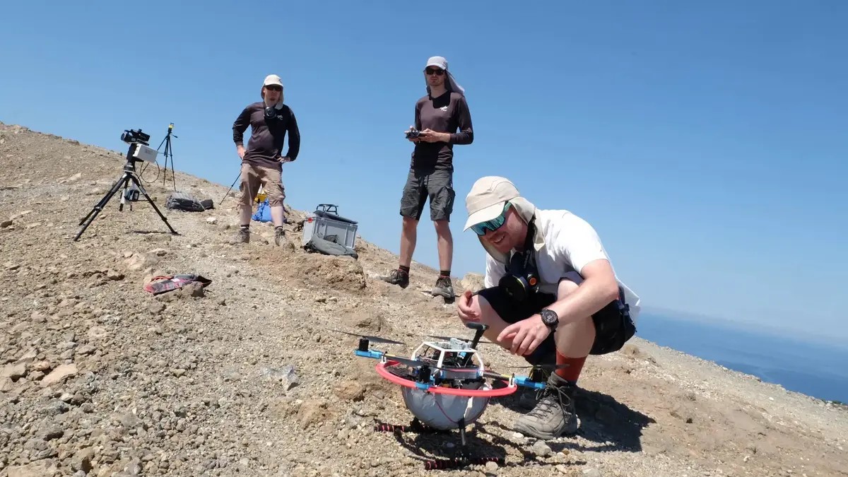
Researcher Marius Schaab (front) from TUM inspects the drone, which is set to fly over volcanic gases in a crater on Vulcano. Credit: Andreas Schmitz/TUM
Scientists have long known that rising magma releases increasing amounts of carbon dioxide before sulfur dioxide becomes dominant. Tracking changes in the CO2/SO2 ratio therefore provides valuable clues about magma movement and the likelihood of an eruption. Obtaining those measurements, however, has remained difficult because instruments carried by drones are disturbed by the powerful airflow generated by their own propellers, introducing significant uncertainty into the data.
Researchers at TUM have now demonstrated an alternative approach that keeps the laser instrument safely on the ground while sending only a lightweight spherical reflector beneath a drone. Using Tunable Diode Laser Absorption Spectroscopy (TDLAS), the laser beam passes through the volcanic plume, reflects from the airborne target and returns to the ground instrument, allowing scientists to calculate carbon dioxide concentrations without placing the sensor inside the disturbed airflow created by the aircraft.
“The advantage of our method is that the laser measuring device remains on the ground. The drone only carries a lightweight reflector,” said Prof. Achim Lilienthal, Professor of Perception for Intelligent Systems at TUM. “This allows us to take measurements safely from a greater distance while avoiding interference from the drone’s propellers.”
The system was recently deployed autonomously on the volcanic island of Vulcano in Italy’s Aeolian Islands, marking an important milestone in the project’s development. According to TUM, the autonomous platform can collect around 3 000 individual measurements within 10 to 15 minutes, producing dense datasets that would be difficult to obtain using conventional field techniques.
Earlier wind tunnel experiments demonstrated that the measurement concept can achieve an error margin of approximately 5%, providing quantitative evidence that the remote sensing approach is capable of delivering highly accurate gas concentration measurements under controlled conditions.
The technology builds on research published by Marius Schaab and colleagues, who evaluated the concept at the Salinelle dei Cappuccini mud volcanoes near Mount Etna, Sicily. Rather than measuring gases directly inside the plume, the team reconstructed carbon dioxide distributions using gas tomography, combining multiple laser measurements from different viewing angles.
One of the main challenges was compensating for the movement of volcanic gases after they left the vent. Instead of assuming the plume remained stationary, the researchers incorporated a Lagrangian transport model that estimates how far the gas drifts before reaching the laser measurement plane. In their field experiments, the reconstruction accounted for an approximately three-second transport delay between emission and measurement, significantly improving agreement with ground observations.
The researchers compared three different approaches during the field campaign: handheld in-situ carbon dioxide measurements, drone-mounted in-situ sensors and the new open-path laser tomography system. The laser-based reconstructions closely matched handheld measurements while avoiding the systematic underestimation observed when sensors were mounted directly beneath the drone, where rotor downwash diluted the sampled gas.
The study also illustrates two complementary strategies being pursued by the research partners. While TUM is advancing remote laser-based measurements that keep sensors on the ground, researchers at Johannes Gutenberg University Mainz continue developing drone platforms that fly directly into volcanic plumes using onboard gas sensors. Together, the approaches aim to expand the range of tools available for monitoring volcanic activity under different field conditions.
“The carbon dioxide-to-sulfur dioxide ratio tells us how deep the magma currently is,” explained Prof. Thorsten Hoffmann of Johannes Gutenberg University Mainz. “Carbon dioxide is released under higher pressure and therefore at greater depth than sulfur dioxide.”
Prof. Nicole Bobrowski, also from Johannes Gutenberg University Mainz, said changes in gas composition can provide valuable information about volcanic unrest.
“Different volcanic gases escape from magma at different depths. By observing changes in gas ratios over time, we can recognize characteristic signatures that may indicate rising magma before an eruption.”
The researchers believe the combination of autonomous drones, remote laser sensing and advanced atmospheric reconstruction could eventually make volcanic gas monitoring both safer and more frequent, particularly at hazardous or difficult-to-access volcanoes. Looking ahead, Lilienthal said the team’s long-term objective is to incorporate artificial intelligence capable of automatically interpreting the large volumes of gas measurements collected during drone surveys, helping scientists identify patterns associated with volcanic unrest more efficiently.
References:
1 Better prediction of volcanic eruptions – TUM – July 10, 2026
2 Schaab, M., Kokot, M., Bobrowski, N., Hoffmann, T., Kern, C., Lilienthal, A. J., & Stachniss, C. (2025). Towards drone-based mapping of volcanic gases using gas tomography. arXiv. https://doi.org/10.48550/arXiv.2605.27180

I’m a science journalist and researcher at The Watchers, contributing to the Epicenter edition, where I cover peer-reviewed scientific research and emerging discoveries across Earth and space sciences. With a background in astronomy and a passion for environmental science, I’ve worked in shark and coral conservation in Fiji, conducting reef and shark-behavior research, contributing to mangrove restoration, and earning PADI Open Water and Coral Reef Certifications. I bring a blend of scientific rigor and storytelling to illuminate the discoveries shaping our planet and beyond.
Published in the last 24 hours
- A fireball over northern China on 6 November 2026 punched a crater into a wheat field at Beigucheng village in Hebei; the Institute of Geochemistry has now classified the fallen stones as L6 ordinary chondrites. Epicenter
- Weather radar tracked meteorites falling into Cape Cod Bay after a 1.1-kiloton fireball over Massachusetts on 30 May 2026; researchers have now traced its orbit almost out to Jupiter. Epicenter
- 10 named storms, one hurricane for the first time since 1925: Why has the Atlantic been so quiet in 2026 Epicenter
- Bay of Bengal system to become Cyclone Akvan, landfall forecast between Nellore and Tuni on November 20, India
