
SPC forecasts supercells and damaging wind clusters across Iowa late May 15
The Storm Prediction Center (SPC) placed Iowa under an Enhanced Risk for severe thunderstorms late May 15, 2026, with severe/damaging winds and large to very large hail forecast late this afternoon and evening. Initial supercells may produce hail of 5 cm (2 inches) or larger before storms organize into clusters capable of localized wind gusts above 120 km/h (75 mph).
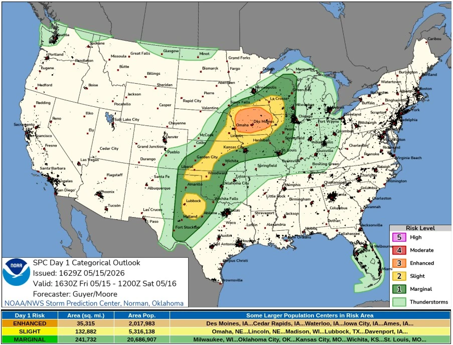
SPC Convective Outlook for May 15, 2026. Credit: NWS/SPC
Severe thunderstorms capable of damaging winds and large to very large hail are forecast late this afternoon and evening, centered across much of Iowa. Isolated to scattered severe hail and damaging winds are also possible over a broader area from parts of the southern High Plains to the Upper Midwest.
Storm development is forecast along the cold front and surface trough from eastern Nebraska into Iowa around 17:00–19:00 CDT (22:00–00:00 UTC). Large-scale ascent will remain weak until a low-amplitude shortwave trough embedded in the westerly mid-level flow moves over the surface warm sector.
Instability is forecast to reach 2 500+ J/kg MLCAPE across the region by early evening, with 65–95 km/h (40–60 mph) deep-layer shear supporting organized updrafts. Low-level winds are forecast to remain fairly modest, while stronger mid- and upper-level flow supports organized storm development.
About 91 500 km2 (35 315 mi2) and 2.02 million people are included in the Enhanced Risk area, covering larger population centers such as Des Moines, Cedar Rapids, Waterloo, Iowa City, and Ames, Iowa.
The surrounding Slight Risk covers about 344 200 km2 (132 880 mi2) and 5.32 million people, including Omaha and Lincoln, Nebraska, Madison, Wisconsin, Lubbock, Texas, and Davenport, Iowa.
Initial supercells are forecast to carry a threat for large to isolated very large hail of 5 cm (2 inches) or larger. A quick upscale growth is expected across Iowa during the evening, increasing the potential for scattered severe/damaging winds, localized gusts above 120 km/h (75 mph), and a tornado or two as low-level shear increases with a strengthening low-level jet.
Across the southern High Plains, SPC forecast high-based thunderstorms near and south of a secondary surface low over southwest Kansas and northwest Oklahoma.
A more probable zone for thunderstorm-related gust potential may focus across the Texas South Plains and Low Rolling Plains, where isolated gusts above 115 km/h (70 mph) may occur in a deeply mixed boundary layer extending to around 500 hPa.
References:
1 Day 1 Convective Outlook – NWS/SPC – May 15, 2026
I'm a dedicated researcher, journalist, and editor at The Watchers. With over 20 years of experience in the media industry, I specialize in hard science news, focusing on extreme weather, seismic and volcanic activity, space weather, and astronomy, including near-Earth objects and planetary defense strategies. You can reach me at teo /at/ watchers.news.
Commenting rules and guidelines
We value the thoughts and opinions of our readers and welcome healthy discussions on our website. In order to maintain a respectful and positive community, we ask that all commenters follow these rules.