
Red Flag Warnings in effect as dry thunderstorms threaten new fire starts across the Plains
Dry lightning, severe outflow winds, single-digit to teen relative humidity, and receptive fuels created Critical fire weather conditions across parts of the Plains and southern High Plains on May 15, 2026.

Image credit: U.S. Wildland Fire Service
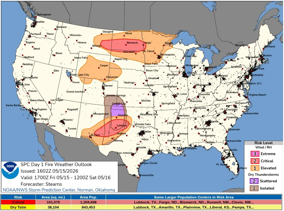
The Storm Prediction Center (SPC) placed about 261 780 km2 (101 075 mi2) and 1 269 700 people under Critical fire weather risk on May 15. The dry thunderstorm area covers about 98 670 km2 (38 100 mi2), including Lubbock, Amarillo, Plainview, Liberal, and Pampa.
The Day 1 outlook carries three Critical fire weather areas — scattered dry thunderstorms over portions of the southern High Plains, dry and windy conditions over portions of the southern High Plains, and dry and windy conditions over portions of the Northern Plains. SPC described a “widespread and multi-faceted threat” across portions of the Plains, with dry thunderstorm coverage extended northward across parts of southeastern Colorado.
Dry and windy conditions were already in place over the Texas Panhandle and nearby areas by late morning, with relative humidity in the single digits to teens and southwest winds near 15–30 km/h (10–20 mph). As high-based storms developed later in the day, the same dry boundary layer was forecast to support localized very strong outflow gusts over parts of the Texas Panhandle after 18:00 CDT (23:00 UTC).
Across the southern High Plains, a deep, dry boundary layer west of a diffuse dryline was forecast to overlap sustained westerly winds of at least 25 km/h (15 mph) and 10–15% relative humidity from southern New Mexico to the Texas Panhandle and Oklahoma border.
Critical fire weather extended from southeastern New Mexico into the Texas Rolling Plains, where sustained southwesterly winds of at least 40 km/h (25 mph) were forecast to coincide with RH below 15% for several hours.
The dry thunderstorm risk added an ignition mechanism to the wind-driven spread environment. SPC said seasonably cold mid-level temperatures over a boundary layer extending up to 500 hPa would support high-based storms with thin CAPE up to 500 J/kg, initially near the New Mexico and Texas Panhandle border by mid-afternoon.
Strong flow aloft was forecast to move storms quickly eastward, with erratic gusts and isolated lightning-induced ignitions possible near the onset of storm development.
The greater dry-lightning concern was forecast farther east into the Oklahoma Panhandle and Texas Rolling Plains, where storm coverage and intensity were expected to increase over drier fuels with above-average fuel loading. Erratic to severe wind gusts of at least 95 km/h (58 mph), broader gradient winds, scant rainfall, and lightning could support several ignitions followed by rapid spread.
NWS Lubbock keeps a Red Flag Warning in effect for the South Plains, Rolling Plains, and southern Texas Panhandle until 21:00 CDT on May 15 (02:00 UTC on May 16), and a Fire Weather Watch to 22:00 CDT on May 16. The warning area includes Parmer, Castro, Swisher, Briscoe, Hall, Childress, Bailey, Lamb, Hale, Floyd, Motley, Cottle, Cochran, Hockley, Lubbock, Crosby, Dickens, Yoakum, Terry, Lynn, Garza, and Kent counties.
In the Lubbock warning area, forecast conditions included Friday southwest winds of 25–40 km/h (15–25 mph), Saturday southwest winds of 30–50 km/h (20–30 mph), humidity as low as 7%, and critically dry fuels. NWS Lubbock said any fires that develop can spread rapidly, while storms across portions of the Caprock and Rolling Plains were capable of producing severe wind gusts up to 115 km/h (70 mph).
NWS Norman maintains a Red Flag Warning for western Oklahoma and western North Texas until 21:00 CDT on May 15. The office warned of south winds of 25–40 km/h (15–25 mph), gusts up to 65 km/h (40 mph), RH as low as 10%, temperatures up to 40.6°C (105°F), ERC fuels in the 70th–89th percentile, and a fire environment rating of 7 out of 10.
In western and central North Dakota, including the James River Valley, NWS Bismarck keeps a Red Flag Warning in effect through 21:00 CDT on May 15. The warning calls for west winds of 40–55 km/h (25–35 mph), gusts up to 80 km/h (50 mph), RH as low as 15%, and rapid fire spread with difficult control for any fires that ignite.
NWS Albuquerque said windy and dry conditions would continue across the East Central Plains into the early evening of May 15, with winds expected to restrengthen across a more widespread part of northern and central New Mexico on May 16.
A Red Flag Warning for the Northeast Plains and Northeast Highlands was issued from 14:00 to 20:00 MDT on May 16, with south winds of 25–40 km/h (15–25 mph), gusts up to 55 km/h (35 mph), RH of 6–9%, and rapid spread risk for any fires that develop.
The National Interagency Fire Center (NIFC) 07:30 MDT Incident Management Situation Report placed the country at National Preparedness Level 2 and described light initial attack activity, with 118 fires, 6 new large incidents, 16 uncontained large fires, and 1 992 personnel assigned nationally. The Southwest Area had 7 new fires, 1 new large incident, and 4 uncontained large fires, while the Rocky Mountain Area had 13 new fires, 3 new large incidents, and 3 uncontained large fires.
The Hunggate Fire was burning in grass and brush on private land about 3 km (2 miles) southwest of Canyon, Texas, according to NIFC’s situation report. The Texas A&M Forest Service incident showed active fire behavior, including wind-driven runs, creeping, and long-range spotting, with the fire area reported at 5 666 ha (14 000 acres), 10% containment, 2 structures lost, and an estimated containment date of May 18.
Other active incidents in fire weather-relevant regions included the Seven Cabins Fire, 21 km (13 miles) northwest of Capitan, New Mexico, where NIFC reported wind-driven runs, short-range spotting, and threats to structures and communication infrastructure.
In Nebraska, the Ash Pole Fire southeast of Crawford was at 445 ha (1 100 acres) and 0% contained, with residences threatened, while the Rochelle 2 Fire in Wyoming was at 607 ha (1 500 acres) and 0% contained, also with structures threatened.
References:
1 Day 1 Fire Weather Outlook – NWS/SPC – May 15, 2026
2 Incident Management Situation Report – NIFC – May 15, 2026
3 Red Flag Warning summary – NWS – May 15, 2026
I'm a dedicated researcher, journalist, and editor at The Watchers. With over 20 years of experience in the media industry, I specialize in hard science news, focusing on extreme weather, seismic and volcanic activity, space weather, and astronomy, including near-Earth objects and planetary defense strategies. You can reach me at teo /at/ watchers.news.
Commenting rules and guidelines
We value the thoughts and opinions of our readers and welcome healthy discussions on our website. In order to maintain a respectful and positive community, we ask that all commenters follow these rules.