
Multi-state Red Flag Warnings issued as strong winds and very low humidity raise wildfire danger across the central U.S.
Red Flag Warnings are in effect across a broad swath of the Plains, Rockies, and parts of the Upper Midwest on Wednesday, April 22, 2026, as strong winds, very low relative humidity, and dry fuels create critical fire weather conditions. The National Weather Service warns that any fires that start could spread quickly and be hard to control. In some areas, isolated dry thunderstorms may produce lightning with little or no rain, increasing the risk of new fires.
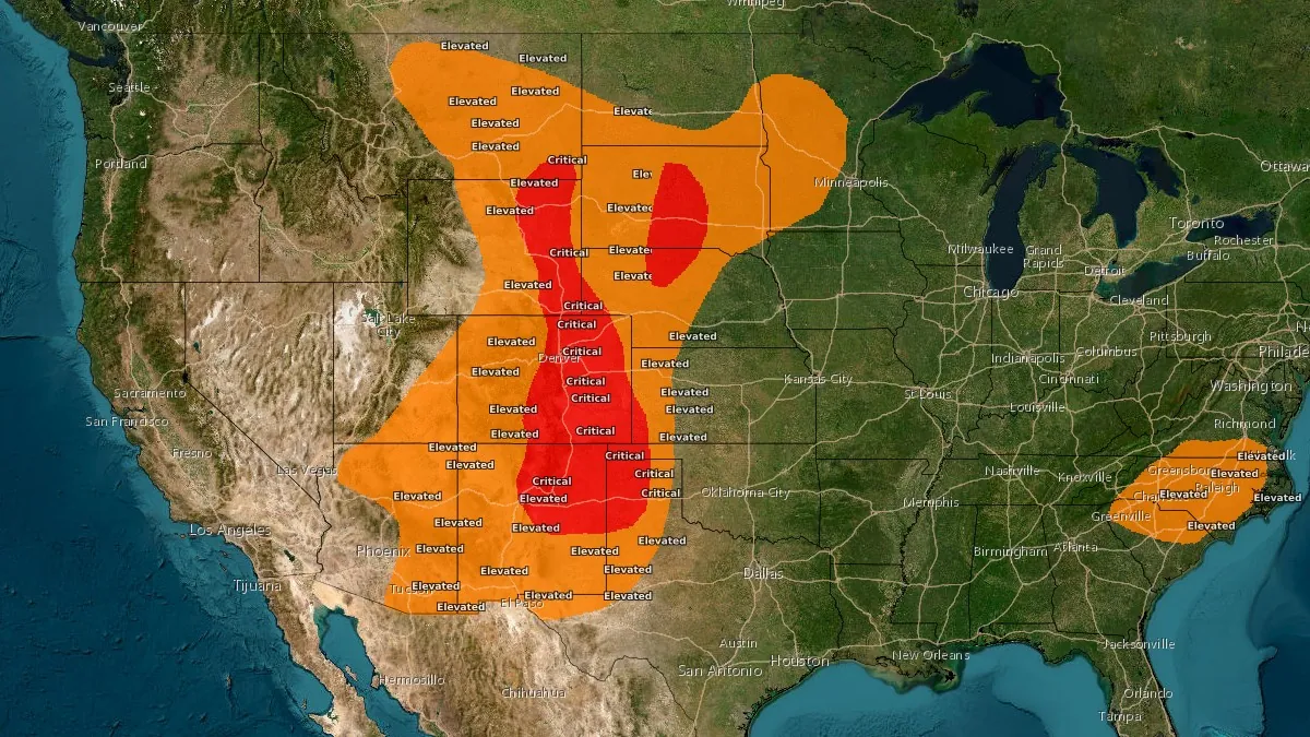
Day 1 Fire Weather Outlook showing Critical fire weather areas on April 22, 2026. Credit: NWS/SPC
A sweeping fire weather setup extended from the Desert Southwest into the northern Great Plains on Wednesday, April 22, with the Storm Prediction Center (SPC) designating Critical fire weather conditions across a broad corridor and National Weather Service offices issuing Red Flag Warnings across more than a dozen states.
The SPC’s Day 1 Fire Weather Outlook placed Critical fire weather areas from east-central New Mexico into the northern High Plains and from north-central Nebraska into central South Dakota, with widespread Red Flag Warnings issued as strong winds, very low relative humidity, and dry fuels combined to support rapid fire spread.
The highest-level designation came from the NWS office in Pueblo, which issued a Particularly Dangerous Situation Red Flag Warning, a threshold reserved for extreme fire weather conditions, for fire weather zones 224 and 225 in south-central and southeastern Colorado.
This area is forecast to experience southwest to west-southwest winds of 40-64 km/h (25-40 mph), with gusts up to 97 km/h (60 mph), and relative humidity as low as 6-8 percent. The office warned that fires could spread uncontrollably, become highly destructive, and outpace evacuation in some scenarios.
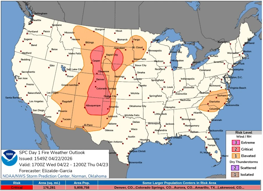
Farther north along the Front Range and adjacent plains, the NWS office in Denver/Boulder issued a Red Flag Warning from 10:00 MDT to midnight MDT covering the foothills, urban corridor, plains, and South Park. Winds were forecast at 32-48 km/h (20-30 mph), with gusts up to 72 km/h (45 mph), while relative humidity dropped to 5-8 percent. A Fire Weather Watch remains in effect for Thursday, April 23.
Red Flag Warnings are also in effect across central and north-central Wyoming, parts of Arizona, large sections of Nebraska and South Dakota, western and south-central North Dakota, southwest Kansas, the Oklahoma and Texas Panhandles, portions of Minnesota and Wisconsin, and parts of eastern Montana. Relative humidity ranges from 5 to 15 percent, with sustained winds up to 50 km/h (30 mph) and gusts up to 90 km/h (55 mph) — supporting rapid ignition and spread potential.
In Goodland, Kansas, forecasters warned of south winds up to 50 km/h (30 mph), with gusts up to 70 km/h (45 mph), and relative humidity as low as 10 percent across parts of northwest Kansas, southwest Nebraska, and eastern Colorado.
In Riverton, Wyoming, southwest winds up to 65 km/h (40 mph), with gusts up to 90 km/h (55 mph) and occasional higher gusts, combined with humidity values of 10-13 percent. In Rapid City, South Dakota, relative humidity dropped to around 9 percent.
NWS bulletins from parts of Kansas and Nebraska, along with the broader SPC outlook, show isolated dry thunderstorms capable of producing lightning with minimal precipitation. This setup supports ignition without wetting rainfall, while convective outflows introduce erratic wind shifts that can accelerate fire spread.
The pattern aligns with late-April seasonality across the central United States, where strengthening spring systems intersect with dormant fuels. Downslope flow east of the Rockies, deep boundary-layer mixing, and a tightening pressure gradient beneath the upper trough enhanced drying and wind fields across the region.
Forecast guidance suggests the fire-weather threat will persist into Thursday, April 23, shifting toward the southern High Plains.
The Weather Prediction Center maintains elevated fire risk as the system progresses eastward, while local offices in Colorado and New Mexico have issued additional Fire Weather Watches and Red Flag Warnings for April 23. Repeated low-humidity and high-wind periods sustain elevated ignition and rapid spread potential even in the absence of confirmed large wildfire activity.
References:
1 Short Range Forecast Discussion – NWS/WPC – April 22, 2026
2 Day 1 Fire Weather Outlook – NWS/SPC – April 22, 2026
I'm a dedicated researcher, journalist, and editor at The Watchers. With over 20 years of experience in the media industry, I specialize in hard science news, focusing on extreme weather, seismic and volcanic activity, space weather, and astronomy, including near-Earth objects and planetary defense strategies. You can reach me at teo /at/ watchers.news.
Commenting rules and guidelines
We value the thoughts and opinions of our readers and welcome healthy discussions on our website. In order to maintain a respectful and positive community, we ask that all commenters follow these rules.