
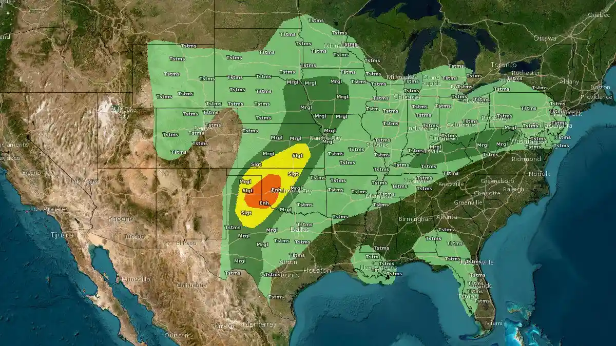
SPC issues Enhanced Risk for severe storms with large hail and tornado potential across Texas-Oklahoma-Kansas
Severe thunderstorms capable of producing very large hail, damaging winds, and a few tornadoes are forecast to develop across the Texas Panhandle, western Oklahoma, and southern Kansas late on March 5, 2026. The National Weather Service Storm Prediction Center (SPC) has issued an Enhanced Risk as a dryline and strengthening upper-level trough create favorable conditions for supercell development during the late afternoon and evening.
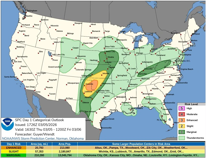
Categorical Outlook for March 5, 2026. Image credit: NWS
Severe thunderstorms are forecast to develop across parts of the southern and central Plains of the United States on March 5 as an amplified upper-level pattern develops across the country.
Forecast discussions from the National Weather Service (NWS) indicate that troughing over the Rocky Mountains and ridging across the eastern United States will support severe thunderstorms and locally heavy rainfall from western Texas into southern Kansas.
Showers and thunderstorms were already ongoing early Thursday morning near the Red River of the South, extending into parts of the Ohio Valley. These storms are expected to weaken through the afternoon, but new thunderstorm development is forecast later in the day ahead of a dryline across Texas and Oklahoma.
The Storm Prediction Center has placed parts of the eastern Texas Panhandle and western Oklahoma under an Enhanced Risk of severe thunderstorms. Scattered severe storms are forecast to develop late in the afternoon and evening from northwest Texas and the Texas Panhandle into western Oklahoma and southern to central Kansas.
An upper-level trough amplifying across the western United States will support broad southwesterly flow across the Plains. At the surface, lee cyclogenesis is forecast to occur across eastern Colorado during the day, strengthening low-level southerly flow and transporting moisture northward from the Gulf of Mexico into Texas, Oklahoma, and Kansas.
Daytime heating and steep mid-level lapse rates are expected to generate moderate atmospheric instability across the region. Forecast soundings indicate mixed-layer convective available potential energy reaching approximately 1 000–1 500 J/kg by late afternoon along and east of the dryline. Most model guidance indicates convective temperatures will be reached between 21:00–23:00 UTC, allowing thunderstorms to initiate across the southern High Plains.
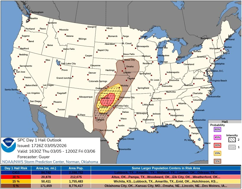
Deep-layer wind shear near 40 kt will support the development of organized supercell thunderstorms. Discrete storms forming along the dryline may initially produce large to very large hail, potentially reaching diameters of 5–7.5 cm (2–3 inches).
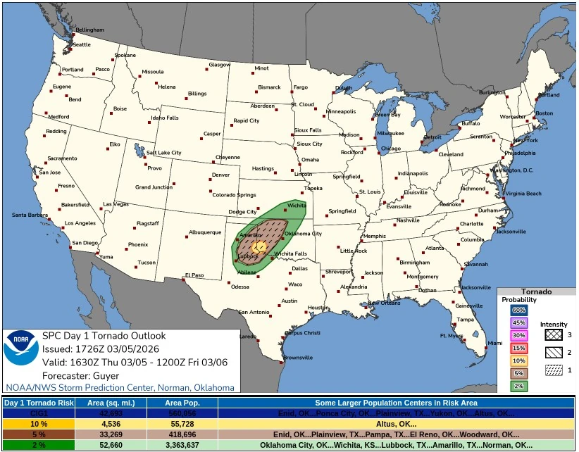
Increasing low-level wind shear during the evening is expected to enlarge low-level hodographs, creating an environment supportive of tornado development with some storms. Forecasters indicate that a few tornadoes will be possible, particularly with storms that remain discrete during the early stages of convective development.
Storms are forecast to gradually organize into a small but potentially intense convective cluster during the evening as activity spreads northeastward into western and northern Oklahoma and southern to central Kansas overnight.
Isolated severe storms may also develop farther south along the dryline across western Texas, although storm coverage in that region may remain limited due to weaker large-scale forcing.
Farther north, isolated severe hail may occur overnight across eastern Nebraska, northwest Missouri, and parts of Iowa as elevated convection develops amid warm-air advection.
A separate area of storms may develop across the Ohio Valley and central Appalachians during the day as a mid-level shortwave trough moves eastward through the region. Although atmospheric instability is expected to remain modest, strong winds aloft may allow loosely organized storm clusters to produce occasional damaging wind gusts.
Scattered convection may develop along the western Florida Peninsula during the afternoon, where low-level convergence will be maximized. Strong surface heating combined with dewpoints dropping to approximately 18–20°C (64–68°F) may support thunderstorms in the region, although weak deep-layer wind shear is expected to limit organized severe storm development.
The severe weather threat is expected to expand eastward on March 6 as a warm front lifts north across the central United States. The Storm Prediction Center Day 2 outlook indicates Slight and Enhanced Risk areas from parts of the southern and central Plains into portions of the Midwest.
In addition to the severe weather threat, other hazardous weather conditions are forecast across the United States during the same period.
Gusty winds and low relative humidity are expected to create favorable conditions for wildfire development across eastern New Mexico on March 5, with the threat expanding into portions of western Texas on March 6.
On the colder side of the frontal boundary, snow will advance from interior portions of the Pacific Northwest into the northern and central Rocky Mountains. Higher elevations may receive 15–30 cm (6–12 inches) of snow, with locally higher totals exceeding 30 cm (12 inches) possible through March 6.
A separate winter weather event is expected across parts of the northeastern United States late on March 5 into early March 6. New England will remain north of a stationary front positioned across the Mid-Atlantic coast while a secondary cold frontal surge moves through the region.
Low-pressure tracking south of New England will allow a wintry mix of snow, sleet, and freezing rain to develop across portions of central New England late Thursday evening into early Friday morning. Freezing rain is expected to be the dominant hazard across higher terrain from interior New York into Massachusetts, where ice accumulations of approximately 2.5–6.4 mm (0.10–0.25 inches), locally higher, may occur.
Precipitation is forecast to end by midday Friday across the Northeast, although temperatures are expected to remain below average with highs remaining in the 0–4°C (30–39°F) range across many parts of New England.
Temperatures across much of the central and eastern United States will remain well above average during the same period as a warm front lifts north across the middle of the country. Locations from Nebraska and South Dakota into much of the Ohio Valley may experience daytime temperatures approximately 11–17°C (20–30°F) above seasonal averages.
References:
1 Short Range Public Discussion – NWS – March 5, 2026
2 Day 1 Convective Outlook – NWS – March 5, 2026

I’m a science journalist and researcher at The Watchers, contributing to the Epicenter edition, where I cover peer-reviewed scientific research and emerging discoveries across Earth and space sciences. With a background in astronomy and a passion for environmental science, I’ve worked in shark and coral conservation in Fiji, conducting reef and shark-behavior research, contributing to mangrove restoration, and earning PADI Open Water and Coral Reef Certifications. I bring a blend of scientific rigor and storytelling to illuminate the discoveries shaping our planet and beyond.
Commenting rules and guidelines
We value the thoughts and opinions of our readers and welcome healthy discussions on our website. In order to maintain a respectful and positive community, we ask that all commenters follow these rules.