
Multi-hazard winter storm brings snow, freezing rain, and tornado risk from Great Plains to East Coast, U.S.
A winter storm system developing over the central United States on February 19, 2026, is expected to produce snow and ice from the Northern Plains to the Northeast, while also supporting tornado and large hail potential in the Midwest.
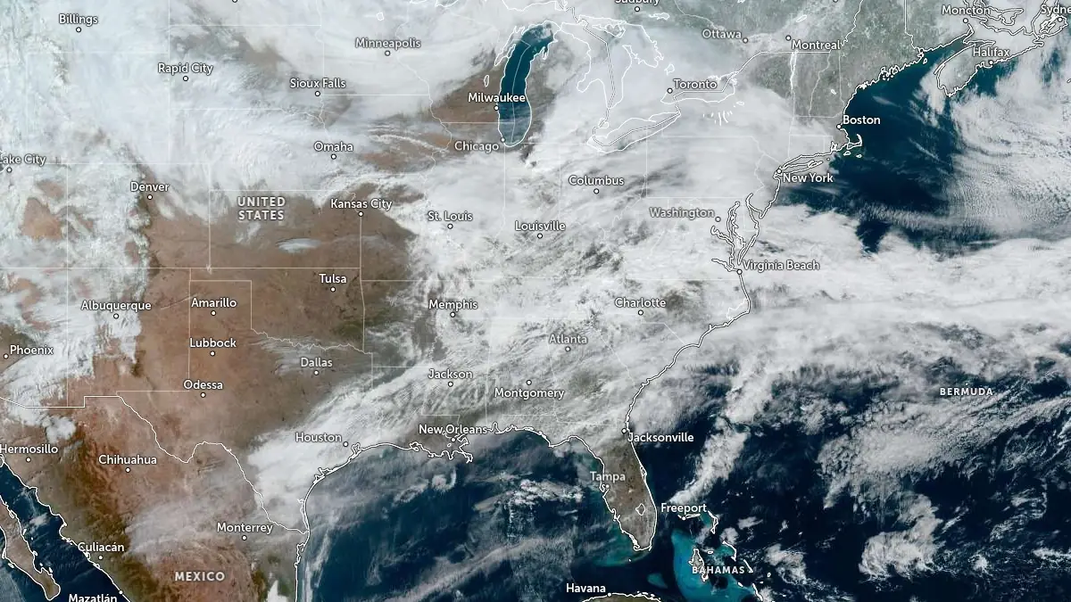
Image credit: NOAA/GOES-East, Zoom Earth, The Watchers. Acquired at 16:10 UTC on February 19, 2026
A deep mid-latitude cyclone is organizing over the Great Plains on February 19, generating a broad multi-hazard event across much of the continental United States.
The system is forecast to track northeastward into the Upper Midwest and Great Lakes through February 20, then advance into the Northeast, producing winter weather, severe thunderstorms, fire weather concerns, and sharp temperature contrasts.
Snow is spreading across portions of Nebraska and Iowa during the day on February 19, with several inches expected. The Central Plains and the Midwest may see locally heavy snowfall of 102–203 mm (4–8 inches) on Thursday and 152–305 mm (6–12 inches) across northern Michigan and Wisconsin by Friday.
The storm will enter the Northeast from Friday into Saturday and bring a swath of 102–203 mm (4–8 inches) of snowfall into Upstate New York and New England. Freezing rain could produce ice accumulations of 0.3–6.4 mm (0.01–0.25 inches) across the northern Mid-Atlantic and New York.
As the system strengthens and shifts northeastward tonight, light snow and areas of freezing rain are forecast across parts of the Upper Great Lakes. Mixed precipitation, including sleet and freezing rain, will expand into the interior Northeast and southern New England on February 20. Impacts from ice accretion and snowfall are expected to be generally minor but may cause localized travel disruptions.
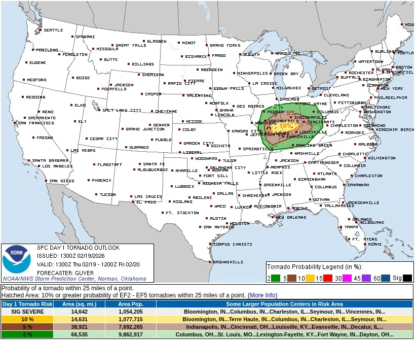
Ahead of the cold front, scattered rain showers and thunderstorms are forecast to develop across the Middle Mississippi Valley into the lower Ohio Valley during the afternoon and evening hours of February 19.
According to the National Weather Service (NWS), environmental conditions may support a couple of tornadoes, large hail, and damaging wind gusts. The severe weather threat is forecast to shift into portions of the central Gulf Coast states on February 20, where isolated severe hail and localized strong wind gusts remain possible.
The strengthening surface low is forecast to deepen as it moves into the Upper Midwest and Great Lakes on February 20, maintaining a corridor of snow and mixed precipitation north and west of the low track. Rain showers are also expected to spread into the Mid-Atlantic.
Temperatures ahead of the storm system remain well above average across much of the eastern half of the country through February 20. High temperatures in parts of the Midwest are forecast to reach 16–26°C (60– 79°F), approximately 11–17°C (52–62°F) above average.
Widespread maximum and minimum temperature records may be tied or broken across portions of the Southeast. In contrast, troughing over the western United States is maintaining below-average temperatures, with cooler air forecast to gradually expand eastward into the weekend.
References:
1 NWS short-range forecast – NWS – February 19, 2026

I am an Assistant Editor and Severe Weather & Science Journalist at The Watchers, specializing in real-time severe weather coverage, geophysical event reporting, and research-driven scientific analysis. You can reach me at rishav(at)watchers(.)news.
Commenting rules and guidelines
We value the thoughts and opinions of our readers and welcome healthy discussions on our website. In order to maintain a respectful and positive community, we ask that all commenters follow these rules.