
Rapid overnight growth pushes Ranger Road Fire across Oklahoma–Kansas border, 4 firefighters injured
A fast-moving Ranger Road Fire ignited on February 17, 2026, in Beaver County, Oklahoma, and expanded into southern Kansas by February 18, burning approximately 58 700 ha (145 000 acres) within hours. The wildfire prompted mandatory evacuations in Clark County, Kansas, and injured at least four firefighters during suppression efforts.

Ranger Road Fire as seen from Ashland, KS on February 17, 2026. Credit: Kansas Mesonet
The Ranger Road Fire ignited in Beaver County in the Oklahoma Panhandle on February 17, and rapidly expanded northward into southern Kansas. As of February 18, the fire had burned approximately 58 700 ha (145 000 acres) across parts of Oklahoma and Kansas, with 0% containment reported by state forestry officials.
Strong winds reaching 105 km/h (65 mph) combined with dry surface fuels to support rapid rates of spread across grassland areas. Fire behavior under such conditions limited early suppression efforts and allowed the fire perimeter to expand quickly across the Oklahoma–Kansas border.
Mandatory evacuation orders were issued for the Kansas communities of Ashland and Englewood in Clark County as the fire advanced toward populated areas. Earlier evacuation notices were issued in parts of Beaver County, Oklahoma.
Emergency shelters were opened farther east to accommodate displaced residents.
According to state authorities, at least four firefighters were injured during response operations. Three were hurt when a fire vehicle overturned under hazardous conditions, and another required hospitalization after exposure to fire conditions. No confirmed fatalities had been reported as of 14:43 UTC on February 18.
Road closures were implemented along portions of US-64 and state highways near Forgan, Oklahoma, and toward the Kansas state line due to fire activity and reduced visibility from smoke. Some routes reopened as conditions shifted, though officials continued to advise residents to monitor local alerts.
The cause of the fire remains under investigation, and no official ignition source has been confirmed.
February is not climatologically the peak wildfire period for the central High Plains. However, late-winter grassland fires can occur when strong pressure gradients coincide with low humidity and dormant fine fuels. Such conditions can produce rapid perimeter growth despite cooler seasonal temperatures.
Critical fire weather conditions persist across parts of the southern Plains on February 18, complicating containment efforts and sustaining elevated wildfire risk in the region.
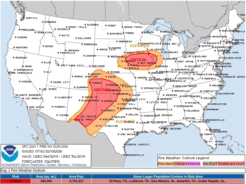
The National Weather Service’s Storm Prediction Center (SPC) designated much of the southern High Plains under Critical fire weather conditions today, citing the combined influence of strengthening mid-level disturbances and a tightening surface pressure gradient.
The Storm Prediction Center’s Critical fire weather area covers approximately 503 000 km2 (194 305 mi2) and includes a population of about 5 731 417 people. Larger population centers within the designated risk area include El Paso, TX, Lubbock, TX, Amarillo, TX, Des Moines, IA, and Cedar Rapids, IA, all located within regions forecast to experience overlapping low relative humidity and strong winds supportive of rapid wildfire spread.
Forecasters indicated that a mid-level trough ejecting into the southern Plains would enhance downslope flow east of the southern Rockies, supporting sustained westerly surface winds near 40 km/h (25 mph), with higher gusts. The winds are forecast to overlap with relative humidity values of 10–15% across northeastern New Mexico, the Texas Panhandle, and adjacent areas.
The environment was classified as high-end Critical, with localized Extremely Critical pockets possible where fuels are most receptive.
Broader portions of the southern High Plains were forecast to experience sustained west-southwesterly winds of 25–35 km/h (15–20 mph) coinciding with relative humidity values of 15–20% for several hours, supporting Elevated to Critical fire weather conditions.
Critical conditions are extending into parts of the Midwest, including central Iowa and surrounding areas, where sustained westerly winds near 40 km/h (25 mph) were forecast to overlap with relative humidity values of 15–25%.
References:
1 Wildfire Situation Update 1 – OEM – February 17, 2026
2 Day 1 Fire Weather Outlook – NWS/SPC – February 18, 2026
I'm a dedicated researcher, journalist, and editor at The Watchers. With over 20 years of experience in the media industry, I specialize in hard science news, focusing on extreme weather, seismic and volcanic activity, space weather, and astronomy, including near-Earth objects and planetary defense strategies. You can reach me at teo /at/ watchers.news.
Commenting rules and guidelines
We value the thoughts and opinions of our readers and welcome healthy discussions on our website. In order to maintain a respectful and positive community, we ask that all commenters follow these rules.