
Rare High Risk (4/4) for excessive rainfall issued for Southern California
The NWS Weather Prediction Center has issued a rare High Risk (level 4/4) for excessive rainfall across Southern California from Wednesday, December 24, through the morning of Thursday, December 25, 2025.

Satellite image acquired at 00:00 UTC on December 23, 2025. Credit: NOAA/GOES-East, Zoom Earth, The Watchers
- The potential for high hourly rainfall totals will intensify runoff over soils that are relatively dry or within recent burn-scar areas, greatly increasing the risk of flash flooding.
- This environment is expected to produce landslides, rock falls, and mudslides across vulnerable terrain.
- The greater-than-normal travel anticipated during the Christmas holiday will likely expose a larger number of people to these life-threatening hazards, a factor taken into consideration by forecasters when upgrading the event to a High Risk.
A strong atmospheric river is forecast to impact Southern California beginning late Tuesday and continuing through Thursday morning, December 25.
As a result, the U.S. National Weather Service (NWS) Weather Prediction Center (WPC) has issued a High Risk (level 4/4) of excessive rainfall, the highest category used in the agency’s outlooks and reserved for events with a high probability of widespread, life-threatening flash flooding.
According to the WPC Excessive Rainfall Discussion issued early Tuesday, a stream of moisture-laden air associated with an amplifying Pacific trough will bring sustained onshore flow and strong vertical ascent across Southern California.
Total rainfall of 100 to 180 mm (4–7 inches) is expected across coastal and mountain regions, with isolated amounts exceeding 230 mm (9 inches) in favored terrain. Hourly rates may reach 13–38 mm (0.5–1.5 inches), overwhelming small streams, urban drainage, and burn-scar areas.
“The potential for high hourly rainfall totals will accentuate runoff over soil that is relatively dry and or over recent burn scar areas,” NWS forecasters Campbell and Oravec noted. “This will pose a significant threat of flash flooding, landslides, rock falls, and mudslides.”
“The greater-than-normal travel during the Christmas Holiday will likely expose a larger number of people to these life-threatening hazards, and this was taken into consideration when upgrading to high risk.”
Although snow levels will be lowering across the Sierra Nevada and adjacent areas, and much of the highest elevations will have significant snow, some lower elevations could receive an additional 25 to 100 mm (1 to 4 inches) of rainfall, which is covered by a sprawling Slight Risk area.

Deep-layered moisture will also track eastward across eastern California, southern Nevada, and into southern Utah and western Arizona, where areal averages up to 25 to 50+ mm (1 to 2+ inches) are forecast.
A new Slight Risk area was raised for much of southern Nevada, along the California/Nevada border and for western Arizona. Rainfall rates will easily surpass 13–25 mm (0.5–1 inch) per hour, particularly for California.
The Pacific system responsible for this event is part of a broader pattern delivering storm-force winds and heavy coastal seas along the California coast earlier in the week, now shifting its focus inland as the cold front approaches.
Forecast models indicate continued precipitation through Thursday, followed by gradual weakening and eastward movement of the system into the Great Basin.
Residents of Southern California are urged to monitor local forecasts and heed any flash-flood or evacuation warnings issued by local authorities. Conditions are expected to deteriorate rapidly late Wednesday as rainfall intensifies overnight into Thursday morning.
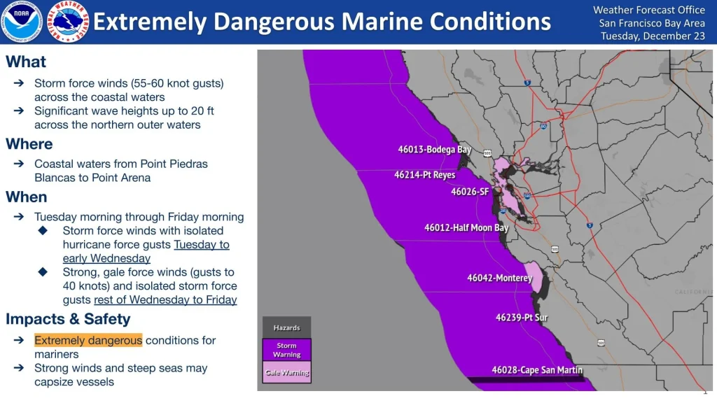
This powerful Pacific storm will also produce extremely hazardous marine conditions along the Northern and Central California coast this week.
The NWS Coastal Waters Forecast for the Point Arena–Point Reyes offshore zone indicates sustained winds exceeding 90 km/h (55 mph) and gusts near 110 km/h (70 mph), with steep combined seas of 5–6 m (16–20 feet).
Such conditions pose serious danger to vessels, particularly small craft and recreational boats, and make navigation extremely difficult even for larger ships. Mariners are advised to remain in port or seek immediate shelter until the system passes.
References:
1 Short Range Forecast Discussion – NWS/WPC – December 23, 2025
2 Excessive Rainfall Discussion – NWS/WPC – December 23, 2025
I'm a dedicated researcher, journalist, and editor at The Watchers. With over 20 years of experience in the media industry, I specialize in hard science news, focusing on extreme weather, seismic and volcanic activity, space weather, and astronomy, including near-Earth objects and planetary defense strategies. You can reach me at teo /at/ watchers.news.
Commenting rules and guidelines
We value the thoughts and opinions of our readers and welcome healthy discussions on our website. In order to maintain a respectful and positive community, we ask that all commenters follow these rules.