
Winter Weather Advisories in effect across Montana through Tuesday morning
Winter Weather Advisories covering mountain regions and the northeastern plains of Montana remain active through early Tuesday, November 25, 2025, with snow, freezing rain, and strong winds generating hazardous travel conditions. Mountain passes, including Lolo, Lost Trail, and Marias, may receive 5–45 cm (2–18 inches) of snow, while northeastern counties face light accumulation, freezing rain, and winds up to 55 km/h (35 mph).

Snowfall forecast for Montana November 24 and 25, 2025. Credit: NWS
The National Weather Service (NWS) has issued and maintained multiple Winter Weather Advisories across Montana effective through Tuesday morning, November 25. Warnings cover most of the state’s mountain ranges and northeastern plains, where snow, freezing rain, and high winds are producing hazardous travel conditions.
Winter weather advisories remain in effect for parts of northeast Montana until 05:00 MST Tuesday for Phillips, Valley, Daniels, Sheridan, Roosevelt, McCone, Richland, Dawson, and Wibaux Counties.
Snow totals are expected to reach 5–13 cm (2–5 inches) in most areas, with winds gusting to 55 km/h (35 mph). Forecasters note that slippery road surfaces could impact Monday evening commutes across cities, including Glasgow, Sidney, and Glendive.
Additional advisories were issued for Fallon and Carter Counties, in southeast Montana, effective 14:00 MST Monday to 11:00 MST Tuesday. Up to 5 cm (2 inches) of snow and wind gusts of 65–90 km/h (40–55 mph) are expected. Blowing snow may reduce visibility and create slick surfaces, particularly along U.S. Highway 12 and State Highway 7.
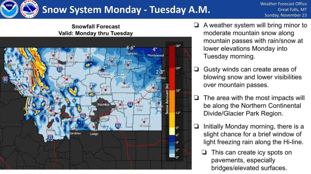
Advisories were also issued for Little Belt, Highwood, Big Belt, Bridger, and Castle Mountains through 23:00 MST Monday in the central Montana mountains. Forecast totals range from 10–20 cm (4–8 inches), with isolated peaks near 30 cm (12 inches) and winds to 80 km/h (50 mph). Similar conditions extend into the Bears Paw Mountains, Blaine County, and portions of Hill County, where freezing rain and light snow could leave a thin glaze on bridges and power lines.
Freezing rain and light snow are forecast to continue early Monday in Glacier, Toole, Pondera, Liberty, and Hill Counties, with gusts up to 65 km/h (40 mph) and light ice accumulation, in North-central and western Montana. The East Glacier Park Region and Southern Rocky Mountain Front may see 13–25 cm (5–10 inches) of snow, with local ridge-top totals near 30 cm (12 inches).
In Western Montana mountain passes, winter weather advisories remained in effect Bitterroot, Sapphire, and West Glacier Regions from late Sunday night through Monday evening.
Valleys may receive 5 cm (2 inches), while higher elevations and passes such as Lolo, Lost Trail, and Marias Passes could accumulate 5–45 cm (2–18 inches), with wind gusts near 55 km/h (35 mph). The NWS warns of moderate to isolated major winter impacts, including hazardous driving and potential temporary closures on key mountain routes.
Residents and travelers have been advised to exercise caution and monitor 511 Montana road condition reports, and secure outdoor objects against strong winds. Bridges and elevated surfaces are expected to freeze first as air temperatures drop overnight.
References:
1 Winter Weather Advisory – NWS – November 24, 2025

I am an Assistant Editor and Severe Weather & Science Journalist at The Watchers, specializing in real-time severe weather coverage, geophysical event reporting, and research-driven scientific analysis. You can reach me at rishav(at)watchers(.)news.
Commenting rules and guidelines
We value the thoughts and opinions of our readers and welcome healthy discussions on our website. In order to maintain a respectful and positive community, we ask that all commenters follow these rules.