
WPC issues Moderate Excessive Rainfall Outlook for south-central Texas, risk expanding into eastern Oklahoma and the Ozarks
The Weather Prediction Center (WPC) has issued a Moderate Risk of Excessive Rainfall for south-central Texas through Thursday, November 20, 2025, with 75–125 mm (3–5 inches) of rain possible and locally higher totals. The same frontal system is forecast to advance eastward into eastern Oklahoma and the Ozarks by Thursday night, bringing a Slight Risk of excessive rainfall to those regions.

National radar image acquired at 06:32 UTC on November 20, 2025. Credit: NWS
A surge of deep Gulf moisture is forecast to continue producing periods of heavy rainfall over south-central Texas through Thursday as a frontal boundary remains nearly stationary across the region.
The Weather Prediction Center (WPC) issued a Moderate Risk of Excessive Rainfall in its Day 1 outlook, valid to 12:00 UTC on November 20, covering the Edwards Plateau and western Hill Country, including the city of Del Rio. The Day 2 outlook continues the threat into Thursday night.
Forecast rainfall totals are in the 75–125 mm (3–5 inches) range, with locally higher amounts possible in convergence zones where multiple rounds of rainfall may occur. Although soils are relatively dry at onset, the region’s steep terrain and thin soils increase runoff potential, elevating the flash flooding risk in creeks, arroyos, and low-lying areas.
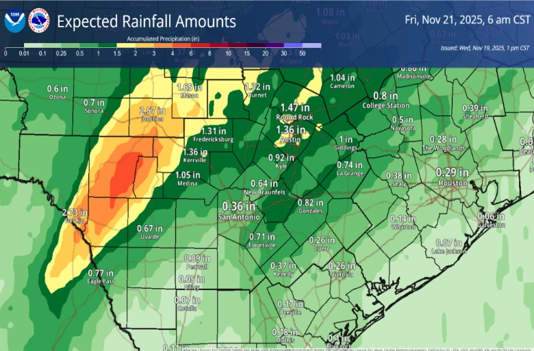
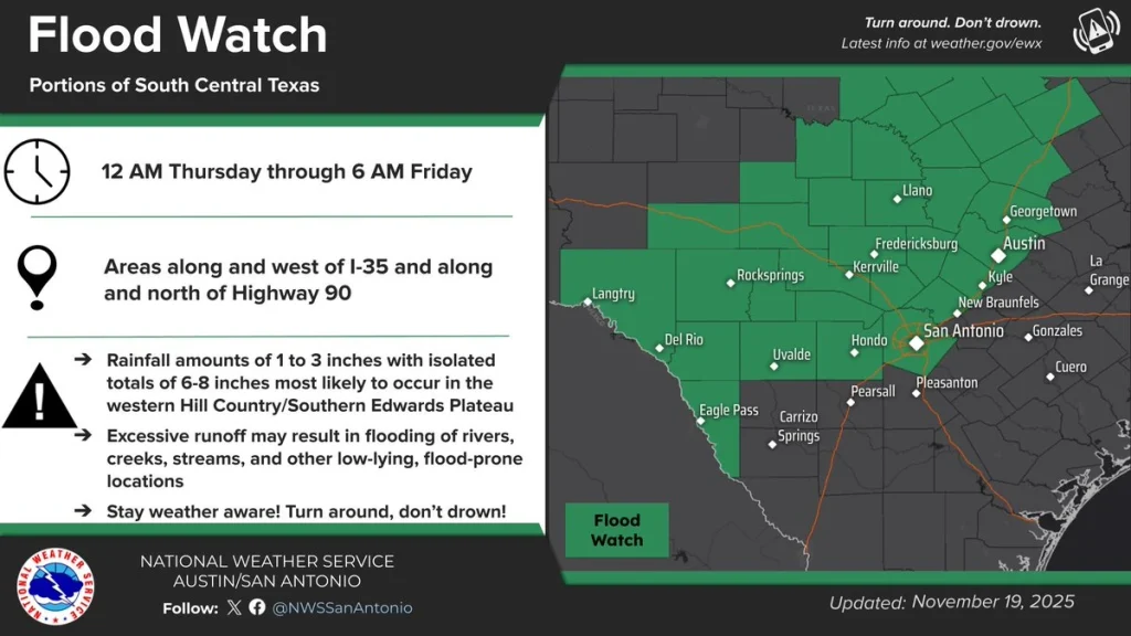
Flood Watches have been issued by National Weather Service (NWS) offices covering south-central Texas, effective through Thursday evening. Excessive runoff may result in flooding of rivers, creeks, streams, and other low-lying, flood-prone locations.
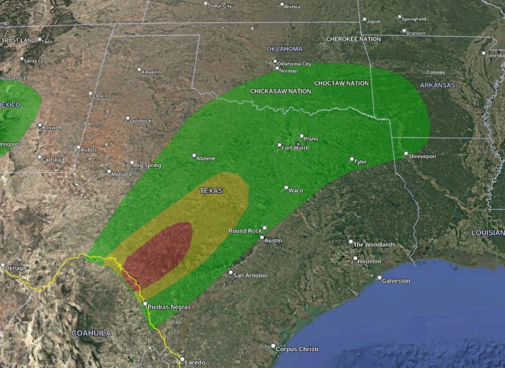
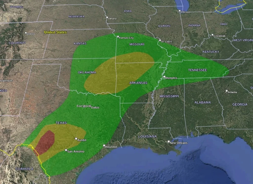
By late Thursday and into Friday, the same system is forecast to progress eastward, spreading showers and thunderstorms into eastern Oklahoma and the Ozarks, where the WPC maintains a Slight Risk of Excessive Rainfall. Forecast accumulations in this area generally range from 25–75 mm (1–3 inches).
By Friday, the frontal system is expected to weaken as it shifts into the Ohio Valley, reducing rainfall intensity across the southern Plains but maintaining scattered showers farther east.
Residents across affected regions are advised to remain alert for flash flood warnings and local advisories, especially overnight when rainfall rates may intensify.
References:
1 Short Range Forecast Discussion – NWS/WPC – 15:49 EST on November 19, 2025
2 Excessive Rainfall Discussion – NWS/WPC – 20:00 EST on November 19, 2025
I'm a dedicated researcher, journalist, and editor at The Watchers. With over 20 years of experience in the media industry, I specialize in hard science news, focusing on extreme weather, seismic and volcanic activity, space weather, and astronomy, including near-Earth objects and planetary defense strategies. You can reach me at teo /at/ watchers.news.
Commenting rules and guidelines
We value the thoughts and opinions of our readers and welcome healthy discussions on our website. In order to maintain a respectful and positive community, we ask that all commenters follow these rules.